January weather in India
(→The lowest minimum temperatures: 2012-21) |
(→6th January) |
||
| Line 745: | Line 745: | ||
= 6th January= | = 6th January= | ||
| + | ==Delhi== | ||
| + | ==2023=== | ||
| + | '''Maximum temperature ''' | ||
| + | |||
| + | 16.5 degrees Celsius Safdarjung, three notches below normal | ||
| + | |||
| + | [[Category:Climate/Meteorology|JJANUARY WEATHER IN INDIAJANUARY WEATHER IN INDIAJANUARY WEATHER IN INDIAJANUARY WEATHER IN INDIAJANUARY WEATHER IN INDIAJANUARY WEATHER IN INDIAJANUARY WEATHER IN INDIAJANUARY WEATHER IN INDIAJANUARY WEATHER IN INDIAJANUARY WEAT | ||
| + | ]] | ||
| + | [[Category:India|J JANUARY WEATHER IN INDIAJANUARY WEATHER IN INDIAJANUARY WEATHER IN INDIAJANUARY WEATHER IN INDIAJANUARY WEATHER IN INDIAJANUARY WEATHER IN INDIAJANUARY WEATHER IN INDIAJANUARY WEATHER IN INDIAJANUARY WEATHER IN INDIAJANUARY WEA | ||
| + | ]] | ||
| + | [[Category:Pages with broken file links|JANUARY WEATHER IN INDIAJANUARY WEATHER IN INDIAJANUARY WEATHER IN INDIAJANUARY WEATHER IN INDIAJANUARY WEATHER IN INDIAJANUARY WEATHER IN INDIAJANUARY WEATHER IN INDIAJANUARY WEATHER IN INDIAJANUARY WEATHER IN INDIAJANUARY WEATH | ||
| + | ]] | ||
| + | [[Category:Pakistan|J JANUARY WEATHER IN INDIAJANUARY WEATHER IN INDIAJANUARY WEATHER IN INDIAJANUARY WEATHER IN INDIAJANUARY WEATHER IN INDIAJANUARY WEATHER IN INDIAJANUARY WEATHER IN INDIAJANUARY WEATHER IN INDIAJANUARY WEATHER IN INDIAJANUARY WEA | ||
| + | ]] | ||
| + | |||
= 7th January= | = 7th January= | ||
==Munnar== | ==Munnar== | ||
Revision as of 12:12, 8 January 2023
This is a collection of articles mainly from the Delhi- based press. |
This page is under construction
January as a whole
Delhi: the coldest Januarys
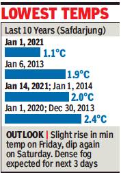
The lowest minimum temperatures: 2012-21
See graphic The lowest minimum temperatures recorded in Delhi in January, 2012-21
1.1°C 2021 January 1
2°C 2021 January 14
2.1 degrees Celsius 2021 January. 26
Delhi/ the warmest Januarys
The warmest days, 1994- 2019

From The Times of India
See graphic, ' Delhi’s warmest January days, 1994- 2019 '
The highest minimum temperature
16 degrees Celsius January 26, 2017
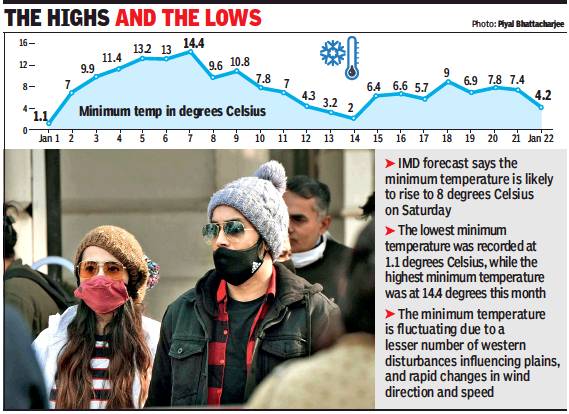
14.4 degrees Celsius Jan 7, 2021
Delhi/ Januarys with erratic weather
2021: Blowing Hot & Cold
Mercury Blows Hot & Cold In January
Minimum Temp Fluctuating Due To Rapid Changes In Wind Direction, Speed
Priyangi.Agarwal@timesgroup.com The Times of India
Intense fluctuations have been taking place in the minimum temperature this month, India Meteorological Department (IMD) data shows.
On January 1, the minimum temperature dipped to the season’s lowest at 1.1 degrees Celsius but rose to 7 degrees Celsius on January 2. The highest minimum temperature was recorded on January 7 at 14.4 degrees Celsius. The minimum temperature settled at 2 degrees Celsius on January 14 but it rose again the next day. On [23 Jan], the minimum temperature dropped to 4.2 degrees Celsius, three notches below normal.
Met officials said that the minimum temperature is fluctuating due to less western disturbance-influencing plains and rapid changes in wind direction and speed. Even cloudy days and clear skies have been changing continuously, affecting the minimum temperature.
Kuldeep Srivastava, scientist at IMD and head, Regional Weather Forecasting Centre, said that a combination of factors has been causing fluctuations in minimum temperature in January. “Only one western disturbance affected the plains in January this year while six western disturbances impacted the plains last year. When the north-westerly winds blow from snow-capped western Himalayan region towards Delhi, it causes a drop in minimum temperature. However, as the wind direction changed many times, it led to sudden decrease or increase in minimum temperature.”
Srivastava added the clear skies make the day warm while the heat quickly dissipates at night, which causes fall in minimum temperature. However, cloud cover leads to rise in minimum temperature.
The maximum temperature recorded on Friday was 18.6 degrees Celsius, three notches below normal. Moderate fog was observed in the city on [23 Jan]
Jammu city
Lowest temperatures recorded in January
Below 1 degree Celsius on January 22, 23 and 24, 2008 .
Kashmir
Lowest temperature in January
Srinagar
Minus 11.3°C Jan 1991
Minus 8.7°C (Airport, Srinagar)/ Minus 8.4°C (Srinagar city and Dal Lake) Jan 14, 2021
Minus 7.8°C Jan 13, 2021
Average monthly minimum temperature in Jan
The average monthly minimum temperature in Srinagar in January, historically, is minus 2.1°C
2021: The average minimum temperature in Srinagar in January 2021 was minuis 3.1°C during the first fortnight of Jan
Lucknow
Lowest maximum temperature
10.2 degrees Celsius/ 2003 January 17
10.6 degrees Celsius/ 2011 January 5
10.6 degrees/ 2023 Jan 3: 10.3 notches below normal
Mount Abu
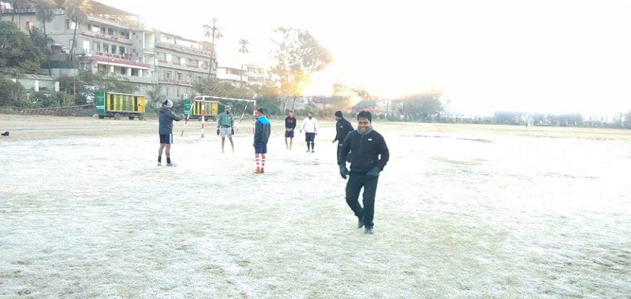
By ER Sanjay, AbuTimes, January 27, 2019
2005 There was a thin crust of ice on the Nakki Lake on January 20/ India Times- The Times of India
2017 Jan 10/ 11: Nakki Lake froze/ VTV
2018 Jan 2, minus -1.4 degrees at Mount Abu, Nakki Lake froze. / VTV and skymetweather.com
2019, Jan 20: Nakki Lake was frozen for a few days after Jan 20./ abutimes
2020 Jan 9: Mount Abu shivers at minus 2.4 degree Celsius/ ABP
Munnar (Kerala)
Lowest daytime temperature
2/9 Freezing temperatures, heavy snowfall in Munnar | Mathrubhumi, Jan 28, 2021
Munnar town - (minus) 2 degree celsius on 26 Jan, 2021 . This was the lowest daytime temperature recorded till then.
Neighbouring areas (minus) -2 degree celsius in Kundala, Devikulam, Lakkad, Thenmala and Chenduvara in mid Jan 2021
North India
Prolonged winter
2019: seven WDs
Highlights
Western disturbances (WDs) are pulses of low pressure winds that travel westwards from in and around Mediterranean region, bringing cold, moist winds that either hit the Himalayas — impacting northern India
This January, seven WDs have hit north India as opposed to the normal of four to six
NEW DELHI: The long and chilly winter in north India this year could be linked to cold blasts from the Arctic region that have been spilling southwards since late December due to the breakdown of a wind circulation called the polar vortex, Indian Met officials said.
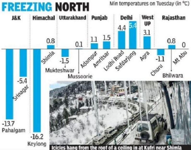
As north India continues to reel under severe cold, with the temperature dropping to -1.1 degrees Celsius in Churu, Rajasthan on [29 Jan] an official in the India Meteorological Department said the sustained chill over the region appears to be linked to the polar vortex breaking up — an event that has brought freezing spells in Europe and is currently unleashing severe snowstorms in the US.
“The cold from the Arctic has been spilling southwards into Europe and US due to the weakening of westerly currents. This seems to pushing western disturbances more southwards than normal towards northern India. In effect, this is transmitting the cold from southern Europe into north India,” said D Sivananda Pai, head of IMD’s long range forecasting.
Western disturbances (WDs) are pulses of low pressure winds that travel westwards from in and around Mediterranean region, bringing cold, moist winds that either hit the Himalayas — impacting northern India — or blow over to the north.
This January, seven WDs have hit north India as opposed to the normal of four to six. “These weather disturbances have been impacting the region every three-four days this month,” said B P Yadav, head of IMD’s Regional Meteorological Centre here.
Ironically, the disruption in the polar vortex was caused by warm winds entering the upper atmosphere over the Arctic causing “sudden stratospheric warming” over the North Pole that sent temperatures in the region rapidly up by tens of degrees. This sent the cold normally trapped in the Arctic spilling out.
The polar vortex is a counterclockwise-spinning rapid current of air that prevents the frigid Arctic weather from escaping into other regions. However, there have been increasing disruptions in the vortex in recent decades because of changes in the jet stream that some studies have attributed to global warming.
The sudden disruption in the polar vortex also seems to have upset IMD’s forecast of a warm winter this season.
The last WD of January hit north India [on 29 Jan].
Panchmarhi
2005 There was frost around Jan 18
Fog
Indo-Gangetic plains
December, January, 1979 -2013
How air pressure change in Arctic is causing fog in Delhi , 24 Jan 2019| The Times of India
A new study of the Indian Institute of Tropical Meteorology (IITM), Pune, has found that abnormal air circulation patterns in two far-away regions — the Arctic and Eurasia — have links to fog over the Indo-Gangetic plains of north India.
Based on an analysis of 105 cases of fog events in the period between 1979 and 2013, the study reported that widespread fog conditions over the Indo-Gangetic plains were connected to the abnormal movement of high pressure systems over the Arctic Circle and the Eurasian middle latitudes.
The Arctic is approximately 9,240km away from India. About 2,910km separates India from Eurasia.
“When an environment with lower air pressure surrounds the Arctic region, the cold air stays locked-up within the Arctic Circle. The development of high air pressure over the Arctic Circle, combined with east-west movements of air circulation over Eurasia, can cause more cold air to advance towards the tropical latitudes and the Indo-Gangetic plains,” said Ramesh Vellore, a scientist from IITM involved in the study.
Sinking of cold air coming from the Arctic and Eurasian regions over the Indo-Gangetic plains allows development of high pressure and favours fog formation in the presence of moisture close to the surface. Fog scenario in the Indo-Gangetic plains commonly occurs because of the development of a highpressure environment over the Himalayan valley.
Researchers suggested a suitable methodology could be devised to improve fog forecast assessment by combining the Arctic and Eurasian aspects. Number of studies in the past have associated the region’s fog lifecycle in this region to increasing pollution particulate matter arising from growing population, rapid urbanisation, biomass burning, and industrial and vehicular activities in the Indo-Gangetic plains.
The study period for the research was December and January months from 1979 to 2013. Daily summaries of surface meteorological observations (temperatures, humidity, winds, surface pressure, rainfall and other indicators of local weather phenomena like thunderstorms, fog and dust storms) documented by the National Data Centre, India Meteorological Department, Pune, were used in the study. Twenty-six stations, three each from Punjab, Haryana, and Bihar, two from New Delhi, 14 from Uttar Pradesh and one from Uttarakhand, were chosen for the study.
Dec 2020
The Times of India 8 Jan 2021
According to IMD, dense fog occurrences over central and eastern parts of Indo-Gangetic Plains (IGP) region was sub-duded [? Subdued?] during December, 2020, while at its extreme western parts that is over Punjab areas, it was higher and more frequently observed. “Daily data shows that dense to very dense fog occurred at a few places to most places over Punjab during December 16-31 last year and at isolated places during December 13-15; at isolated to few places over Haryana, Chandigarh and Delhi on December 13, 16, 22, 24, 25, 30 and 31,” said RK Jenamani, scientist at IMD.
Superfog
2018
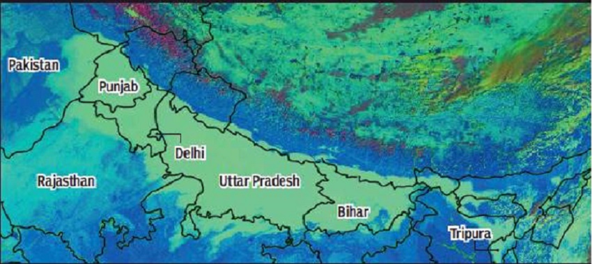
Insat 3D image shows unbroken fog (in pale green) from Pakistan to northeast India at 9.30am on Wednesday
From The Times of India
At 9.30am on 3 Jan 2018, an unbroken layer of fog was spread across more than 2,000km of the Indian subcontinent — starting from central Pakistan in the west, running right through the Indo-Gangetic plains and ending around Tripura.
Experts said, in terms of territory covered, it was one of the largest simultaneously formed, single fog episodes over any land area in the world.
The daytime multi-channel fog detection scheme image captured by Insat 3D shows the fog covering at least four countries — Pakistan, India, Nepal and Bangladesh. The fog actually began on Christmas Day in east UP and Bihar.
15 airports reported fog on Wednesday morning
The only comparable fog episode of this scale will have been from this region itself in previous years. Wednesday’s spread was certainly larger than other fog episodes in places such as central China, Italy or the California valley,” said R K Jenamani, head of the Met office at Delhi’s IGI Airport.
“After covering east UP and Bihar on Christmas, it started covering more areas in its west, including Delhi, by December 31. By January 2, it had covered Punjab and was continuing to move west into Pakistan. It has severely affected aviation, rail and road transport, and caused a sharp drop in day temperatures across the region,” Jenamani said.
Ironically, however, although the fog reached its maximum spread at 9.30am on Wednesday, visibility at many places in north India, including in Delhi-NCR, was in fact better at that time than in the previous two days. “The satellite picture shows the extent of the fog. What it doesn’t show is that at many places, the fog wasn’t actually on the surface but a few hundred metres in the air, like a very low cloud. Technically, it’s still a fog,” said Jenamani.
According to the IMD website, at least 15 airports in the country reported moderate to severe fog between 6.30am and 9.30am on Wednesday. These include Agartala, Patna, Gaya, Guwahati, Gorakhpur, Allahabad, Agra, Lucknow, Varanasi, Rae Bareli, Chandigarh, Jammu, Ludhiana and Pantnagar. The worst hit was Amritsar, which had visibility below 100m for 18 hours, from 6.30pm on Tuesday till 12.30pm on Wednesday.
Delhi, however, had visibility of around 300m. The Met office said visibility would further improve over the next two-three days. Fog is formed when a cold, moist air current meets relatively warm air, leading to formation of fine water droplets.
2023
As in 2018, in 2023 a Super fog took place on the 2nd/ 3rd January
A supergiant layer of fog enveloped north India and adjoining areas on Tuesday morning. Spread across nearly 10 lakh sq km from Pakistan to the edge of Assam, the contiguous blanket of fog covered four countries and at least 13 Indian states, causing zero visibility and “severe cold day” conditions at many places in the region.
Experts said such massive fog formation usually happens once in three to five years, with the last such event having taken place in the winter of 2019-20, during the most prolonged spell of fog in recent times. Tuesday’s fog cover had a three times larger spread than the most widespread event during the last fog spell from December 18 to 28, which peaked on December 27.
The India Meteorological Department released an INSAT 3DR image taken at 8. 45am on Tuesday, whichshows fog and low-cloud-cover across the region, including parts of Pakistan, Nepal and Bangladesh, and spreading to areas in Madhya Pradesh, Chhattisgarh and Odis-ha in central India.
Under its influence, severe cold day conditions were observed over most pockets of Punjab and several places in Haryana, Chandigarh, Uttar Pradesh and Bihar. Cold-day conditions persisted at some areas of Delhi and isolated spots in Rajasthan and Madhya Pradesh.
“Such a massive fog event has a cascading effect, with day temperatures plunging over a huge area and impacting a large population. Besides, low-visibility conditions create hazards for road, rail, and air traffic,” said R K Jenamani, senior IMD scientist.
Jenamani said such widespread fog usually occurs during periods of prolonged absence of active western disturbance (WD) in north India. The northern plains haven’t been impacted by an active WD since October.
“Apart from the absence of a WD, we need light or calm wind conditions and the presence of moisture across a large area for such massive fog formation. On Tuesday, we saw an elongated line of subsidence of air which caused atmospheric inversion to take place over a huge area,” he said.
Rainfall
Delhi: Rainfall, 1901-2022

Graphic courtesy: The Times of India
Rainfall recorded in January at Safdarjang, Delhi: 1901-2022
Delhi/ Years of high rainfall, 1999-2019
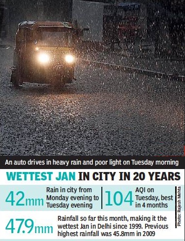
From 23 Jan 2019 The Times of India
59.7mm of rain in January 1999.
47.9mm rainfall: 1-22 Jan 2019.
45.8mm rainfall in January 2009.
Indpaedia adds: By a coincidence, the three years with the highest rainfall in the period 1999-2019 all ended in a 9. In other words, very high January rainfall occurs in Delhi after every ten years.
2014-2020
Amit Bhattacharya, January 31, 2020: The Times of India
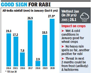
From: Amit Bhattacharya, January 31, 2020: The Times of India
This winter season continues to make news. December saw record-breaking cold in the north and now January is the wettest India has experienced in 15 years. Met records show countrywide rainfall during this month has been 67% above normal (till January 30), with north, and east and northeast regions receiving almost 80% surplus rains.
Experts said the wet and cold conditions during January, particularly over north India, have been ideal for rabi crops such as wheat, which is heading for a bumper harvest.
Record wheat harvest likely
All-India average rainfall in January so far has been 27.9mm, highest since 2005, when 28.1mm was recorded, met records reveal. Winter rainfall is regulated by western disturbances (WDs) — pulses of moist winds travelling from regions close to the Mediterranean.
“Normally, there are five to seven WDs in January. This month, we got 10. Many of them came in through a southerly path which brought rainfall to northern plains in addition to the western Himalayan states,” said Mrutyunjay Mohapatra, head of IMD.
“This month, we saw several of the WDs being supported by easterly winds from Bay of Bengal. The confluence of the two systems increased the geographical spread of the rainfall,” Mohapatra said. Several agencies have forecast a record wheat production this year.
2017-2021: high rainfall days
From Priyangi.Agarwal@timesgroup.com
The highest single-day rainfall in January
30.3mm on January 27, 2017,.
25.1mm rainfall from 8.30am on 2 Jan 2021 to 8.30am on 3 Jan 2021 and another 14.8mm rainfall till 5.30pm on 3 Jan 2021 at the Safdarjung observatory. . 3 Jan 2021 : The Lodhi Road and Aya Nagar stations recorded 18.6mm and 15.2mm rainfall, respectively. The maximum temperature on 3 Jan 2021 dipped to 15.8° Celsius, four notches below normal. the minimum temperature settled at 9.9 degrees Celsius, three notches above the normal.
48.1mm rainfall over six days: Delhi had, received in January 2020,.
1995- 2021: high rainfall months
Monthly average rainfall in January 21.7mm
Highest (total) rainfall in January in Delhi
69.8mm in 1995
59.7mm in 1999.
56.6mm in Jan 2021, till 6 Jan
54.1mm in 2019
Snowfall
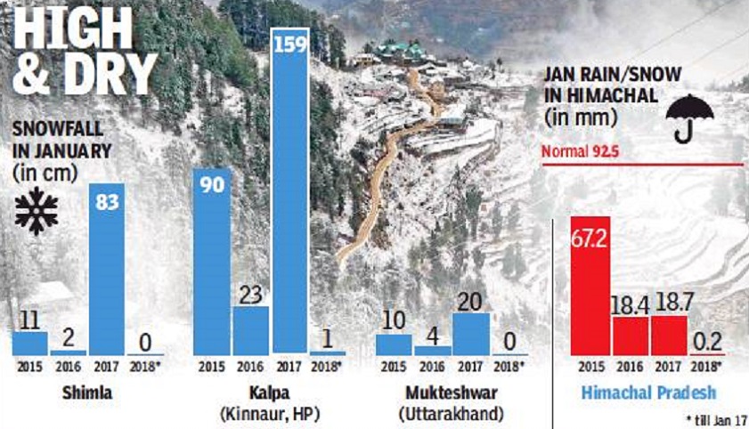
HP and Uttarakhand, 2015-18
See graphic, ' January snowfall in HP and Uttarakhand, 2015-January 17, 2018 '
HP, Uttarakhand, 2018
Apple Crop, Water Supply Could Be Hit
2018-01-18: The peak winter period is almost over in north India and no major hill station in Himachal Pradesh and Uttarakhand has yet received a single spell of snow. January has been almost totally dry across the region so far
Uttarakhand has a 100% rain deficit in January so far, while in Himachal Pradesh it is more than 99%. The northern plains too have had no rain in January, which is a major reason for the mild winter so far.
In fact, just one major wet spell has hit north India this winter. That came around December11-12, when most parts of the plains got rain while the higher reaches of the Himalayas had snowfall. For the rest of December, rain/snow remained confined to Jammu and Kashmir and a few places in the higher Himalayas.
This winter, the position of western disturbances (WDs) coming into north India has been more northerly than usual. These have mainly affected northern J&K, leaving almost no impact on the rest of the region. Most of the WDs have also been feeble,” said Kuldeep Srivastava, head of the IMD’s Regional Weather Forecasting Centre.
WDs, which are waves of cold, moist winds coming in from southern Europe and west Asia, are the only source of wet weather in winter across north India. WDs also regulate the weather during the season, bringing in cold spells in their wake.
“Shimla hasn’t recorded any snow this winter. In January, it hasn’t even rained so far. If the dry weather continues through the month, it would be the first time in 11 years that Himachal’s capital will go snowless in January,” said Manmohan Singh, head of Shimla’s Met office.
The official said there was growing concern over the impact of the dry weather on the state’s apple production, as the minimum number of chilling hours required for a good output has not been met so far. “Low snowfall accelerates melting of glaciers. In low snowfall years, Himalayan rivers have less water in summer which impacts irrigation in downstream states such as Punjab and Haryana while hitting hydro-power production,” Singh said.
“There has been no snow activity yet in Uttarakhand this month due to absence of any strong WD,” said Bikram Singh, director of the regional Met centre in Dehradun. Mukteshwar, where the sole IMD snow gauge in the state is located, is yet to record any activity this winter.
Mallika Virde, environmental activist and sarpanch of a van panchayat near Munsiyari, a town at the base of the Panchachuli peaks in Pithoragarh district, said the town received just one snow spell this winter.
HP: Jan 2018, 2019
From The Times of India
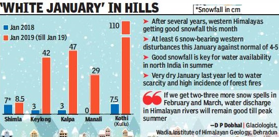
See graphic, ' Snowfall in HP in Jan 2018 and till 19 Jan 2019 '
From The Times of India
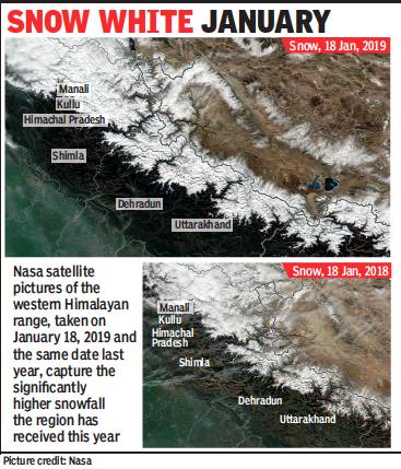
See graphic, ' The difference between Jan 2019’s snowfall and what was seen in January 2018, which was a particularly dry month, is clearly captured in Nasa’s satellite images '
2019: till 19 Jan
January continues to be “white” in the hills of north India as the month’s fifth spell of snow hit the region from 18 Jan. The difference between this season’s snowfall and what was seen last January which was a particularly dry month — is clearly captured in Nasa’s satellite images.
Good snowfall is crucial for water availability insummer months, across north India. “This is the best snowfall we have had in Uttarakhand in at least the last three years. Snow is the main source of water in the Himalayan rivers that feed the northern plains. If we get two-three more snow spells of in February and March, water discharge in the rivers will remain relatively high till peak summer,” said D P Dobhal, glaciologist at the Wadia Institute of Himalayan Geology in Dehradun.
Uttarakhand’s lone snow gauge at Mukteshwar has only recorded trace snowfall this month (on January 6), indicating that the lower hills in the state haven’t received much snow yet. However, the higher reaches are covered in white, including the Badrinath and Kedarnath shrines. “In Munsiyari in Pithoragarh district, we have had around five spells of snow so far this winter, which is around normal,” said mountaineer Mallika Virde, who lives in Sarmoli village, near Munsiyari.
Srinagar has already received 54cm of snow, very close to the entire month’s normal of 57cm. “We expect above normal snowfall this winter,” said Sonam Lotus, chief of Srinagar Met department.
Himachal too is in line for record snowfall. Kothi in Kullu district has received 110cm of snow this month, nearly 15 times more than what it got last January (7.5cm). “Temperatures have been quite low this month. This, coupled with frequent western disturbances, has brought heavy snow in many districts of Himachal,” said Manmohan Singh, head of the regional met department at Shimla.
Shimla has received 8.5cm of snow so far this month, surpassing last January’s 5cm, with more expected in the next few days.
1st January
Munnar/ minus 4°C, 2009
Chenduvarai near Munnar recorded a low of -4 degree Celsius on January 1, 2009, the lowest in memory.
North India freezes. 2021
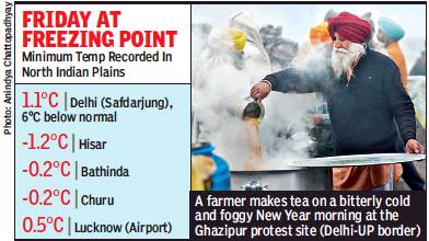
Great Friday Freeze: Sub-zero temps in 3 cities even in plains
Amit.Bhattacharya@timesgroup.com
It was a freezing Friday over the northern plains of the country as the mercury dropped to below-zero in as many as three cities, with
Hisar in Haryana recording -1.2 degrees Celsius
Churu (Rajasthan) -0.2 degrees Celsius
Bathinda (Punjab) -0.2 degrees Celsius ,.
While it’s rare for so many places in the plains to record temperatures below freezing point in a single day, two other cities clocked near-zero temperatures.
Faridkot in Punjab 0.2 degrees C
Narnaul in Haryana 0.2 degrees C.
Lucknow airport clocked 0.5 degrees C
Delhi reported its lowest January temperature of 1.1 degrees C at Safdarjung.
2nd January
Jammu & Kashmir
2018
Jammu Minimum temperature was 6.0 degree C
Kargil minus 6.1 degrees Celsius
Leh minus 14.7 degrees
3rd January
Central Pakistan to Tripura
See Fog> Superfog above
2018: 'Superfog'
2023
As in 2018, in 2023 the Super fog took place on the 3rd January
Jammu & Kashmir
2018
Fog hits train, air service; 2 flights cancelled
Banihal maximum 16.5 degree C and minimum zero degree Celsius,
Batote maximum 13.2 deg C and minimum 2 degree C.
Bhaderwah maximum 12.6 deg C and minimum minus 0.1 degree C. Bhaderwah experienced snowfall in the higher reaches during last 24 hours.
Bhaderwah-Bani road also experienced heavy snowfall in the Chatergala Pass area.
Gulmarg recorded a low of minus 6.8 degree Celsius while the day temperature of the place was 1.8 degree Celsius, 0.2 degree Celsius above normal.
Jammu recorded season’s lowest temperature: 4.3 Deg C, which is about 3 degree below normal. Maximum 15.1 degree C
Kargil town recorded coldest night of the season: 20 degrees below the freezing point. The minimum temperature in Kargil town plummeted over 14 degrees from the previous night’s low of minus 6.1 degrees Celsius to settle at a low of minus 20.6 degrees Celsius. Kargil was the coldest recorded place in the State
Katra recorded a maximum temperature of 17 degree C and minimum 6.2 deg C,
Kokernag recorded minus 1.7 degree Celsius while the day temperature of the place settled at 8.6 degree Celsius, 3.0 degree Celsius above normal.
Kupwara recorded a low of minus 3.8 degree Celsius while the day temperature of the place was 8.6 degree Celsius, 3.0 degree Celsius above normal.
Leh town recorded a minimum temperature of minus 16.6 degrees Celsius last night down from minus 14.7 degrees the previous night. This was the lowest night temperature of the season last night in Leh as well.
Pahalgam recorded minus 6.1 degree Celsius while the day temperature of the place settled at 8.0 degree Celsius, 3.2 degree Celsius above normal.
Qazigund recorded minus 4.0 degree Celsius last night while the day temperature settled at 10.0 degree Celsius, 2.9 degree Celsius above normal.
Srinagar recorded minus 4.1 degree Celsius temperature last night while the day temperature settled at 10.7 degree Celsius, 3.8 degree Celsius above normal.
A senior official at Jammu Airport said that due to dense fog in parts of Jammu and the northern region, two flights of Indo Airways and Air India were cancelled today while most of the flights were delayed. The first Indigo flight could land only at around 1.20 pm today at Jammu Airport. All other flights operated thereafter. He said not only in Jammu, the dense fog in Delhi and other parts of northern region delayed the operation of flights. The train services were also badly delayed in the region due to poor visibility and foggy weather conditions. A Northern Railways spokesman said that Indore- Jammu Express was delayed by three hours, Kolkata- Katra by two hours, Shiv Shakti by two hours, Hemkund Express also by two hours, Bathinda-Jammu Express by 6 hours, Sialdah Express by 7 hrs, Kathgodam Garibrath by 7 hours, Jhelum Express by 10 hours, Archana Express by 7 hours, Ahmedabad-Udhampur Express by 18 hours, Tata Moorie by 17 hours, Jamnagar-Jammu by 10 hours, Malwa Express by 6 hours while other trains by one to two hours.
The inter-state bus service in the region has also been affected badly due foggy weather conditions.
North India
2023
Maximum temperature
Amritsar, Punjab, 9. 5 degrees Celsius, 8. 5 notches below normal.
Bahraich, east UP, 11 degrees C.
Bareilly, west UP, 10. 6 degrees C
Patna 14. 5 degrees C/ 7. 5 notches below normal.
Minimum temperature
Churu, Rajasthan: below freezing at minus -0. 9 degrees C, making it the coldest place in the northern plains.
4th January
5th January
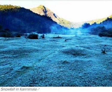
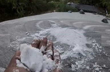
Munnar, Kerala/ minus 3°C, frost; ‘snowfall' in Kannimala/ 2019
From The Times of India
From The Times of India
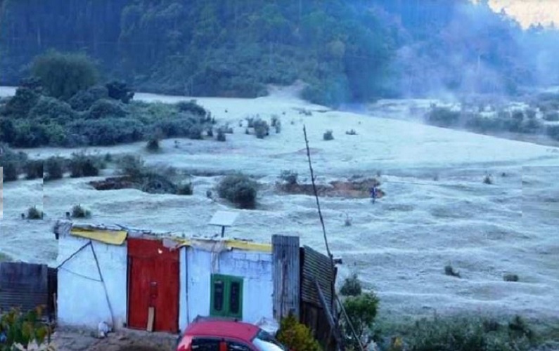
KOCHI: Parts of popular hill station Munnar witnessed sub-zero temperatures with Chendura, Chittuvara and Lakkad recording minus 3 degrees Celsius on 5th Jan.
Thick layers of frost and fog turned the grassland areas into a white carpet across the entire land.
The meteorological department said that dry weather prevailed with minimum temperatures falling well below normal in Malappuram and Kollam districts. Idukki, Wayanad, Alappuzha, Kannur, Ernakulam and Thiruvananthapuram districts recorded fall in minimum temperatures on 6th Jan.
On 5 and 6 Jan, temperatures in Munnar town, Gudarvila, Nallathanni, Kannimala, Lakshmi and Kundala touched as low as minus 1 degree Celsius. Grasslands and plantations wore a snowy look as frost carpeted the land in many places.
Farmers in Munnar said that the drop in minimum temperatures would impact the crops, especially in the budding season as plants are very stressed out, trying to beat the frost in the night.
6th January
Delhi
2023=
Maximum temperature
16.5 degrees Celsius Safdarjung, three notches below normal
7th January
Munnar
Minus 4°C, 2019
The cold wave continued to grip Kerala with the season’s lowest temperature of minus four (-4) degrees Celsius being recorded at Chenduvarai near Munnar.
Haryana, Punjab
2023
Minimum temperature on night of 7/ 8 Jan
Adampur 2.8 degrees
Ambala's 4.9 degrees.
Amritsar 6.6 degrees,
Bathinda 3.4 °C
Bhiwani 4 degrees Celsius,
Chandigarh 4.5 degrees Celsius.
Faridkot 5.6 degrees,
Gurdaspur 4.5 degrees Celsius
Hisar 1.4 degrees Celsius.
Ludhiana 5.3 degrees Celsius,
Mohali 5.7 degrees.
Narnaul 3 degrees
Pathankot 6.6 degrees,
Patiala 4.3 degrees Celsius,
Rohtak 3.8 degrees,
Rupnagar 3.3 degrees Celsius.
Sirsa 3.2 degrees Celsius.
Maximum temperature on 7 Jan
11 degrees Celsius to 15 degrees Celsius at most places.
8th January
9th January
10th January
11th January
Munnar/ frost fall, minus 1°C, 2020
IDUKKI: White sheets of snow-covered Munnar on Saturday morning as the temperature in the hill station dropped to minus one degree.
The temperature which plummeted at the hill station recently fell further on Friday, thrilling tourists who visited Munnar for the weekend. The hill station which experienced hot climate for over a month has welcomed the year’s chilliest climate.
The drop in temperature has also revived tourism in Munnar, with hordes of tourists making a beeline here. Hoteliers, who were facing a slump in business since July [2019?], are also anticipating better days. Mattuppetty, Kundala, Ellappetty and Chenduvara recorded minus one degree Celsius on Saturday while Lakshmi, Kannimala, Sevenmala and Nayamakkadu witnessed freezing temperature.
The golf ground in Kundala was also blanketed in a thick layer of frost. The hill station is expected to remain at minus temperature until February end. The high-altitude Munnar marathon will also be held soon to attract tourists. This year, the snowfall is expected to make the competition more attractive.
12th January
13th January
14th January
15th January
16th January
Delhi/ 21.3°C mx, 4.5°C min, 2019
Expect cold wave conditions to continue, January 17, 2019: The Times of India
The maximum temperature was 21.3 degrees Celsius, one notch above normal, while the minimum was 4.5 degrees Celsius, three degrees below average. This is the coldest January 16 in terms of minimum temperature since 2012.
17th January
18th January
19th January
Delhi/ 25.9°C mx, 5.7°C min, 2019
The mercury rose to 25.9°C— six notches above the average The rise in temperature was due to a western disturbance, a Met department official said. The minimum which was recorded at 5.7°C — one notch lower than normal
20th January
Delhi/ 28.7°C warmest January day since 2007; mn 7°C/ 2019
A day before wet weather hit the capital, the mercury climbed to 28.7°C on 20th, seven notches above normal, making it the warmest January day in the city in 12 years and the second warmest in at least 27 years. The sharp rise in temperature was caused by warm southerly winds sucked into the region by the western disturbance that [was] forecast to bring rain [the next day].
21st January
22nd January
Delhi/ 12°C mn (very high), 2014
The minimum temperature on January 22: in 2014, it touched 12 degrees Celsius, being the highest then.
Delhi/ 19.4°C mx, 12.5°C mn (very high), very heavy rain, 2019
Rainfall in Jan 2019 Wettest January since 1999 stalls capital The Times of India 23 Jan 2019
Heavy rain, thundershower and hail lashed many parts of the city from 21 Jan night and continued till 22 Jan morning. After the overnight rainfall, heavy overcast conditions in the morning plunged the city into pitch darkness before another rain spell hit Delhi, making this the wettest January in the city since 1999.
From Monday night to Tuesday 8.30am, 14.8mm rainfall was recorded at Safdarjung, 26.1mm at Ayanagar and 22.8 at Palam. From 8.30am to 5.30pm, 27.2mm was recorded at Safdarjung, while Ayanagar and Palam recorded 16.9mm and 6.2mm, respectively.
On Tuesday, the maximum temperature was 19.4 degrees Celsius, two notches below normal, while the minimum was 12.5 degrees Celsius, five degrees above normal. This is the highest minimum temperature on January 22 since 2012.
23rd January
Delhi/ 19.9°C mx, 8°C mn; 27.8mm rain/ 2019
Humidity levels oscillated between 77% and 100%.
Delhi’s minimum on Wednesday was 8 degrees Celsius and the maximum 19.9, one degree below normal for this time of the season. Dense fog affected both train and flight operations as the visibility fell below 200 metres.
After recording the cleanest air quality index (AQI) of 104 (moderate) in four months on 22 Jan, the city air returned to ‘poor’ on 23 Jan with an overall AQI of 212.
An official said 27.8mm of rain was recorded in the last 24 hours.
An IGIA official said seven flights were diverted to nearby airports. Though no flight was cancelled, the schedule of around 100 got disrupted. At least 10 trains got delayed. “The early fog warnings at IGI Airport on Monday was the reason why not many flight operations were impacted,” said an official. A DIAL spokesperson said the visibility took a dip around 8am and became normal around 1pm.
24th January
25th January
Delhi: 21.4°C/ 4.8°C, 2020
Fog expected on R-Day morning, rain likely on Tues
TIMES NEWS NETWORK
New Delhi:
It was a chilly morning in the city with the minimum temperature dipping to 4.8 degrees Celsius, three notches below normal.
“The maximum temperature was recorded 21.4 degrees Celsius, a point below normal,” a MeT official said.
26th January
Areas near Munnar, 2021
Freezing temperatures, heavy snowfall in Munnar | Mathrubhumi, Jan 28, 2021
The temperatures were 0 degree celsius at Nallathanni. -1 degree celsius at Lakshmi, 0 degree celsius at Sevanmala, -2 at Silent Valley, -3 at Thenmala, 2 degree celsius at Mattupetty, 2 degree celsius at Chenduvara.
There was heavy snowfall in plantation areas as the temperatures dropped below zero.
27th January
28th January
Delhi, 5°C mn/ 2012
January 28 2012 the minimum temperature had dropped to 5.
Delhi, 18.9°C mx, 5.5°C mn/ 2019
Chill to stay today amid shallow fog The Times of India
The capital saw a chilly day on Monday as the maximum and minimum temperatures touched 18.9 and 5.5 degrees Celsius, respectively, three notches below normal. This was the chilliest January 28 since 2012.
29th January
Churu minus 1.1°C; Himalayas freeze; UP, Punjab cold/ 2019
From The Times of India
See graphic, 'Minimum temperatures in North India on 29 Jan 2019 '
30th January
31st January
See also
January weather in India <> February weather in India <> March weather in India <> April weather in India <> May weather in India <> June weather in India <> Summers: India<> July weather in India <> August weather in India <> September weather in India <> Monsoons: India<> October weather in India <> November weather in India <> December weather in India <> Winter rains: India <> Winters: India
