National Capital Region (NCR) India: Green cover
Contents |
Vegetation (‘green cover’) and water bodies lost to urbanisation (1999-2012)
Green cover equal to 23% of Delhi lost in 13 yrs
Dipak Kumar Dash TNN 2013/07/04
New Delhi: Green cover and water bodies almost equal to a quarter (23%) of Delhi’s area have been lost to development works and rabid urbanization in the National Capital Region (NCR) in the past 13 years.
The first comparative satellite-based study of change in land use in NCR has shown that between 1999 and 2012, the region lost 32,769 hectares of green areas and 1,464 hectares of water bodies, both crucial for sustainability and quality of life in the region.
During the same period, the study found that built-up area in NCR grew 34%, bringing 95,803 hectares of land into the construction zone.
The study was conducted by the National Remote Sensing Centre (NRSC) at the instance of the NCR Planning Board (NCRPB). It’s most striking finding was the substantial loss of green cover in Delhi and areas of Uttar Pradesh, Haryana and Rajasthan.
Of the total loss of 32,769 hectares of green cover, the maximum loss was recorded in NCR areas of UP (17,386 hectares), followed by Haryana at 8,716 hectares. ‘Green’ Delhi too lost 733 hectares of forest/ green land during this period, according to the draft regional plan prepared by the NCRPB.
The other alarming indicator of unsustainable growth in NCR was the loss of water bodies, reduced by 1,464 hectares. Again, the maximum loss took place in UP sub-region at 934 hectares. The Haryana sub-region bucked the trend, increasing the area under water bodies by 261 hectares.
The NRSC report also shows that environmentally fragile areas such as the Yamuna riverbed, wetlands, ridge areas and forests were being steadily usurped for development activities.
The UP and Haryana subregions, which include Gurgaon, Noida, Ghaziabad and Faridabad, showed a massive increase in built-up area during the study period. According to the report, the maximum increase took place in the UP sub-region, where built-up area jumped from 83,214 hectares in 1999 to 1.24 lakh hectares in 2012.
BARE NCR
NCR lost green cover and water bodies equal to 23% of Delhi’s area in 13 years
34% increase in constructed area during same period
Maximum green cover loss in NCR areas in UP, followed by Haryana and Delhi, which lost 733 hectares
NCR areas in UP also registered maximum growth in built-up area (up by 41,000ha), followed closely by Haryana (38,000ha)
Bucking the trend, Rajasthan sub-region showed increase in land under agriculture
’Compensatory plantations’ in villages around Delhi
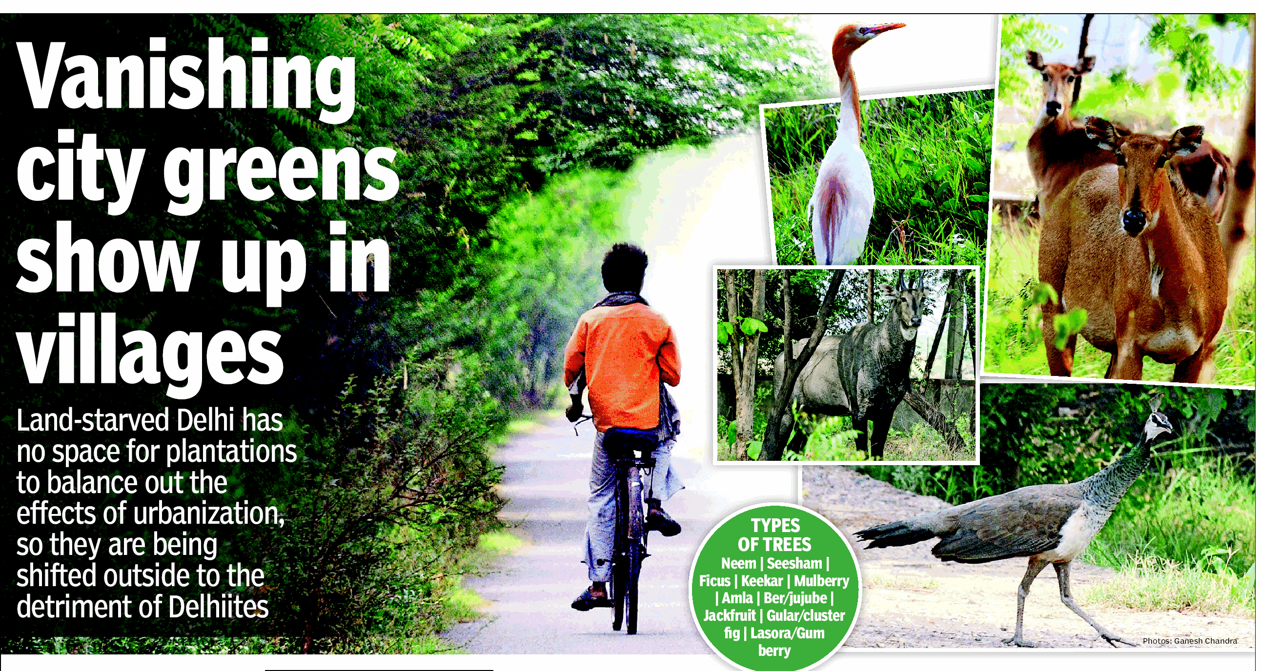
Vanishing city greens show up in villages
Jayashree Nandi, TNN Jul 8, 2013
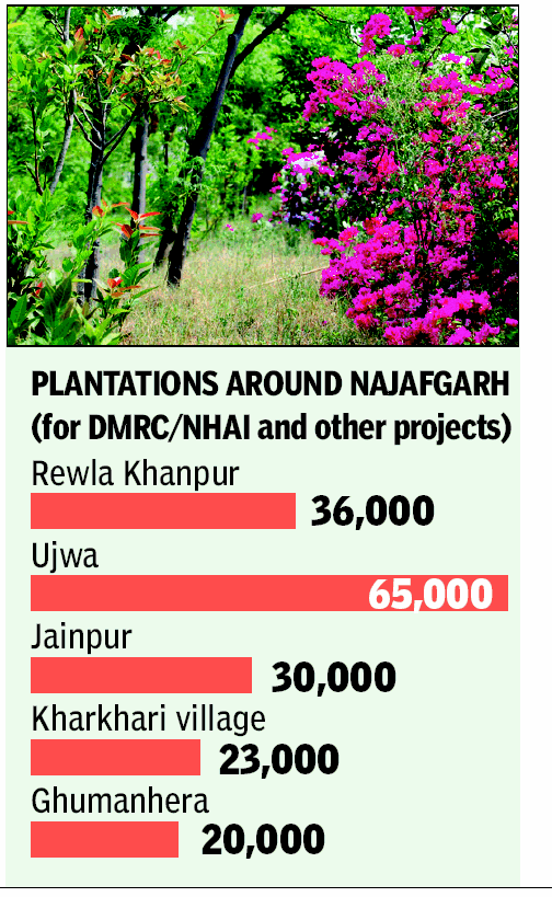
About 40km from the heart of Delhi, mini forests thrive inside the Rewla Khanpur village. When The Times of India visited the area, we were treated to the sight of nilgai grazing and birds chirping; the trees, though not fully grown, were luxuriant enough to provide shade.
Mini forests have come up in Rewla Khanpur and other villages like Kharkhari and Ujwa in Najafgarh to compensate for the lakhs of trees felled in the city to facilitate infrastructure projects like the Metro, highways and flyovers. About 48,000 trees were cut to make way for the Delhi Metro network.
Delhi Preservation of Trees Act, 1994 says every user agency felling trees for a project will have to fund planting of 10 saplings. The villagers don't mind the plantations. Forest officers fear that very soon there will be no land left for such plantations. Between four deputy conservator of forests (DCF), they receive at least a thousand applications for afforestation projects by user agencies. DMRC will divert some forest land for Phase 3, and afforestation will be done by the Compensatory Afforestation Fund Management and Planning Authority (CAMPA) for Delhi. Plantations are also being done in Nangloi and Alipur ranges of the west and northwest districts.
"Plantation in an area like the central ridge is difficult owing to the preponderance of keekar trees, which inhibit the growth of other species. Land in the villages is free from such constraints and is usually fertile," says a forest officer. Najafgarh also has some young plantations, about three years old. Unlike manicured plantations where saplings are planted in rows, these plantations are developed like natural forests.
"The idea is create a forest-like environment so that there is room for fauna. Many birds make nests in the grasslands, also used by reptiles, so we don't prune the foliage," . Only hardy saplings can withstand extreme weather and become a part of the forest. Another difficulty is that plantations are found in patches.
Most of DMRC's compensatory plantations are in Najafgarh. Agencies pay Rs 28,000 to the forest department for planting 10 trees. If they manage to do half of the plantation, Rs 14,000 is refunded. "Some of these plantations are excellent, while some are poorly done. There is no space in left in Delhi and planting 10 saplings for every tree is very ambitious
Farm use up in Rajasthan sub-region
NCR areas of Haryana, which have the highest concentration of land under built-up area at 35.46%, were a close second. The built-up area there grew from 93,996 hectares to 1.32 lakh hectares.
The Rajasthan sub-region was the only area under NCR which actually registered an increase in the area under agriculture use by 23,966 hectares. In contrast, Haryana saw the highest conversion of agriculture land (17,539 hectares) for non-agricultural use.
The report says that the increase in built up area mainly came from conversion of agriculture land, green areas, water bodies and waste land. It says in the absence of proper legislation to control land use in the agricultural (rural) zone, the conversion of these areas for use by industries and educational institutions has continued unabated.
The draft regional plan asks states to follow stricter norms to protect and increase green cover. The plan proposes that expressways be lined with 100m wide green buffer zones on each side. It recommends a 60m green belt for national highways and 30m for state highways and railway lines.
1999-2012: depletion of forest, water bodies, wasteland
NCR greens eroding at alarming rate
New Delhi
The Times of India Jul 14 2014
Board Maps Eco Zones From 1999 To 2012, Sends Notices For Violating Plan Faridabad district almost
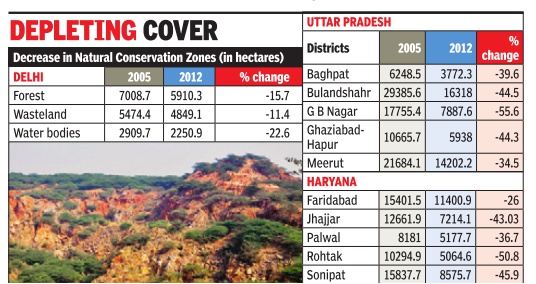
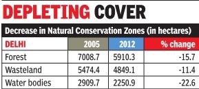
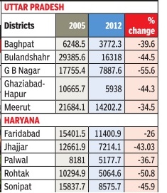
Between 1999 and 2012, there has been an alarming depletion of Natural Conservation Zones--forest, water bodies and wasteland--in the NCR. In Delhi, waterbodies shrunk by 22.6%, forests by 15% and wasteland by 11%, while in NCR, the maximum reduction in such areas was 55% in Gautam Budh Nagar.
After compiling the wide variations in NCZs, the NCR Planning Board (NCRPB) has asked Delhi, Haryana, Uttar Pradesh and Rajasthan governments to respond why they failed despite these areas being marked in the 2005 Regional Plan.
The notices were issued after superimposing the latest satellite images on the regional map that was notified in 2005, sources said. “This is the first time NCRPB has sent notices to hold authorities accountable for failing to enforce the plan. What is the point of having a plan if states don't abide by it?“ asked a government official. While the overall reduction in NCZs in Delhi is only -15.43%, the loss has been maximum with regard to water bodies which are crucial for a water deficient city. According to NCRPB, the NCZs have depleted in areas including Bawana, Asola, Mandi, Puth Khurd, Alipur, Burari, Mehrauli and Aya Nagar. NCRPB has mentioned specific areas with evidences.
In NCR, the maximum fall in NCZs was detected in Uttar Pradesh at 44%. Out of the five districts, Gautam Budh Nagar has the worst record, Bulandshahr and Ghaziabad-Hapur have also fared badly to protect NCZs. Construction activities across the region seem to have dented green zones, a central government official said.
In Haryana, the decrease in areas falling under NCZ is maximum in Rohtak at 51% while in Sonipat it is 45.6% and 43% in Jhajjar.
However, in Gurgaon 99% the NCZs have not been touched yet, though the state government has been pushing for more real estate activities in Aravalis. “The SC order against mining and vigilant green activists in Gurgaon have contributed to this,“ said a forest department official.
But in the neighbouring Faridabad district almost one-fourth of such critical green zones has depleted.
Sources said NCRPB secretariat has pointed out how in 20 cases out of 45 NCZs in Haryana built up areas have been noticed.
The situation is no better in Alwar district in Rajasthan, which also falls under NCR. While the overall percentage change in the NCZ between 1999 and 2005 is about -11%, there is an alarming decrease of water bodies.
It's about 59% in this arid district.
1999-2012: Greens eroding at alarming rate
NCR greens eroding at alarming rate
The Times of India Jul 14 2014
Board Maps Eco Zones From 1999 To 2012, Sends Notices For Violating Plan Faridabad district almost
Between 1999 and 2012, there has been an alarming depletion of Natural Conservation Zones--forest, water bodies and wasteland--in the NCR. In Delhi, waterbodies shrunk by 22.6%, forests by 15% and wasteland by 11%, while in NCR, the maximum reduction in such areas was 55% in Gautam Budh Nagar.
After compiling the wide variations in NCZs, the NCR Planning Board (NCRPB) has asked Delhi, Haryana, Uttar Pradesh and Rajasthan governments to respond why they failed despite these areas being marked in the 2005 Regional Plan.
The notices were issued after superimposing the latest satellite images on the regional map that was notified in 2005, sources said. “This is the first time NCRPB has sent notices to hold authorities accountable for failing to enforce the plan. What is the point of having a plan if states don't abide by it?“ asked a government official. While the overall reduction in NCZs in Delhi is only -15.43%, the loss has been maximum with regard to water bodies which are crucial for a water deficient city. According to NCRPB, the NCZs have depleted in areas including Bawana, Asola, Mandi, Puth Khurd, Alipur, Burari, Mehrauli and Aya Nagar. NCRPB has mentioned specific areas with evidences.
In NCR, the maximum fall in NCZs was detected in Uttar Pradesh at 44%. Out of the five districts, Gautam Budh Nagar has the worst record, Bulandshahr and Ghaziabad-Hapur have also fared badly to protect NCZs. Construction activities across the region seem to have dented green zones, a central government official said.
In Haryana, the decrease in areas falling under NCZ is maximum in Rohtak at 51% while in Sonipat it is 45.6% and 43% in Jhajjar.
However, in Gurgaon 99% the NCZs have not been touched yet, though the state government has been pushing for more real estate activities in Aravalis. “The SC order against mining and vigilant green activists in Gurgaon have contributed to this,“ said a forest department official.
But in the neighbouring Faridabad district almost one-fourth of such critical green zones has depleted. Sources said NCRPB secretariat has pointed out how in 20 cases out of 45 NCZs in Haryana built up areas have been noticed.
The situation is no better in Alwar district in Rajasthan, which also falls under NCR. While the overall percentage change in the NCZ between 1999 and 2005 is about -11%, there is an alarming decrease of water bodies. It's about 59% in this arid district.
“We need to protect all Natural Conservation Zones, which are crucial for the sustainability of the entire region which has become the second largest urban area in the world. Urban development minister Venkaiah Naidu has already emphasized the need to implement the provisions in the regional plan by all state governments. The regional plan will have little significance if states fail to comply with provisions,“ an urban development ministry official said.
2017

From: Ritam Halder, Ritam Halder, Delhi still has no clue to how many trees it has, November 27, 2018: The Times of India
3 YRS ON, CITY WAITS FOR FIRST TREE CENSUS
According to forest department officials, Forest Research Institute (FRI) in Dehradun has been contacted for the exercise but no concrete step has been taken. “We have requested FRI but no reply has come. They were supposed to make a proposal,” a senior forest department official said.
FRI, however, said it was waiting for the Delhi government’s nod. “We have already prepared a concept note and sent it to the Delhi forest de - partment. They are yet to okay it and then only we can move forward,” its director, Savita, told TOI.
In October 2015, the government had announced the capital’s first-ever tree census to be done by a ‘third party’, an NGO of repute. The decision came months after the Delhi high court had observed that the capital is not as green as official figures make it out to be and asked the government to give details of the actual forest area in Delhi.
“Trees located in the common areas like roadsides, gardens and parks of the city will be counted as their records can be maintained. Private areas such as residences will be left out as the owners are entitled to apply for cutting trees any time,” a senior government official had said. The census, enlisted under Delhi Preservation of Trees Act, 1994, was to be finished within December 2015.
According to Economic Survey of Delhi 2017-18, the total forest and tree cover in Delhi increased to 305.41 sqkm in 2017 from 299.77 sqkm in 2015. Delhi’s green cover has also increased from around 20.2% in 2015 to 20.6% during 2017. Economic Survey of Delhi 2014-2015 said the city had a tree cover of 297.8 sqkm in 2013 or 20.1% of the total area of Delhi. But there is no idea, other than satellite images, about their density, variety and health.
A tree census will help compile information on each tree, covering its number, location, type and girth, which should form the basis of all tree plantations, felling, pruning and compensatory afforestation measures, an expert said.
The first tree census of Delhi, conducted privately by residents of Sarvodaya Enclave in 2011-12, marked the total number of trees, their species and their individual health — whether they had any disease, were infested by pests or were encroached upon.
In 2017, some government agencies made a count of 18 million trees. However, it remained incomplete as some agencies could not submit their data. Besides the forest department, Delhi has over 10 agencies with their own horticulture wing. These include Delhi Development Authority, New Delhi Municipal Council, three corporations and Delhi Jal Board.
“Tree census is a gargantuan task which was taken up with all civic agencies involved. Trees have been numbered but the data is not compiled. The way forward is to ensure that tree-related permissions are withheld till the data is in place,” said Padmavati Dwivedi, who had initiated the first neighbourhood census in Delhi in 2011-12.
See also
National Capital Region (NCR) India: Green cover
