Mysore State: General
This article was written between 1907- 1909 when conditions were Readers will be able to edit existing articles and post new articles |
From Imperial Gazetteer of India, 1907 – 1909
Mysore State (Maisūr): 1909
Contents |
Location
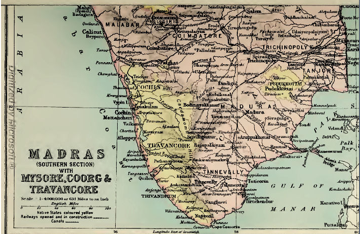
Native State in Southern India, lying between 11° 36° and 15° 2' N. and 74° 38' and 78° 36 E. It consists of an undulating table-land, much broken up by chains of rocky hills and scored by deep ravines.
Its form is that of a triangle, with the apex to the south, at the point where the Western and Eastern Ghāt ranges converge in the group of the Nīlgiris. The general elevation rises from about 2,000 feet above sea-level along the north and south frontiers to about 3,000 feet at the central water-parting which separates the basin of the Kistna to the north from that of the Cauvery to the south.
This watershed divides the country into two nearly equal parts, a little north of lat. 13° and as far as long. 77°, where a transverse line marks the eastern watershed. Several chains of hills, running chiefly north and south, subdivide the whole into numerous valleys, widely differing in shape and size.
Isolated peaks of massive rock, called 'droogs' (from Sanskrit durga, ' hill-fort '), rear their heads on all sides to an elevation of 4,000 or 5,000 feet above the level of the sea. The area of the State is 29,433 square miles. The greatest length north and south is about 230 miles; east and west about 290 miles. It is bounded by Madras Districts on all sides except on the north-west, where it is bordered by two Bombay Districts, and towards the southwest, where Coorg intervenes.
Name
The name is that of the capital, Mysore, for Maisūr (from mahisha, Sanskrit for 'buffalo,' reduced in Kanarese to maisa, and ūru, Kanarese [S. 162] for 'town' or 'country'), which commemorates the destruction of Mahishāsura, a minotaur or buffalo-headed monster, by Chāmundi or Mahishāsura Mardanī, the form under which the consort of Siva is worshipped as the tutelary goddess of the ruling family.
It is the Mahisa-mandala of Asoka's time, and forms the main part of the region called throughout Hindu literature Karnāta or Karnātaka, a term now wrongly applied to the districts below the Eastern Ghāts (see Carnatic).
Climate
The year in Mysore may be divided into three seasons : the rainy, the cold, and the hot. The first commences with the bursting of the south-west monsoon, generally early in June, and continues, with some interval in August and September, to the middle of November, closing with the heavy rains of what is popularly called the north-east monsoon. It is followed by the cold season, which is generally entirely free from rain, and lasts till the end of February.
The hot season then sets in during March, and increases in intensity to the end of May, with occasional relief from thunderstorms. The temperature is most agreeable during the rainy months, the range of the thermometer at Bangalore at that season being between 64° and 84°. In the cold season the mercury falls there as low as 51° in the early morning, and sometimes rises to 80° during the day. The minimum and maximum in the shade during the hottest months are about 66° and 91°, or in extreme seasons 96°.
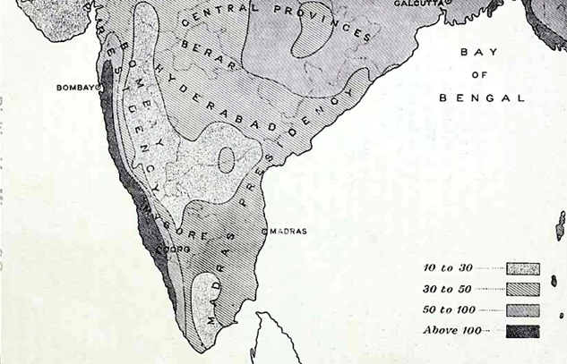
The annual rainfall ranges from over 360 inches on the crest of the Western Ghāts to as little as 19 inches in the north centre. But these are extremes that apply only to limited areas. The excessive rain of the Malnād rapidly diminishes eastwards, and from 20 to 37 inches may be accepted as the general annual average for the greater part of the State1.
The zone of heavy rain, 60 inches and over, is confined to the Western Ghāt region from Sorab to Manjarābād. From 40 to 60 inches of rain fall between Sorab and Shikārpur, in the Bābā Budans region, and in Heggadadevankote. The zone of 25 to 40 inches extends over all the remainder of the State, except Chitaldroog District, the north of Tumkūr and Kolār Districts, and the extreme south-east of Mysore District, which have less than 25 inches.
The distribution closely follows that of the forest belts, the heaviest rain coinciding with the evergreen belt, the next with the deciduous forest, and the least rainy tracts with the dry belt. [S. 168]
1.The mean annnal relative humidity of the Mysore State is set down by Mr. H. F. Blanford as 66. that of Malabar and Coorg being 79, and of the Carnatic 67. (Climates and Weather of India.) The cold-season rains, December to March, are insignificant, scanty, and not much needed for the standing crops. But they are useful in keeping up the pasture supply. The hot-season rains, in April and May, sometimes called mango showers, are of the accidental kind, and give heavy short storms from the east.
They are very important for agriculture, as a copious fail replenishes the tanks, and enables the cultivators to prepare the land for the ensuing monsoon. The southwest monsoon from June to September is perhaps the most essential for the country, which requires the steady drizzling rains of this season to make the soil productive. The north-east monsoon in October and November is essentially important for filling the tanks, and providing a store of water that may last over the rainless months.
A Meteorological department was formed in 1893, with observatories at Bangalore, Mysore, Hassan, and Chitaldroog, and having under its direction 203 rain-gauge stations.
The following table shows the average temperature and rainfall recorded at Bangalore, Mysore, and Chitaldroog for a period of years prior to 1901
Geography and geology
Two regions
Mysore is naturally divided into two regions of distinct character : the hill country, called the Malnād, on the west, confined to the tracts bordering or resting on the Western Ghāts (in Shimoga, Kadūr, and Hassan Districts) ; and the more open country in the east, known as the Maidān or Bayalshīme, comprising the greater part of the State, where the wide-spreading valleys and plains are occupied by numerous villages and populous towns. The Malnād is a picturesque land of mountain and forest, presenting the most diversified and beautiful scenery.
The various parts of the Maidān take their character from the means of water-supply and the prevailing cultivation. The level plains of black soil, in the north, grow cotton or millets ; the tracts in the south and west, irrigated by channels drawn from rivers, are covered with plantations of sugar-cane and fields of rice; those irrigated from tanks have gardens of coco-nut and areca palms ; the wide tracts of red soil, in the east, yield rāgi and other 'dry crops'; the stony and wide-spreading pasture grounds, in the central parts of the country, are stretches of coarse grass, relieved by shady groves of trees.
From the massive group of the Nīlgiris, which command the southern frontier, stretch forth, north-west and north-east respectively, the Western and Eastern Ghāt ranges, between which the plateau of Mysore lies like a wedge. The hills within this table-land, though rarely in continuous connected chains, arrange themselves into systems crossing the country longitudinally, in directions more or less parallel to the Ghāt ranges, according to their proximity to one or the other.
They attain their greatest elevation somewhat north of lat. 13°, where Mulainagiri (the highest point in Mysore), in the Bābā Budans, in the west, rises to 6,317 feet, and Nandidroog, in the east, to 4,851 feet. The best defined of the interior ranges is a belt, from 10 to 20 miles wide, running between 77° and 77° 30' E., from the Biligiri-Rangans (4,195 feet), through Sāvandurga (4,024) and Sivaganga (4,559), north up to Maddagiri (3,935), and on by Nidugal (3,772) to Molakālmuru and the frontier.
In the west a corresponding range, not more than 10 miles in width, runs north along meridian 75° 30' E., from Ballālrāyandurga (4,940 feet) beyond Shikārpur, having on its east the big loop of the Bābā Budans, whose peaks rise to over 6,000 feet. [S. 163] Intermediate between these two internal ranges is a chain, with considerable intervals between its component parts, trending to the east on the south of the central watershed, and to the west on the north of it.
Starting from the Wynaad frontier at Gopālswāmi Betta (4,770 feet), it passes by Nāgamangala to Chunchangiri (3,221), reappears to the west of Kibbanhalli in the Hāgalvādi hills (3,543), and crosses in a continuous belt through the middle of Chitaldroog District.
Of minor ranges the most important is that of Nandidroog, commencing near the hill of that name, with several peaks of nearly equal height, and passing north by Gudibanda to the Anantapur country. In the west a similar medial chain, but of lower elevation, runs from east of the Bābā Budans through Sakunagiri (4,653 feet), by the Ubrāni hills and Basavāpatna, along the right bank of the Tungabhadra to the frontier, where it meets that river.
The drainage of the country, with a slight exception, finds its way east to the Bay of Bengal, and is divisible into three great river systems : that of the Kistna on the north, the Cauvery on the south, and the Penner, Ponnayār, and Pālār on the east. The only streams flowing west to the Arabian Sea are those in the northwest, which, uniting in the Sharāvatī, hurl themselves down the Ghāts in the magnificent Gersoppa Falls ; and some minor streams which run down to South Kanara.
A line drawn east from Ballālrāyandurga to Nandidroog, and thence south to Anekal, with one from Devarāyadurga north to Pāvugada, will indicate approximately the watershed separating the three main river basins.
From the north of this ridge flow the Tunga and Bhadra, rising in the Western Ghāts and uniting in the Tungabhadra, which, after receiving the Hagari or Vedāvati, joins the Kistna beyond the limits of Mysore near Kurnool.
From the south, the Hemāvati (tributary the Yagachi), the Lokapāvani, Shimsha, and Arkāvati flow into the Cauvery, which rises in Coorg and takes a south-easterly course through the State, receiving also from the south the Lakshmantīrtha, the Kabbani or Kapila (tributaries the Nugu and Gundal), and the Honnuhole or Suvarnāvati.
From the east of the watershed, in the immediate neighbourhood of Nandidroog, spring three main streams :namely, the Uttara Pinakīni or Penner (tributaries the Chitrāvati and Pāpaghni), which runs into the sea at Nellore ; the Dakshina Pinakīni or Ponnayār, which reaches the sea at Cuddalore ; and between them the Pālār, whose mouth is at Sadras.
Owing to either rocky or shallow beds, none of these rivers is navigable in Mysore ; but timber is floated down the Tunga, the Bhadra, and the Kabbani at certain seasons. Most of the streams are fordable during the dry months, but during floods traffic over them is often suspended until the water subsides. Though useless [S. 164] for navigation, the main streams, especially the Cauvery and its tributaries, support an extensive system of irrigation by means of channels drawn from immense dams, called 'anicuts,' which retain the upper waters at a high level and permit only the overflow to pass down stream.
The channels or halves drawn from them meander over the country on either bank, following all the sinuosities of the ground, the total length maintained being upwards of 1,200 miles.
There are no natural lakes in Mysore ; but the streams which gather from the hill-sides and fertilize the valleys are embanked at every favourable point in such a manner as to form series or chains of reservoirs called tanks (Kanarese, kere), the outflow from one at a higher level supplying the next lower, and so on all down the course of the stream at a few miles apart.
These tanks, varying in size from small ponds to extensive lakes, are dispersed throughout the country to the number of nearly 30,000. The largest, Sūlekere, is 40 miles in circumference, but the Māri Kanave reservoir will exceed 90 miles. In the north-east are the spring-heads called talpargi, extending east of a line from Kortagere to Molakālmuru.
1.Granites and granitic gneisses, regarded as of Archaean age, occupy the greater portion of the State, and traversing these are metamorphic schists of Pre-Palaeozoic age. There are besides,
a.more recent acid, basic, and ultra-basic dikes, penetrating both the former systems, and irrupted probably not later than Lower Palaeozoic times ;
b.a deposit of laterite, widely distributed in extensive sheets or oftener in small isolated patches, forming an almost horizontal capping on the denuded surfaces of the older rocks ;
c.some relatively unimportant alluvial and sub-aerial deposits.
The schistose rocks which traverse the great complex of granite and granitic gneiss, and are more or less folded down into it, form three well-marked bands running in a generally north and south direction. Two are of large size, and are known respectively as the Shimoga and Chiknāyakanhalli bands, from their proximity to those towns.
The third is the Kolār band, very small in extent, but of the greatest economic importance. The two first named are southward extensions of the great bands in Dhārwār and Bellary2. The third is apparently an extension of a band running south along the Kadiri valley in Cuddapah, but a break of several miles appears to separate the two near the boundary line between Cuddapah and Mysore. [S. 165]
1 The earliest account of the geology of Mysore was by Captain Newbold in 1844-50 (see articles on the ' Geology of Southern India,' J.R. A. S., vols, viii, ix, xii). A State Geological department was formed under Mr. Bruce Foote in 1894, and is now under Dr. W. F. Smeeth, on whose notes this section is based. 2 See Bruce Foote's 'Geological Features of the South Mahratta Country,' 'Geology of the Bellary District,' and other papers (Memoirs, Geographical Survey of India, vols, xii, xxv; and Records, Geographical Survey of India, vols, xv, xxi, xxii).
The Shimoga band crosses the Tungabhadra near Harihar, extends to the southern boundary of Kadūr District, and spreads from near Kadūr on the east to the edge of the Western Ghāts on the west, where it forms much of the high Ghāt country culminating in the Kudremukh at an elevation of 6,215 feet. From this point the western boundary is probably continuous up to Anantapur (Shimoga District). West of Anantapur the country is covered by a great spread of laterite, beneath which gneiss is exposed in deep nullahs.
The Chiknāyakanhalli band runs through the middle of the State in a north-north-west and south-south-east direction. At the northern boundary it is divided into two horns by the great granite massif of Chitaldroog. Thence it runs south-south-west as far as Turuvekere n Tumkūr District, with an average width of about 18 miles.
Here it suddenly pinches ; and the only continuous extension southward is a narrow band, with an average width of 2 to 3 miles, running from Baichihalli to the Karigatta hill, north of the Cauvery, opposite the east end of the island of Seringapatam. A little to the west of this narrow band are several small strings of schist near Myasandra, Nelligere, and Nāgamangala, some of which appear to be dikes1. An important schist belt lying throughout the east of this band has been discovered, the rocks of which resemble those of the Kolār band. The southern extension towards Sivasamudram is rock containing 50 per cent. of iron.
The Kolār band lies on the eastern side of the State. It extends north and south for a distance of 40 miles, with a maximum width of 4 miles, while three narrow strings extend southwards into North Arcot and Salem. In general outline the main portion of the band may be regarded as consisting of a southern portion about 12 miles long by 4 miles wide, in which the present Kolār Gold Field is situated ; a northern portion about 12 miles long by 5 miles wide ; and a narrow neck of schist about 10 miles long by i mile wide, connecting these two parts. The band is composed essentially of hornblendic rocks, usually schistose, and some well-marked layers of ferruginous quartz rocks.
1 See Mysore Geological Department Records, vol. iii, plate i ; vol. ii, p. 82 ; vol. iii, p. 113. Granite exists in large irruptive masses, which have broken up and penetrated the older gneisses and schists. The gneisses so largely developed in Mysore are for the most part rocks of granitic composition, having a parallel-banded, wavy, or whorl-like structure, due to the arrangement of the lighter and darker constituents in more or less distinct bands or streaks.
They appear to be of igneous origin, rather than metamorphosed sedimentary rocks as suggested by Mr. Bruce Foote, the banding being due partly to segregation [S. 166] of the more basic constituents, and partly to the contemporaneous or subsequent veining by pegmatite, aplite, and other forms of granitic material. The prevailing type is a biotite-gneiss.
The Malnād or eastern face of the Western Ghāts is clothed with magnificent timber and contains the richest flora. The summits of the mountains are bare of trees, but covered with grasses and herbs—Anthisteria, Andropogon, Habenaria, &c.
The valleys descending from them are filled with woods called sholas, leaving grass-covered ridges between. Above 4,500 feet is the evergreen belt; lower down, to 3,000 feet, is a mixed belt, practically continuous ; and finally the deciduous trees are at the foot and throughout the plains. At extreme heights occur trees of the Nīlgiri flora, but smaller.
The South Indian tree-fern often ascends into the highest sholas, but rarer ferns abound in the mixed zone. It is here that coffee (Coffea arabica), pepper (Piper nigrum), and cardamoms (Elettaria cardamomum) are cultivated. Calophyllum tomentosum, Hardivickia binata, Bombax malabaricum, Vateria indica, Mesua ferrea, Myristica laurifolia, M. magnifica, Lagerstroemia lanceolata, L. Flos Reginae, Michelia Champaca, Ficus of many species, and Tectona grandis are some of the prominent trees in this belt, with the prickly bamboo (Bambusa arundinacea).
The Maidān or open plateau contains numerous species not found in the upper hill region. Bassia latifolia, Pterocarpus santalinus, Tamarindus indicus, Feronia elephantum, Mangifera indica, Artocarpus integrifolia, Acacia arabica, Pongamia glabra, Santalum album. Phoenix sylvestris, and Cocos nucifera are some of those characteristic of this part.
The hill ranges here and extensive areas in the plains are covered with small trees, shrubs, and twiners of various species, forming what is called scrub jungle. The main roads are lined with avenues of indigenous trees and the railroads with hedges of the aloe (Agave americana). Most villages have a grove (called a 'tope ') of common trees.
Population in 1901
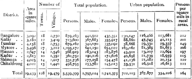
The table below gives details of the population of the State and its constituent Districts as returned at the Census of 1901
Taking the natural divisions of Malnād and Maidān, 17 per cent. of the area of the State and 12 per cent. of the population belong to the [S. 189] first, and the remainder to the second. The mean density is 185 persons per square mile. Mysore is the largest District, and contains the dynastic capital. Its total population is the highest, but in density of rural population it stands second. Bangalore District, the sixth in area, is second in total population and first in density of rural population. In it are situated the administrative capital of Mysore, and the Civil and Military Station with its large garrison, which is an Assigned Tract under British administration. The most populous tāluks are those watered by the Cauvery, with Bangalore and Anekal.
The urban population is 13 per cent. of the whole. Four places have been treated as cities in the Census of 1901 : namely, Mysore, Bangalore, the adjoining British Civil and Military Station, and the Kolār Gold Fields. The population of Bangalore (taking the city and the Civil and Military Station together) was 159,046, of Mysore city 68,111, and of the Gold Fields 38,204. Owing chiefly to plague, there had been since 1891 a loss of 21,320 in Bangalore and of 5,937 in Mysore, while, in spite of plague, the Gold Fields gained 31,119. The number of towns is 124, of which Mysore, Tumkūr, and Bangalore Districts contain 26, 18, and 16 respectively, and Kolār and Kadūr only 11 and 10.
A town is a municipality of whatever size, or a place not absolutely rural containing a population of 5,000 and above. Only five of these towns have a population exceeding 10,000—Kolār, Tumkūr, Channapatna, Dāvangere, and Tarikere—while the population of twenty-seven lies between 5,000 and 10,000, of which eight belong to Mysore and five to Bangalore District. The inhabited villages number 16,884. In the Maidān a village may have dependent hamlets grouped with it.
In the Malnād, villages are often such only in name, being composed of scattered homesteads at various distances apart. The towns and villages vary little as regards the main occupations and habits of life of the people, but those which are also market places or tāluk headquarters become centres of trade and home industries. The number of houses per square mile rose from 25 in 1881 to 37 in 1901, and the occupants per house averaged 5 at the latter date as compared with 5-6 twenty years before.
The variation in total population at each Census has been : (1871) 5,055,102,(1881)4,186,188, (1891) 4,943,604, and (1901) 5.539.399. The fall in 1881 was due to the great famine of 1876-8, but was almost compensated by the rise in 1891. In spite of plague, the last Census shows a marked general increase of 12 per cent. The rise has been greatest in Kolār and Chitaldroog Districts, and least in Kadūr, the population of which has scarcely varied. The increase in the Districts of Mysore, Hassan, and Shimoga is below the average.
In 1901, according to the census returns, 306,381 persons enumerated [S. 190] in the State had been born out of it, and 132,342 born in the State were registered elsewhere. The greatest increase of foreign immigrants is of course in Kolār, in connexion with the gold-mines. But all the Districts show an increase under this head, especially Hassan and Kadūr, which are coffee-growing tracts.
The percentage distribution of the total population under different age periods is as follows : 13.03 of ages 0 to 5 ; 26.87 of 5 to 15 ; 22.01 of 15 to 30; 20.63 of 30 to 45 ; 11.93 of 45 to 60; and 5.51 of 60 and over. Females are in a total ratio of 981 to 1,000 males, but they exceed males at ages 3 to 4, 20 to 35, 50 to 55, and at 60 and over.
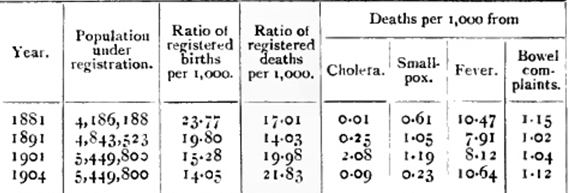
Except in Bangalore city and Civil and Military Station, and in Mysore city, vital statistics cannot be accepted as reliable ; and even in those places it is chiefly since the outbreak of plague in 1898 that particular attention and scrutiny have been given to them, with special reference to the number of deaths.
In other parts the pātel or headman has to keep up the register, under the control of the revenue officers ; but as there is no obligation on householders to report domestic occurrences, he can hardly be held responsible for the accuracy of the returns.
The following table is compiled from such statistics as are available, but the numbers of both births and deaths are manifestly understated
For the decade ending 1901, Chitaldroog and Mysore show the highest and lowest birth-rates respectively, and Shimoga and Tumkūr the highest and lowest death-rates.
There were 1,025,838 cases treated in the hospitals and dispensaries of the State in 1901, of which 46 per cent. were those of men, and the rest of women and children in the proportion of about 2 to 3. The diseases treated are classed as general or local, 42 per cent. belonging to the former class. Of these, the most numerous were malarial fevers, worms, rheumatic affections, debility and anaemia, and venereal diseases. Of local, the greater number were diseases of the skin, the digestive system, the eye, the lungs, and injuries.
Plague first appeared in August, 1898, at Bangalore, being imported by rail from Dhārwār. By the end of June, 1904, it had claimed 106,950 victims in the whole State, out of 141,403 cases of seizure. In [S. 191] other words, 2.5 per cent. of the population were attacked by plague, and of those attacked nearly 76 per cent. died. The figures for each year show a large decrease in 1899-1900 and a rise since. With 1903-4 the numbers are again going down.
The temporary decrease in the second year was probably due to extensive exodus to other parts, a drier season owing to deficient rainfall, general inoculation, and enforcement of passport regulations. Special restrictions have since been virtually withdrawn ; but evacuation of infected places, general or local disinfection by chemicals or desiccation, and the opening out of congested parts are in operation1. No place has suffered more than Mysore city, where 17 per cent. of the deaths have occurred.
A regulation was passed in 1903 appointing a special board for the improvement of the city. Shimoga and Kadūr Districts were free till 1900, and Chitaldroog District had no deaths from plague in that year. The disease seems to be at its maximum about October, and at its minimum about May, these being respectively the wettest and driest months in the year. 1 Large extensions have been added to Bangalore city, and a new town on modern lines has been laid out at the Kolār Gold Fields.
The figures obtained at the Census of 1901 are a gauge of the infant mortality occasioned by the famine of 1876-8, and by the unhealthy years, culminating in plague, of the decade ending 1901.
The following table gives the ratio of infants of either sex to 1,000 of the same sex
The proportion of females to 1,000 males in the whole State in 1901 was 981, the figures for the urban population being 963, and for the rural 983. In 1871 the proportion was 994, in 1881 it was 1,007, and in 1891 it was 991. The relative number of females has thus fallen considerably in the thirty years.
Hindus exceeded the general average at each Census. Christians had the fewest females in the three previous census years, and in 1901 this position was held by the Jains. Females exceed males in Mysore and Hassan Districts (1,020 and 1,010), and are most in defect in Shimoga and Kadūr (918 and 908). In the Civil and Military Station of Bangalore the ratio is 986, in Mysore city 984, in Bangalore city 931, and in the Kolār Gold Fields only 699, as might be expected. Since 1891 males have increased by 12.6 per cent. and females by 11.4.

