Benares Division
This article has been extracted from THE IMPERIAL GAZETTEER OF INDIA , 1908. OXFORD, AT THE CLARENDON PRESS. |
Note: National, provincial and district boundaries have changed considerably since 1908. Typically, old states, ‘divisions’ and districts have been broken into smaller units, and many tahsils upgraded to districts. Some units have since been renamed. Therefore, this article is being posted mainly for its historical value.
Benares Division
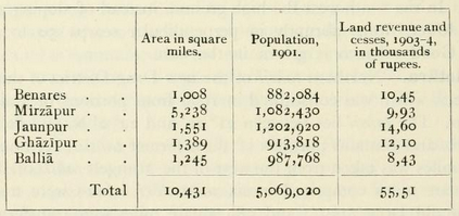
South-eastern Division of the United Provinces, lying between 23° 52' and 26 12' N. and 82° 7' and 84° 39' E, The northern portion is traversed by the Ganges and in the east reaches to the Gogra, while the southern extends beyond the Kaimur range and the river Son to the East Satpuras. The head-quarters of the Commissioner are at Benares city. Population increased from 1872 to 1891, but fell during the next decade. The numbers at the last four enumerations were as follows: (1872) 4,395,252, (1881) 5,178,005, (1891) 5,368,480, and (1901) 5,069,020. There is reason to believe that the Census of 1872 understated the actual population. The decrease between 1891 and 1901 was due partly to an epidemic of fever following disastrous floods in 1894, partly to emigration, and partly to the effects of famine. The total area is 10,431 square miles, and the density is 486 persons per square mile, as compared with 445 for the Provinces as a whole. The Districts north of the Ganges include the most thickly populated area in the United Provinces. In 1901 Hindus formed more than 91 per cent, of the total population, and Musalmans not quite 9 per cent. There were 2,949 Christians and 1,984 Sikhs. The Division contains five Districts, as shown below :
This is the only considerable area in the United Provinces of which the revenue is permanently settled. Ballia District lies entirely in the Doab between the Ganges and Gogra, which form its northern and southern boundaries and meet at its eastern extremity. Jaunpur District is situated in the same Doab, but does not reach either of the rivers. Ghazlpur, Benares, and Mirzapur lie on both sides of the Ganges ; but while the first two Districts are situated entirely in the alluvial plain, Mirzapur stretches many miles south to the Vindhyas and East Satpuras. There are 13,654 villages and only 38 towns ; and the Division is remarkable for the number of small hamlets in almost every village, contrasting with the closely-packed central village sites of the Western Districts in the United Provinces. The largest towns are : Benares (population, 209,331 with cantonments), Mirzapur (79,862), Jaunpir (42,771), and Ghazipur (39,429). There are few places of commer- cial importance, the chief being Benares, Mirzapur, Ghazipur, Jaunpur, Shahganj, and Ahraura. Benares is one of the holiest centres of Hinduism, especially to the worshipper of Siva ; and some interesting Buddhist remains have survived at Sarnath near it. Jaunpur was the seat of a powerful kingdom during the fifteenth century, and con- tains fine specimens of the Muhammadan buildings of that period.
