National Capital Region (India): The Region
m (Protected "National Capital Region (India): The Region" ([edit=sysop] (indefinite) [move=sysop] (indefinite))) |
|||
| (One intermediate revision by one user not shown) | |||
| Line 13: | Line 13: | ||
==The source of this article== | ==The source of this article== | ||
| − | + | [[File: region1.PNG||frame|500px]] | |
| + | [[File: region2.PNG||frame|500px]] | ||
| + | [[File: region3.PNG||frame|500px]] | ||
| + | [[File: region4.PNG||frame|500px]] | ||
''' Draft Revised Regional Plan 2021: National Capital Region ''' | ''' Draft Revised Regional Plan 2021: National Capital Region ''' | ||
| Line 27: | Line 30: | ||
= National Capital Region (India): The Region= | = National Capital Region (India): The Region= | ||
| − | + | == CONSTITUENT AREA== | |
The National Capital Region includes NCT-Delhi, nine districts of Haryana, six districts of Uttar Pradesh | The National Capital Region includes NCT-Delhi, nine districts of Haryana, six districts of Uttar Pradesh | ||
| Line 62: | Line 65: | ||
[[File: region.PNG||frame|500px]] | [[File: region.PNG||frame|500px]] | ||
| − | + | ==PHYSICAL SETTING== | |
The National Capital Region lies between 27o 03' and 29o 29' North latitude and 76o 07' and 78o 29' East | The National Capital Region lies between 27o 03' and 29o 29' North latitude and 76o 07' and 78o 29' East | ||
| Line 76: | Line 79: | ||
Capital Region: Physiography and Slope). | Capital Region: Physiography and Slope). | ||
| − | + | == GEOLOGY== | |
The rock type exposed in the area belongs to Delhi Super-group of Lower Proterozoic age and consists of | The rock type exposed in the area belongs to Delhi Super-group of Lower Proterozoic age and consists of | ||
| Line 95: | Line 98: | ||
south-east as a series of isoclines (Map 2.3 National Capital Region: Lithology). | south-east as a series of isoclines (Map 2.3 National Capital Region: Lithology). | ||
| − | + | == GEOMORPHOLOGY== | |
Topographically the NCR has two major sub-units. The alluvial plains whose monotony is intercepted by | Topographically the NCR has two major sub-units. The alluvial plains whose monotony is intercepted by | ||
| Line 127: | Line 130: | ||
| − | + | ==RIVER SYSTEM== | |
NCR is drained by three perennial rivers viz. the Ganga, the Yamuna and the Hindon. The Ganga forms | NCR is drained by three perennial rivers viz. the Ganga, the Yamuna and the Hindon. The Ganga forms | ||
| Line 142: | Line 145: | ||
ephemeral stream in the area is Ruparch which is in the extreme south of the area falling in Alwar district. | ephemeral stream in the area is Ruparch which is in the extreme south of the area falling in Alwar district. | ||
| − | + | == GROUND WATER== | |
The quartzite and its associated rocks of the Delhi series are traversed by joints and are folded, faulted | The quartzite and its associated rocks of the Delhi series are traversed by joints and are folded, faulted | ||
| Line 152: | Line 155: | ||
aquifer have the same static water level surface because of their interconnections. The details about | aquifer have the same static water level surface because of their interconnections. The details about | ||
ground water in NCR have been elaborated in the Chapter 8 of the Regional Plan. | ground water in NCR have been elaborated in the Chapter 8 of the Regional Plan. | ||
| − | |||
| − | |||
| − | |||
| − | |||
| − | |||
| − | |||
| − | |||
| − | |||
Latest revision as of 21:37, 16 March 2014
This article has been sourced from an authoritative, official readers who wish to update or add further details can do so on a ‘Part II’ of this article. |
Contents |
[edit] The source of this article
Draft Revised Regional Plan 2021: National Capital Region
July, 2013
National Capital Region Planning Board, Ministry of Urban Development, Govt. of India, Core-4B, First Floor, India Habitat Centre, Lodhi Road, New Delhi-110003
National Capital Region Planning Board
[edit] National Capital Region (India): The Region
[edit] CONSTITUENT AREA
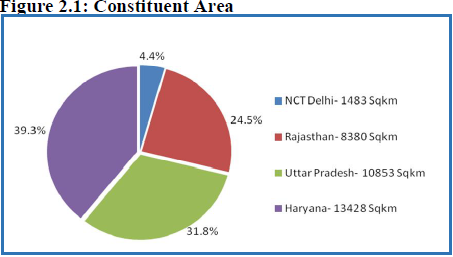
The National Capital Region includes NCT-Delhi, nine districts of Haryana, six districts of Uttar Pradesh and one district of Rajasthan. Total area of the region is 34,144 sq. km. (Map 2.1 National Capital Region Regional Plan-2021: Constituent Areas). Subsequent to the preparation of the Regional Plan-2021, a few districts were bifurcated and reorganized by the participating States. The current administrative units and their land areas are as follows (Figure 2.1):
a) National Capital Territory of Delhi (1,483 sq. km.) accounting for 4.4% of the total area of NCR.
b) Haryana Sub-Region with an area of 13,428* sq. km. accounting for 30.3% of the area of the State
and 39.3% of the area of NCR comprising following nine districts:
i) Faridabad vi) Jhajjar
ii) Gurgaon vii) Rewari
iii) Rohtak viii) Mewat
iv) Sonepat ix) Palwal
v) Panipat
c) Rajasthan Sub-region comprises Alwar district
which has an area of 8,380** sq. km. This
account for 2.5% of the total area of the State
and 24.5% of the area of NCR.
[edit] PHYSICAL SETTING
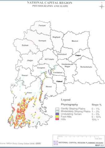
The National Capital Region lies between 27o 03' and 29o 29' North latitude and 76o 07' and 78o 29' East longitude. The physiography of the region is characterized by the presence of the river Ganga skirting it as its eastern boundary, the river Yamuna traversing north-south forming the boundary between Uttar Pradesh and Haryana, and the sand dunes and barren low hills of the Aravalli chain and its outcrops in the west, flat topped prominent and precipitous hills of the Aravalli range enclosing fertile valleys and high table lands in the south-west, and the rolling plains dominated by rain-fed torrents in the south.
The rest
of the region is plain with a gentle slope from north-east to south and south-west. (Map 2.2 National
Capital Region: Physiography and Slope).
[edit] GEOLOGY
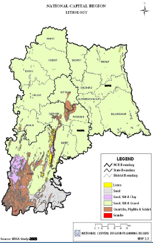
The rock type exposed in the area belongs to Delhi Super-group of Lower Proterozoic age and consists of Quartzite of the Alwar Group, Phyllite and Slate of the Ajabgarh Group. The Quartzites are massive,
thickly bedded, hard, compact and highly jointed and are intercalated with thin beds of Phyllite and Slates.
The strike of the beds is NNE-SSW and dip westerly at moderate angles. These rocks are mostly covered by
quaternary sediments and are exposed in isolated residual and structural hills and pediments.
Note: * Increase in area of Haryana Sub-region is due to reorganization of Panipat district as per Statistical Abstract, Haryana.
- Area of Rajasthan Sub-region is as per letter dated 24.5.2013 from the Government of Rajasthan.
These hills are exposed in south and south-west of Delhi at Delhi, Gurgaon, Rewari and Alwar. The rocks
near Delhi consist of narrow strike-ridges and are moderately folded and they are over-folded in the
south-east as a series of isoclines (Map 2.3 National Capital Region: Lithology).
[edit] GEOMORPHOLOGY
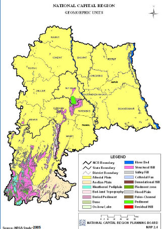
Topographically the NCR has two major sub-units. The alluvial plains whose monotony is intercepted by isolated hillock or fairly continuous ridges of hard rock and sand dunes not more than 50 metres in elevation from the plain lands surrounding them. NCR terrain around Delhi, Haryana and U.P. constitutes such a plain. Sand dunes are prominent in parts of Haryana and Rajasthan and hard rock ridges bending NE to SW is seen in south and south-west of NCR covering good parts of the Alwar district and Delhi
(Map 2.4 National Capital Region: Geomorphic Units). The Ganga Sub-basin is a major part of the Ganga, the largest river basin in India. The watershed of the Ganga covers almost the entire northern India including Yamuna basin. A clear watershed line divides the area between Ganga basin and Yamuna basin within NCR. The topography of the main Ganga river system varies from rugged hills of the Himalayas to the alluvial plains. The soil generally consists of alluvium deposits in the Gangetic plains. The Yamuna river system is bounded by the Himalayas on the north and the Vindhyas on the south. In the east, it is separated by the ridge from the main Ganga catchment and on the west by the ridge separating it from the Luni and the Ghaggar basins. Most parts of catchment in Haryana and U.P. lies in the Gangetic alluvial plains.
The important tributary of the Yamuna in NCR is the Hindon, which rises from southern slopes of the Shivalik in Saharanpur district of U.P. and ultimately meets the Yamuna from the left downstream of Okhla. The other tributary which is not having a defined course is the Sahibi river, which rises from the hills in Jaipur district of Rajasthan and after flowing through Haryana enters NCT of Delhi through Dhansa Bund into Najafgarh Jheel and then joins the Yamuna in NCT of Delhi. The paleo-channels are confined in between the Ganga and the Yamuna courses in the eastern and the central part of the area.
Prominent structural hills in NCR are noticed around Delhi, Rewari, Gurgaon and Alwar. The residual hills are found in and around Rewari, Alwar and Delhi. The alluvial plain occupies a major portion of NCR and is formed by the Yamuna and the Ganga rivers. The sand dunes are present around Jhajjar and Rohtak in the western part of NCR.
[edit] RIVER SYSTEM
NCR is drained by three perennial rivers viz. the Ganga, the Yamuna and the Hindon. The Ganga forms the easternmost boundary of the area and flows southerly direction for the entire length of the area. The Yamuna forming a boundary between Haryana and Uttar Pradesh also flows southerly direction and almost bisects the area.
Hindon river also flows in southerly direction. There are many other small streams falling in U.P. viz. Karavan Nadi, Kali Nadi, Nim Nadi, all flowing towards south. The southern and south-western parts of NCR area is devoid of perennial river. The line of natural drainage in this part is from south-west to north-east or north namely Sahibi Nadi, which is ephemeral, enters the area at about 5 kms. south of Behror in Alwar district in Rajasthan. It flows in a north-east direction towards Rewari, in Haryana. It carries away the water of the western slope of the central range of Aravalli hills. Another ephemeral stream in the area is Ruparch which is in the extreme south of the area falling in Alwar district.
[edit] GROUND WATER
The quartzite and its associated rocks of the Delhi series are traversed by joints and are folded, faulted and fractured. The joints persists deeper down often to about 100 metres depth, which is the maximum depth to which most of the tube wells to date exist. The joints and fractures are open, often filled with debris and mutually interconnected; cavities created by the erosion of mica-schist add to the secondary porosity developed by these joints and fractures. Ground water occurs in the consolidated rocks both in confined and semi-confined conditions. Mostly the top water table zone and the deeper semi-confined aquifer have the same static water level surface because of their interconnections. The details about ground water in NCR have been elaborated in the Chapter 8 of the Regional Plan.


