Manipur (Home page)
This is a collection of articles archived for the excellence of their content. Readers will be able to edit existing articles and post new articles directly |
Contents |
The source of this article
INDIA 2012
A REFERENCE ANNUAL
Compiled by
RESEARCH, REFERENCE AND TRAINING DIVISION
PUBLICATIONS DIVISION
MINISTRY OF INFORMATION AND BROADCASTING
GOVERNMENT OF INDIA
MANIPUR: the basic facts
Area : 22,327 sq km
Population : 22,93,896 (2001 Census)
Capital : Imphal
Principal Language : Manipuri
Manipur: INTRODUCTION
Manipur Tourism
Manipur, fondly called by Pandit Jawaharlal Nehru as the “Jewel of India”, is a little Shangrila located in a lush green corner of North-East India between 23.83° & 25.68° North latitudes and 93.03° & 94.78° East longitudes. An oval shaped valley surrounded by nine ranges of bluish-green hills intertwined with cascading rapids, tripping rivers, carpets of flowers, exotic blooms and lazy lakes, she has inspired descriptions such as the “Switzerland of the East”. One of the most profound observations was made by Lady St.Clair Grimwood, author of ‘My Three Years in Manipur’ who described her as ‘A pretty place more beautiful than many snow places of the world’.
Sharing an international border with Myanmar, the state has a strategic importance in India’s Look East Policy and is set to become the Gateway to South- East Asia and an important tourist destination in the near future. The people of Manipur include Meities, Nagas, Gorkhas, Meitei Pangals, Kuki - Chin - Mizo groups and many other colorful communities who have co-existed in complete harmony over the centuries. These are people whose folklore, myths and legends, dances, indigenous games and martial arts, cuisines, exotic handlooms and handicrafts are invested with the mystique of nature and an indefatigable Joie de vivre.
HISTORY AND GEOGRAPHY
Manipur has a long and glorious history from before the beginning of the Christian era. The political history of Manipur started from 33 A.D. with the coronation of Nongda Lairen Pakhangba. After Pakhangba a number of kings ruled over the kingdom of Manipur. The independence and sovereignty of Manipur remained uninterrupted until the Burmese invaded and occupied it for approximately seven years in the first quarter of the 19th century (1819-1826). Then, Manipur came under British Rule on 27 April 1891.
Manipur regained its independence in 1947 and merged into Indian Union on 15th October 1950. Thus, it became a Part C State under a Chief Commissioner. During 1950-51, an Advisory form of Government was introduced and in 1957 this was replaced by a Territorial Council of 30 elected and 2 nominated members. Later, in 1963 a Territorial Assembly of 30 elected and 3 nominated members was established under the Government of Union Territories Act, 1963.
The status of administrator was raised from that of a Chief Commissioner to that of a Lt. Governor in December 1969. Manipur became a full-fledged State on 21st January 1972 with a Legislative Assembly of 60 members of whom 19 are reserved for Scheduled Tribes and one for Scheduled Castes. The State is represented in the Lok Sabha by two members and by one member in the Rajya Sabha.
Manipur is situated in the extreme north-eastern border of India. It is bounded on the east by upper Myanmar, on the north by Nagaland, on the west by Cochar District of Assam and on the south by Chin Hills of Myanmar and Mizoram. Manipur has a total border line of about 854 kms. of which about 352 kms. are international boundary line with Myanmar on the east and south-east. This State can claim a geographically unique position, since it virtually is the meeting point between India and South-East Asia. Manipur lies between 23.800 N and 25.680 N latitude and between 93.030 E and 94.780 E longitude.
The State has a total area of 22,327 sq. kms. There is a small oval shaped plain in the central part. This central plain known as Imphal Valley is at a height of about 790 metres above MSL. This valley is surrounded by hills on all sides. The hill covers about 9/10 of the total area of the State. The hill ranges are higher on the north and gradually diminish in height towards the south. The valley itself slopes down towards the south.
AGRICULTURE
Agriculture and allied activities are the only mainstay of the State’s economy where about 70 per cent of the population depends on it. The State has two topographical zones — valley and hills. The valley is known as the 'Rice Bowl' of the State. The valley has sub-tropical to tropical to sub-temperate climate. The hills have subtemperate to temperate climate with an average altitude of 3000 metres above MSL.
The State has distinct winter, warm, humid and rainy summer. The average rainfall covering the State is 1436 mm. It occurs mainly during June to September when the State is under the spell of South West Monsoon. The growth of agriculture in the State has been quite uneven and unsatisfactory for the reason that its production still depends on seasonal rainfall.
FORESTS
According to the State Forest Report, 2009 prepared by Forest Survey of India, Dehradun, the forest cover in the State is 17,280 sq. km, which is 77.40% of the State's geographical area. In terms of forest canopy density classes, the State has 701 sq. km. very dense forests, 5474 sq. km. moderately dense forests and 11.105 sq. km. open forests. Comparison of the current forest cover with the previous assessment in 2005 shows an overall increase in forest cover of 328 sq. km. This overall increase in forest cover is mainly due to regeneration in abandoned jhum areas.
IRRIGATION
Major and Medium lrrigation had been introduced in the State since 1980. So far 8 (eight) Major and Medium Irrigation & Multipurpose Projects have been taken up of which 5 (five) projects viz. Loktak Lift Irrigation Project, Khoupum Dam Project, Imphal Barrage Project, Sekmai Barrage Project and Singda Multipurpose Project were completed by the end of 8th Plan. By the end of Eighth Plan period, only about 67,546 ha. has been brought under irrigation of which Major and Medium irrigation projects contributed 28,150 ha. and Minor Irrigation contributed 39,396 ha.
COMMERCE & INDUSTRIES
The Handloom industry is by far the largest and most important cottage industry in Manipur. As per National Handloom Census, 1995-96 report conducted by the National Council for Applied Economic Research, New Delhi, Manipur has 4.62 lakh handloom workers which is 2nd position among the States, 2.81 lakh looms which is 4th position, consuming 12.196 lakh kg of yarn per month which is 7th position and produced 96.07 lakh metres of handloom fabrics which is also 7th among States of the country.
POWER
Power Supply in Manipur is fully dependent on the Central Generating Stations situated in the North Eastern Region (NER). Peak demands for night and day are of the order of 150 & 100 MW in summer and 170 & 110 MW in winter. As the generating stations in the NER are mainly of hydel in nature, during lean period there is a shortfall in generation and therefore the available share of Manipur reduces drastically.
ART AND CULTURE
Its own art-forms and cultural expressions and ramifications distinctly showcase Manipur to the world. Its famous classical dance remains unique in all Manipuri dance-forms whether it is folk, classical or modern and has different style and gesture of movement.
TRANSPORT
Roads: Road Transport is the only means of communication for development of the State as there are no inland Waterways, Railways or Ropeways. All development activities depend entirely on the road transport facilities.
The total length of roads in Manipur by 2009 including National Highways, NEC, BRTF and Roads under Rural Development, was 12618 km. Out of the total road length, the surfaced length in 5443 km.
3 National Highways : i) NH-39, ii) NH-53 and iii) NH-150 criss-cross the State connecting all Districts. Imphal the capital of Manipur is joined by NH-39 with Nagaland on the north and Myanmar on the east, on the west with Assam by NH-53 and Mizoram on the south by NH-150.
Aviation: Imphal Airport is the second largest airport in the North Eastern Region. Imphal is connected to Aizwal, Guwahati, Kolkata, Silchar, Bangaluru and New Delhi by Air India, JetLite, Indigo and Kingfisher Airlines.
Imphal Airport is being upgraded to international status. The Construction of infrastructure for Night Landing Facility at Imphal airport has been completed and Air India has started Night Flights to and from Imphal.
Railways: The State is included in the railway map of India with the opening of a rail head at Jiribam in May 1990. It is 225 km from Imphal. Dimapur (Nagaland), 215 km from Imphal is the nearest rail-head.
The Jiribam - Tupul - Imphal Railway line has been declared as a National Project. Construction of the Line is in good progress and is targeted for completion by 2014 (upto Tupul) and 2016 (upto Imphal).
FESTIVALS
A year in Manipur represents a cycle of festivals. Hardly a month passes by without a festival which to the Manipuris is a symbol of their social, cultural and religious aspirations. Important festivals of the State are : Lai Haraoba, Rasa Leela, Cheiraoba, Ningol Chak-Kouba, Rath-Jatra, Idul Fitre, Imoinu Iratpa, Gaan-Ngai, Lui-Ngai- Ni, Idul Zuha. Yaoshang (Holi), Durga Pujah, Mera Houchongba, Diwali, Kut, Christmas, etc.
TOURIST CENTRES
Manipur is not only the gateway of the North Eastern region but is also a fascinating destination for discerning tourists. Blessed with a salubrious climate, natural beauty and scenic splendour, the state extends to the tourists a warm welcome. Some important tourist centres in the State are : Kangla, Shree Shree Govindajee Temple, Khwalramband Bazar (Eema/ Ima Keithel), War Cemeteries, Shaheed Minar, Nupi Lan (Women's War) Memorial Complex, Khonghampat Orchidarium, INA Memorial (Moirang), Loktak Lake, Keibul Lamjao National Park, Sendra, Moreh, Siroy Hills, Dzuko Valley, State Museum, Kaina Tourist Home, Khongjom War Memorial Complex, India Peace Memorial (Red Hill) etc.
GOVERNMENT
Governor : Shri Gurbachan Jagat
Chief Secretary : Shri D.S. Poonia, IAS
Chief Minister : Shri O. Ibobi Singh
Jurisdiction of High Court: A permanent bench of the Guwahati High Court, Imphal Bench started functioning from 14th March 1992. The Chief Justice of India laid foundation stone for construction of a new High Court Complex on 30th April 2006 and construction of the complex is in good progress & targeted to be completed within this year.
AREA, POPULATION AND HEADQUARTERS OF DISTRICTS
S.N. District Area Population Headquarters (Census 2001)
1. Senapati 3,271 2,83,621 Senapati
2. Ukhrul 4,544 1,40,778 Ukhrul
3. Chandel 3,313 1,18,327 Chandel
4. Churachandpur 4,570 2,27,905 Churachandpur
5. Tamenglong 4,391 1,11,499 Tamenglong
6. Imphal (West) 519 4,44,382 Lamphelpat
7. Imphal (East) 709 3,94,876 Porompat
8. Thoubal 514 3,64,140 Thoubalpat
9. Bishnupur 496 2,08,368 Bishnupur
Total 22,327 22,93,896
PLACES 'OPEN' IN RESTRICTED/ PROTECTED AREA
(In Indian English this means: Here is a list of places that you can visit though they are otherwise located within Manipur's RESTRICTED/ PROTECTED AREAS.)
VISIT PERMITTED TO
Loktak Lake, Imphal, Moirang INA Memorial, Keibul Deer Sanctuary and Waithe Lake Kongiam War Memorial
AUTHORITY (The authority that will give you the permission to visit these places)
All Indian Missions abroad
All FRROs & MHA (Minsitry of Home Affairs)
State Government of Manipur
REMARKS
Individual tourists not permitted, 6 days allowed
Calcutta to Imphal by air only
Foreigners allowed only in groups of 4 or more. 10 days.
Entry by road allowed on NH39 & NH53 for Dimapur-Kohima-Imphal-
Jiribam-Silichar
ADDITIONAL AREAS OPENED UP
(I.e. places that tourists can visit)
Imphal-Bishnupur-Phubala-Moirang-Sendra-Keibul-Lamjao-Imphal
Imphal-Moirang Lake-Keibul-Lamjao-Chur-Chanderpur-Khuga-Imphal
Imphal-Litan-Ukhral-Shiroy-Sangsak-Imphal
Imphal-Thoubal-Waithou Lake-Khongjam-Kakching-Thongjao-Waikhong- Sugnu-Imphal
Imphal-Khonghampat-Kanglatombi-Kangpokpi-Senapati-Karong-Mao Gate-Imphal
Imphal-Nonoh-Khongsang-Nungba-Jiribam-Imphal
The strengths of Manipur
(This is a crowdsourced section sent by Palin Khundongbam, based on contributions from various Manipuris.) Additional inputs by Jugindra Sorokhaibam
1. India's Look East Policy (LEP) was initiated through Manipur initially.
2. Land, lake (Loktak) and hills
3. Bordering with Myanmar
4. Educated youths High literacy
5. International airport
6. Meeting point of 2 superpower nations India and China
7. ASEAN highways 1 and 2 pass through Manipur.
8. War tourism destinations because of greatest battle of Imphal (see World War II in Northeast India)
9. Art and culture [inc Manipuri classical dance]
10. Railhead.
11. Sports [Along with Haryana a sporting powerhouse] (See Mary Kom )
12. State which probably gave the world the game of Polo
13. 2 Medical Colleges
14. National Institute of Technology
15. Human resources
16. English speaking
17. Eema Keithel (See Imphal: Keithel, Khwairamband Bazaar)
18. Enough rainfall for harvesting
20. Highly fertile land (not desert)
21. Enough hill area for forestation and cultivation of tea, horticulture, sericulture etc
22. High respect to women (lower female foeticide in Manipur)
23. Manipur University
24. IT talent of Manipuri
25. Manipuri human Resources residing outside the state and outside India.
26. Large number of Manipuri nurses working in leading Hospitals of India.
27. Good number of specialist and super specialists doctors in the state (See Manipur: Hospitals/ Medical Tourism)
28. Many totally amputated hands re-implanted
29. Siroy Lilly
30. Sangai
31. Orchids
32. Theatre for art and drama
33. Adventure tourism
34. Waterfalls
35. Unique food items
36. Kangla
37. Rural home stay can be promoted.
38. Underground water
39. Medicinal plants (See Manipur: Flora & Fauna; Manipur: Forests; Manipur: Birds)
40. Central Agricultural University
41. Bamboo culture.
42. Classic (a 3 Star hotel)
43. Vibrant film and pop industry (See Manipuri Cinema)
44. Two Guinness World Records ( a. Mr. Okendro for 'culturing' tallest plant pf one type , Samballei Sekpil. b. Dr. Palin Kh and his team of Shija Hospitals for successful excision of the largest neck tumour, 40% of the total body weight)
45. Institute of Cooperative Management
46. Huge participation in hospitality industry in India.
47. National Accreditation Board of Laboratory, NABL. Lab Babina
48. National accreditations Board of Hospitals and Healthcare provider, NABH. Shija Blood Bank. 1st in NE India.
49. Nucleic Acid Test (NAT) at Shija Blood Bank to detect HIV HCV AND HBV EARLIEST, 1st in Eastern India.
50. Manipuri script.
51. Comfortable weather
52. Fermented Food Technology
53. Handloom Products
54. Kauna Handicraft Products
55. Mukna and other indigenous sports
56. Thang-ta / Sajan Martial Arts
58. Bio-waste to Energy/ Bio-fertilizer for environmental sustainability
60. Most delicious plums, pineapples and oranges
61. Sinju: This is a unique and indigenous form of mixed salad. It is distinctively Manipuri considering the variety of ingredients used.
62. Mountaineering experience of Manipur
63. Arts and Culture Institute - A call from Aribam Syam Sharma
Militancy in Manipur
SOURCE: INSTITUTE FOR CONFLICT MANAGEMENT
Jun 05 2015
Manipur merged with India under duress, say rebels
What's the root cause of militancy in Manipur? A section of Meiteis (that's how Manipuris address themselves) want their state's independence from India. They reject Manipur's merger with the Indian Union on October 15, 1949, as an agreement signed under duress from New Delhi.What are the major insurgent outfits?
Anti-merger sec tions have set up six underground outfits: People's Liberation Army , United National Liberation Front, LE People's Revolutionary Party of KangleiTH pak, People's Revolutionary Party of Kangleipak (Progressive), Kangleipak Communist Party and Kanglei Yawol Kane Lup (Organisation to Save Kanglei Revolutionaries). Kangleipak is Manipur's old name. These groups, active mostly in the Meitei-dominated Imphal Valley, have formed a coordination committee popularly known as CorCom. In the hill districts, two Naga outfits, National Socialist Council of Nagalim (Isak-Muivah) and Nation al Socialist Council of Na galand (Khaplang) are ac tive. They want Naga-dominated areas of Manipur to be part of the proposed Nagalim (Grea ter Nagaland). Besides, Ku ki and Paite groups, which want autonomy , are also ac tive in the hill districts.
Where are the Meiti in surgents holed up?
Most of them operate from Myanmar. In 1978, PLA cadres led by N Bisheswar Singh went to Lhasa through Nepal for NING training. UNLF chief TH Rajkumar Meghen IMES Singh was based in Bangladesh until his de portation in 2010.
What are the chances of Meitei outfits joining hands with United Liber ation Front of Western Southeast Asia?
UNLFW was set upby NSCN(K), Ulfa (I), NDFB(S) and Kamtapur Liberation Organisation in March 2014. The Meitei groups have camps in parts of Myanmar controlled by Khaplang, a Myanmarese Naga.
Manipur: The Scheduled Tribes Census Of India 2001
The population of Manipur in 2001 Census has been 2 ,166,788. Of this 741,141 are Scheduled Tribes (STs), which constitut es 34.2 per cent of the total population of the state. The state has registered 1 7.2 per cent decadal growth of its Scheduled Tribe population in 1991-2001. There are a total of twenty nine (29) notified Scheduled Tribes in the state.
Population-Size & Distribution
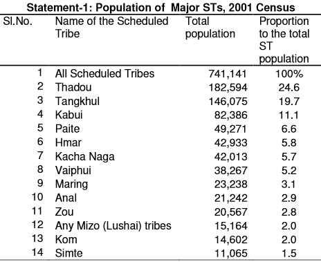
2. Of the total STs in Manipur, Thadou is the larg est with 1.8 lakh population representing 24.6 per cent of the state’s total ST population, followed by Tangkhul (19.7%), Kabui (11.1%), Paite (6.6%), Hmar (5.8%), Kacha Naga (5.7%), and Vaiphui (5.2%). Among other major tribes, Maring, A nal, Zou, Any Mizo (Lushai) tribes, Kom, and Simte are having percentages betwe en 3.1 and 1.5 (Statement-1). The rest of the STs are comparatively small in numb er having less then 10,000 population each.
3. The ST population in Manipur is predominantly r ural with 95.3 per cent rural and 4.7 per cent urban population. Of the thirteen major STs, Kacha Naga (99%), Anal (98.5%), Maring (98.2%), and Simte (98.1%) hav e returned majority (98-99%) of their population in rural areas.
4. The highest concentration of urban population a t 14.5 per cent has been recorded among Any Mizo (Lushai) tribes, followed b y Kabui (11.3%) and it is less than 5 per cent among rest of the thirteen main STs in the state.
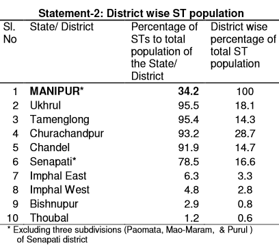
5. The Ukhrul, Tamenglong, Churachandpur, and Chan del are predominantly tribal districts having more than 90 per cent of th e district’s population as ST. The Senapati has recorded 78.5 per cent of its populati on as ST. These five districts together hold 92.4 per cent of the state’s total ST population. The rest of the four districts of Manipur have negligible percentage of ST population, Statement-2.
Sex Ratio
6. As per 2001 Census, sex ratio of the ST popula tion is 980, which is higher than the national average for STs (978). The state, however, has recorded low child sex ratio (0-6 age group) of 959 as compared to the national average (973).
7. Of the thirteen main STs, Anal has recorded pre ponderance of females over males with the highest sex ratio of 1031. Simte has recorded a balanced sex ratio (1000). The sex ratio is, however, comparatively l ow among Maring (954), Kacha Naga (961), and Tangkhul (965).
8. The Simte (1039) and Vaiphui (1001) have recor ded more girls per thousand boys in the age group 0-6. The Kabui (930) , Hmar (932), Kacha Naga (936), Tangkhul (941), and Zau (944) have recorded child sex ratio below the state average for STs. Kom has recorded the lowest child sex ratio at 903.
Literacy & Educational Level
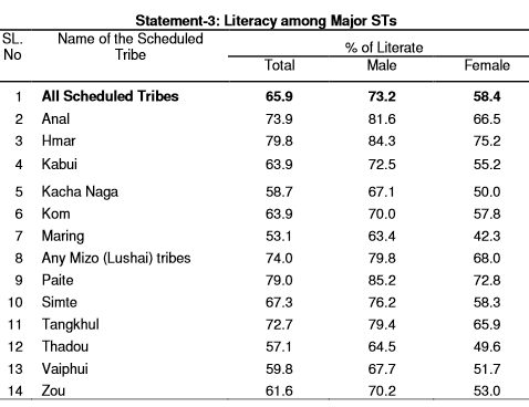
9. The Scheduled Tribe population in Manipur has recorded 65.9 per cent literacy, which is above the national average for S Ts (47.1%). The females are lagging behind by 14.7 per cent points in literacy rates than their male counterpart with male and female literacy at 73.2 per cent and 58.4 per cent respectively.
10. Of the thirteen major STs, Hmar has recorded the highest literacy of 79.8 per cent, followed by Paite (79%), Any Mizo (L ushai) tribes (74%), Anal (73.9%), and Tangkhul (72.7%). On the contrary lite racy rate is less than 50 per cent among Maring (53.1%), Thadou (57.1%), Kacha Naga (5 8.7%), and Vaiphui (59.8%), Statement-3.
11. The highest gender gap in literacy has been re corded among Maring. With 63.4 per cent male and 42.3 per cent female literac y, the Maring females are lagging behind by 21.1 percentage points. The gender gap is the lowest at 9.1 percentage points among Hmar.
12. In the age group 5-14 years, 69.2 per cent of the ST population is attending schools or any other educational institutions. Of t he thirteen major STs, Paite has recorded the highest 79.9 per cent, closely followe d by Tangkhul (77.9%), Hmar (73.9%), Anal (71.9%), and Kom (71.3%). Thadou (60 .5%) has the lowest percentage attending school in the age group 5-14 y ears.
13. Of the total ST literates 6.2 per cent are hav ing educational level graduation and above. The Tangkhul has recorded the highest at 8.2 per cent among the thirteen main STs in the state, closely followed by Any Mizo (Lushai) tribes (8%). It is, however, the lowest at 3.6 per cent among Kacha Naga.
Work Participation Rate (WPR)
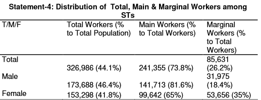
14. In 2001 Census, 44.1 per cent of the ST populat ion of the state has been recorded as workers, which is below the aggregated national figure for STs as a whole (49.1%). Of the total workers, 73.8 per cent have been recorded as main workers and 26.2 per cent as marginal workers. The female WPR (41.8 per cent) is lower than male WPR (46.4%). Among female workers 6 5 per cent have been recorded as main workers against 81.6 per cent amon g males.
15. Of the thirteen major STs, Maring has recorde d the highest WPR at 50.4 per. cent, while it is the lowest among Paite (37.5%).
16. It is significant that among Maring and Kacha Naga the female WPR is higher than that of their male counter parts. On the contr ary the gender gap in work participation is significant among Any Mizo (Lushai ) tribes (male 46.2%, female 35.8%), Paite (male 42.4%, female 32.6%) and Anal ( male 47.3%, female 38.5%).
Category of Workers
17. The STs in Manipur are predominantly cultivat ors as 69.7 per cent of the total ST main workers have been recorded as ‘cultivators’ and 4.4 per cent ‘agricultural labourer’.
18. Individual ST wise, among the thirteen major S Ts, Kacha Naga has recorded the highest 87.2 per cent of main workers as cultiv ators. It is more than 70 per cent among Simte (77.2%), Maring (75%), Hmar (74.3%), Th adou (73.6%), and Tangkhul (71.9%). On the other hand the Paite has recorded the lowest at 50.6 per cent as cultivators.
Marital Status
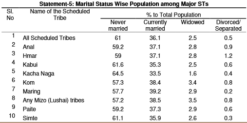
19. The distribution of ST population by marital status shows that 61 per cent is never married, 36.1 per cent currently married, 2.5 per cent widowed, and merely 0.5 per cent divorced /separated, Statement-5.
0. Merely 1.3 per cent of the ST female populati on below 18 years – the minimum legal age for marriage – has been recorded as ever married. The ever married males below 21 years constitute only 1.2 pe r cent of the total ST population Of the thirteen major STs, Kabui has recorded the h ighest percentage of ever married female (1.7%) and male (1.6%) below the leg al age at the 2001 Census.
Religion
21. The ST population in Mizoram is predominantly Christian. As per 2001 Census, of the total 741,141 ST population 717,604 are Christians constituting 96.8 per cent. ‘Other religions and persuasions’ account for 1.6 per cent and just one per cent are Hindus.
See also
The mayaang editors of Indpaedia have archived such a large number of articles about Manipur--mostly thanks to the excellent research encouraged by The Sangai Express--that your free online archive is often viewed as a Manipurpaedia.
These articles cover the whole gamut
And in the alphabetical order:
Chaga Ngee (The Blessed Festival) <>
Hunphun Luira Festival: Manipur <>
Imphal, 1908 <>
Imphal: Eema Keithel, Khwairamband Bazaar <>
Kangla <>
Manipur Merger Agreement, 1949 <>
Manipur: 1890-1930 (History) <>
Manipur: Imphal City & Surrounding Areas <>
Manipur: Parliamentary elections <>
Manipur: Polo (Sagol Kangjei) <>
Miss Manipur <>
Mohen Naorem <>
Romi Meetei <>
Samurailatpam Sanahanbi Devi: Manipur <>
Tingkao Ragwang Chapriak religion <>
Zeliangrong: Birth and puberty ceremonies <>
Zeliangrong: Namsu Namdimmei and Khangchiu <>
... and many more.
Try our Search box on the top left of this page.
You can update or correct these pages, and/ or send photographs and articles on these or new topics to the Facebook page, Indpaedia.com. All information used will be duly acknowledged.

