Baroda Prant
This article has been extracted from THE IMPERIAL GAZETTEER OF INDIA , 1908. OXFORD, AT THE CLARENDON PRESS. |
Note: National, provincial and district boundaries have changed considerably since 1908. Typically, old states, ‘divisions’ and districts have been broken into smaller units, units, and many tahsils upgraded to districts.Many units have since been renamed. Therefore, this article is being posted mainly for its historical value.
Baroda Prant
A prant or district of the Baroda State, lying between 21° 50' and 22° 45' N. and 72° 35' and 73° 50' E., with an area of 1,887 square miles. It is bounded on the north by the Kaira District of Bombay ; on the west by Broach, Cambay, and part of Kaira ; on the south by Broach and the Rewa Kantha ; and on the east by the Rewa Kantha and the Panch Mahals. Most of the prant forms a compact block between the Narbada and the Mahl, but the Petlad taluka lies separate, north of the latter river. The southern portion of the prant is largely composed of black soil, which, though fertile, produces few trees. In the north the red soil is thickly wooded. The prant is either traversed or skirted by the rivers Mahi, Dhadhar, Narbada, Vishwamitri, Surya, Meni, Or, Hiran, Unchh, and Oswan.
The country is largely under cultivation, and the vegetation there- fore consists chiefly of the crops with their accompanying weeds. The hedges enclosing fields consist of shrubs like Maerua, Cadaba, Dios- Pyros, Celastrus, with occasionally fleshy species of Euphorbia ; asso- ciated with these shrubby species are trees of Bombax malabaricum. The climbing plants in the hedges include species of Leguminosae, Convolvulaceae, Menispermaceae, and Asdepiadaceae. In waste places and on waysides occur Tephrosia purpurea, Heylandia latebrosa, Waltheria indica, Hibiscus Gibsoni, Argemone mexicana, and similar species. In the neighbourhood of dwellings are seen mangoes, tamarinds, baels, several species of Ficus, Anona squamosa, Jatropha Curcas, and other more or less useful planted or sub-spontaneous species.
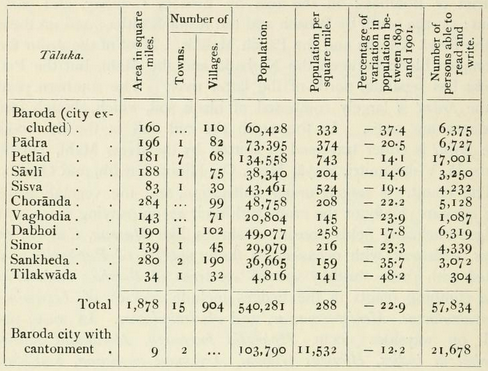
The population in 1872 was estimated at 747,437, and at the next two enumerations it was (1881) 761,501, (1891) 817,023; while in 1901 it was only 644,071, of whom 523,999 were Hindus, 36,713 Ani- mists, 64,148 Musalmans, and 10,916 Jains. The terrible diminution in the population was due to the disastrous effects of famine and plague. The prant is divided into nine talukas and two petas or sub- talukas, the population of which in 1901 is showai in the table on the next page.
The principal towns are Baroda City, Petlad, Dabhoi, Sojitra, Vaso, Padra, Nar, Pihij, and Sinor. Gujarati is spoken by 93 per cent, of the population, and Hindustani by 5 per cent., while nearly a fourth of the inhabitants of the city use Marathi. In 1901 the prant contained 6,943 native Christians. The American Methodist Episcopal Mission has adherents in 125 villages and towns, numbering approxi- mately 5,200. In addition to two orphanages, it provides a training school for teachers and preachers, and fifty-five day-schools.
The prevailing black soil is very fertile, and requires little manure or irrigation, while gorat or sandy loam needs both. The Petlad taluka is noted for the cultivation of tobacco. The chief crops are rice, bajra, jowar, wheat, math, gram, adad, tuver, val, chola, tal, diveli, cotton, sugar-cane, kasumbo, and tobacco. Many other minor crops and vegetable products are raised for local consumption.
The weaving of coarse cotton cloth is the chief industry. But in addition may be mentioned the manufacture of fine turbans at Dabhoi, of cloths at Sojitra, Petlad, and Bakrol, of embroidery with gold and silver thread at Baroda, and of gold and silver ornaments in most towns. Iron-work is poor, but good locks are made at Petlad, Sojitra, and Vaso. Excellent brass and copper pots are manufactured every- where. The only cotton-mill is at Baroda, but there are twenty-six ginning factories. A dyeing factory has been working at Petlad for some years. The chief centres of trade are Baroda, Dabhoi, Chandod, and Petlad, which are connected by rail. The prant is well provided with communications, as the main line of the Bombay, Baroda, and Central India Railway runs from north to south, with a State branch from Anand to Petlad and Cambay, and narrow-gauge lines connect Dabhoi with Bodeli, Chandod, Sinor, and Mobha. In addition, the Baroda- Godhra chord line on the broad gauge crosses the prant. The chief roads are those from Baroda to Padra, Makarpura, Ajwa, and Savli, from Petlad to Sojitra, and from Chandod to Sinor.
The land revenue decreased from 37.9 lakhs in 1881 to 36.8 in 1891, but rose to 39.8 lakhs in 1901. In 1904-5 the demand was 30-7 lakhs, but owing to famine only 23-8 lakhs was collected. The average assessment per bigha (4/7 acre) varies from about R. 0-3-9 in Padra to Rs. 4 in Sinor. The prant was settled for fifteen years between 1888 and 1893, and a revision is now in progress. Besides Baroda city in the prant contains ten municipalities: namely, Dabhoi, Petlad, Padra, Sinor, Sojitra, Vaso, Savli, Bhadran, Sankheda, and Makarpura. Their funds, amounting to Rs. 14,800 in 1904-5, besides the income from customs, excise, and tolls in Dabhoi, are provided by the State. A District board and local boards were con- stituted in 1905.
The prant is administered by the Subah, whose head-quarters are at Baroda city. The prant Judge also holds his court at the same place.
Education is well provided for, there being a college in Baroda city and also a high school, while the number of Anglo-vernacular schools is 6, and of vernacular schools 476. These schools were attended in 1904-5 by 35,780 pupils. The. prant contains a civil hospital, a leper hospital, a lunatic asylum, and 10 dispensaries, in which 131,322 patients were relieved in 1904-5, of whom 1,044 were in-patients.
