Bareilly Division
This article has been extracted from THE IMPERIAL GAZETTEER OF INDIA , 1908. OXFORD, AT THE CLARENDON PRESS. |
Note: National, provincial and district boundaries have changed considerably since 1908. Typically, old states, ‘divisions’ and districts have been broken into smaller units, units, and many tahsils upgraded to districts.Many units have since been renamed. Therefore, this article is being posted mainly for its historical value.
Bareilly Division
North-central Division of the United Provinces, lying below the Himalayas between 27° 35' and 29° 58' N. and 78° and 80° 27' E. It is bounded on the north by the sub-Himalayan tract of the Kumaun Division and by Nepal ; on the west and south by the Ganges, which divides it from the Meerut and Agra Divisions ; and on the east by the Lucknow Division of Oudh.
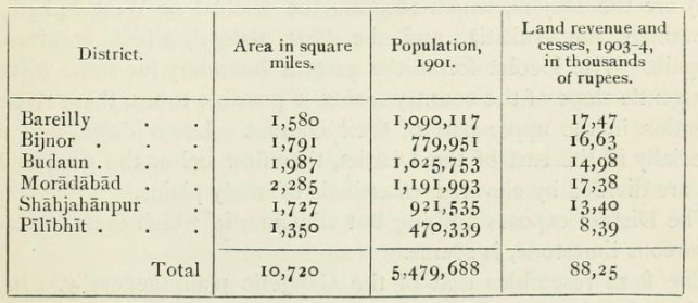
The Rampur State forms a wedge of territory between the Districts of Moradabad and Bareilly, and political control is exercised by the Commissioner of this Division, whose head-quarters are at Bareilly city. Population decreased between 1872 and 1881, but has increased considerably since. The numbers at the last four enumerations were as follows : (1872) 5,252,325, (1881) 5,122,557, (1891) 5,344,054, and (1901) 5,479,688. The total area is 10,720 square miles, and the density of population 511 persons per square mile, compared with 445 for the Provinces as a whole. The Division is the sixth largest in area and the sixth in population in the United Provinces. In 1901 Hindus formed nearly 75 per cent, of the total, and Musalmans 24 per cent., while the other religions most largely represented were Christians (24,459, of whom 21,421 were natives), Aryas (14,993), Sikhs (3,334), and Jains (2,016). The Division includes six Districts, as shown below
The northern portions of each of these Districts, except Budaun,
reach to the damp submontane area called the tarai, and the Division
generally is a fertile tract, especially noted for the production of sugar-
cane. There are 65 towns and 11,403 villages. The largest towns are
Bareilly (131,208, with cantonments), Shahjahanpur (76,458, with
cantonments), Moradabad (75,128), Amroha (40,077), Sambhal
(39,715), Budaun (39,031), Pilibhit (33,490). Chandausi (25,711),
and Nagina (21,412). The chief places of commercial importance are
Bareilly, Shahjahanpur, Moradabad, Pilibhit, Chandausi, and Tilhar.
Sugar and grain are dealt with also in many smaller places. Although
ancient sites occur in many parts of the Division, Ramnagar is the
only one which has been even partially explored. Budaun and
Sambhal were early seats of Muhammadan governors; and Bareilly,
Pilibhit, Rampur, and Aonla were important centres during the
Rohilla rule in the eighteenth century. See Rohilkhand.
