Aravali range
(→Haryana’s point of view/ 2017) |
(→2019: Haryana removes legal cover from 30,000ha of foothill land) |
||
| (6 intermediate revisions by 2 users not shown) | |||
| Line 297: | Line 297: | ||
Black day for environment, say activists & Oppn. Govt calls it a much-needed move | Black day for environment, say activists & Oppn. Govt calls it a much-needed move | ||
| − | =Damage= | + | ==22,425 hectares in NCR get ‘protected forest’ tag/ 2024== |
| + | [https://epaper.indiatimes.com/article-share?article=04_03_2024_007_006_cap_TOI Ipsita Pati, March 4, 2024: ''The Times of India''] | ||
| + | |||
| + | Gurgaon : Around 85% of the Aravali land, which was to be included in the compensatory afforestation plan, has finally got legal cover as ‘protected forest’. A total of 22,425ha of land spread across five districts of Haryana have been notified now. | ||
| + | |||
| + |
The gain for the Aravalis, which have degraded over the years due to mining and construction, comes at the cost of tropical rainforests in Great Nicobar. In Nov 2022, the ministry of environment, forest and climate change (MoEFCC) had cleared the decks for a mega project to build an international airport, a shipment port, a power plant and a township over 160sq km of land, over 80% of which are forests on the island. Compensatory afforestation to make up for this loss of forest in Nicobar was decided to be carried out in the Aravalis, some 2,400km apart. The process to identify Aravali land for compensatory afforestation began in Feb 2023. | ||
| + | |||
| + |
The five districts, which have been included in the plan, are Gurgaon, Nuh, Rewari, Mahendergarh and Charkhi Dadri. Till now, 22,425ha have been notified as ‘protected forest’ and 1,928ha will get the tag soon.
| ||
| + | |||
| + | In Gurgaon, 1,194ha have been notified. A total of 11,118ha got the protected tag in Nuh, followed by Rewari (3,582ha) and Mahendergarh (6,530ha). An additional 1,306 ha in Gurgaon, 24ha in Mahendergarh and 596ha in Charkhi Dadri will get the tag soon.
| ||
| + | |||
| + | Any non-forest activity such as construction, cattle grazing and pasturing, fishing, hunting is barred in these areas. Exceptions are only allowed if the forest department gives its permission. | ||
| + | |||
| + |
“We will also notify the remaining 1,647ha of land to achieve the target. We are also in the process of finalising the proposal for restoration and compensatory afforestation action plan. This will be submitted to the forest ministry for final nod,” said a forest official. | ||
| + | |||
| + |
The notification will be a fillip to Haryana’s recorded forest area. According to a Forest Survey of India (FSI) assessment in 2021, the state has 34,500ha of recorded forest cover, but another 1.3 lakh ha are not officially tagged, keeping them out of the purview of any protection. | ||
| + | |||
| + |
The state is fast losing forest cover. The same report by FSI had noted that Gurgaon alone lost 247 ha of forest cover between 2019 and 2020. | ||
| + | |||
| + |
In Gurgaon, the notified Aravali forest areas under the swap are spread across six villages — Ghamroj, Alipur, Tikli, Sakatpur, Gairatpur Bas and Aklimpur. Another 34 villages in Rewari, 68 villages in Nuh and 53 villages in Mahendergarh have also got protected land. Earlier, these areas were owned by village panchayats, and thus the forest department was unable to protect them from getting encroached. | ||
| + | |||
| + |
Meanwhile, activists questioned how compensatory afforestation in Haryana would help reduce the environmental impact of the loss of greenery in Nicobar. “Why has govt not included Faridabad’s forest areas in the notified land? Several real estate firms have bought land in the Faridabad Aravalis. Why is govt not trying to save those areas?” asked Vivek Kamboj, an environmentalist.
| ||
| + | |||
| + | Responding to this, a forest official said they didn’t include the Faridabad Aravalis as there wasn’t a suitable continuous tract of forest land for afforestation. | ||
| + | |||
| + | [[Category:Fauna|AARAVALI RANGEARAVALI RANGE | ||
| + | ARAVALI RANGE]] | ||
| + | [[Category:India|AARAVALI RANGEARAVALI RANGE | ||
| + | ARAVALI RANGE]] | ||
| + | [[Category:Name|ALPHABETARAVALI RANGEARAVALI RANGE | ||
| + | ARAVALI RANGE]] | ||
| + | [[Category:Pages with broken file links|ARAVALI RANGEARAVALI RANGEARAVALI RANGEARAVALI RANGE | ||
| + | ARAVALI RANGE]] | ||
| + | [[Category:Places|AARAVALI RANGEARAVALI RANGE | ||
| + | ARAVALI RANGE]] | ||
| + | |||
| + | =Court judgements= | ||
| + | ==NGT: 2013-22== | ||
| + | [https://epaper.timesgroup.com/article-share?article=13_12_2022_005_004_cap_TOI Ipsita Pati, Dec 13, 2022: ''The Times of India''] | ||
| + | |||
| + | [[File: The Aravalis, Rulings of the NGT- 2013-22.jpg|The Aravalis/ Rulings of the NGT- 2013-22 <br/> From: [https://epaper.timesgroup.com/article-share?article=13_12_2022_005_004_cap_TOI Ipsita Pati, Dec 13, 2022: ''The Times of India'']|frame|500px]] | ||
| + | |||
| + | Gurgaon : A landmark journey at the National Green Tribunal (NGT) that began nine years ago with a TOI report, morphed into a petition, and led to several significant measures to protect forest areas in Aravalis, including Mangar, drew to a close this month. It left the vulnerable hill ranges significantly better fortified against any onslaught of illegal construction. | ||
| + | |||
| + |
Wrapping up proceedings on December 9 in a case that came to be called Sonya Ghosh vs State of Haryana, the NGT directed the Haryana and Rajasthan governments to set up a monitoring committee and conduct periodic reviews till all encroaching construction is removed from protected Aravali land in three Haryana districts – Gurgaon, Faridabad and Nuh – and Alwar in Rajasthan on land classified as ‘gair mumkin pahar (uncultivable hill)’.
| ||
| + | |||
| + | The tribunal also askedthe chief secretaries of both states to ensure compliance with the directions. | ||
| + | |||
| + |
Among the most significant outcomes of the NGT proceedings was the deletion of the term ‘gair mumkin farmhouse’ from revenue records by the Gurgaon administration in 2020 and their replacement with ‘gair mumkin pahar’ (uncultivable hill). The term, which found its way insidiously into the records, allowed farmhouse owners to circumvent provisions of the Aravali Notification 1992 that recognises ‘gair mumkin pahar’ as protected land. | ||
| + | |||
| + |
The NGT admitted Sonya Ghosh’s petition on December 12, 2013. But the start of proceedings predated the petition. On January 7 that year, the tribunal took cognisance of a TOI report on illegal construction on forest land in the Aravalis, titled ‘How private players grabbed forest land in the Aravalis’, and sought a response from the Haryana government. | ||
| + | |||
| + |
The court followed that up by ordering a stop to non-for-est activity and a survey of forest land in three affectedvillages – Kot and Mangar in Faridabad and Roz Ka Gujjarin Gurgaon – before admitting an impleadment applica-tion by Ghosh that winter, Aagney Sail, the petitioner’s counsel, told TOI. | ||
| + | |||
| + |
The first judgment in the case came in 2018, when the NGT declared that any construction on land covered by the Aravali Notification is illegal and directed the Haryana government to restore the forest in encroached areas like Raisina Hill in Gurgaon. “Construction on forest land or areas covered by Aravali Notification is illegal, and such forest land has to be restored… any construction raised on the forest area or the area otherwise covered by (Aravali )notification without permission of the competent authority (after the date of the notification) has to be treated as illegal and such forest land has to be restored,” the NGT stated in its ruling. | ||
| + | |||
| + |
The NGT gave the Haryana government two months to set up a committee and three months to identify all forest land covered by the Aravali Notification. The committee was,however, formed only in July 2019. | ||
| + | |||
| + | Demolition notices were issued to farmhouses, but in most cases, this wasn’t followed up by an actual demolition.
The deletion of the term ‘gair mumkin farmhouse’ in May 2020 removed the shield farmhouses had despite being illegally built. | ||
| + | Though the terminology had no impact on the ownership, it did away with equivocation that ‘gair mumkin farmhouse’ created and brought the land in question under the clauses of the Aravali Notification to disallow any ‘non-forest’ activity. | ||
| + |
Demolitions in Raisina in compliance with the NGT order have only recently begun.
Disposing of the petition on December 9, an NGT bench of chairman Adarsh Kumar Goel, judicial member Sudhir Agarwal and expert members A Senthil Vel and Afroz Ahmad asked the Haryana and Rajasthan government to continue with remedial action in accordance with the law. “Having monitored the mat-ter for almost 1o years, the encroachers having been identified and the states of Rajasthan and Haryana having constituted their monitoring mechanism, it will be appropriate to direct that further remedial action may be taken by the states of Rajasthan and Haryana in accordance with law,” stated the judgment. | ||
| + | |||
| + |
The tribunal noted that government departments had worked to remove encroachments in their jurisdiction and submitted actiontaken reports. Over the nearly 10 years, there were 71 hearings of the case in the NGT. | ||
| + | |||
| + |
According to a forest department survey, at least 500 farmhouses have been built illegally on Aravali land in Gurgaon, concentrated in areas like Gwalpahari, Abheypur, Gairatpur Bas, Sohna, Raisina and Manesar. A detailed list of these constructions was submitted to the NGT in the Sonya Ghosh case last year. The report also had details of the total area occupied by them and their locations. | ||
| + | |||
| + | [[Category:Fauna|AARAVALI RANGEARAVALI RANGE | ||
| + | ARAVALI RANGE]] | ||
| + | [[Category:India|AARAVALI RANGEARAVALI RANGE | ||
| + | ARAVALI RANGE]] | ||
| + | [[Category:Name|ALPHABETARAVALI RANGEARAVALI RANGE | ||
| + | ARAVALI RANGE]] | ||
| + | [[Category:Pages with broken file links|ARAVALI RANGE | ||
| + | ARAVALI RANGE]] | ||
| + | [[Category:Places|AARAVALI RANGEARAVALI RANGE | ||
| + | ARAVALI RANGE]] | ||
| + | |||
| + | =Damage, the extent of= | ||
==‘Damage to Aravallis scary’: SC== | ==‘Damage to Aravallis scary’: SC== | ||
[https://www.thehindu.com/news/national/damage-to-aravallis-scary/article24929009.ece Krishnadas Rajagopal, SC orders demolition of illegal structures, September 11, 2018: ''The Hindu''] | [https://www.thehindu.com/news/national/damage-to-aravallis-scary/article24929009.ece Krishnadas Rajagopal, SC orders demolition of illegal structures, September 11, 2018: ''The Hindu''] | ||
| Line 359: | Line 436: | ||
In its report, CEC said illegal mining was going on in 15 districts in Rajastan and districts of Alwar, Dungarpur and Sikar were worst affected. It said illegal mining was going on over an area of 115.34 hectares. It said the majority of mining leases in the state had been granted in “clusters”. The court posted the case for October 29 to examine compliance of its orders. | In its report, CEC said illegal mining was going on in 15 districts in Rajastan and districts of Alwar, Dungarpur and Sikar were worst affected. It said illegal mining was going on over an area of 115.34 hectares. It said the majority of mining leases in the state had been granted in “clusters”. The court posted the case for October 29 to examine compliance of its orders. | ||
| + | |||
| + | ==Hundreds of hillocks flattened, sandstorms reach NCR/ 2023== | ||
| + | [https://timesofindia.indiatimes.com/india/hundreds-of-aravali-hillocks-flattened-sandstorms-reaching-ncr-study/articleshow/100751783.cms Shoeb Khan, June 5, 2023: ''The Times of India''] | ||
| + | |||
| + | |||
| + | JAIPUR: Scores of Aravali hills have vanished in the past 20 years due to unchecked mining and urbanisation, threatening the flora and fauna of one of the world’s oldest mountain ranges and leaving the path open for sandstorms from the Thar desert to hit the national capital region (NCR) and western UP and increased conflicts with animals, warns an ongoing study on the state of the hill range. The findings have come in a research of the Central University of Rajasthan (CURaj), which has identified over 31 hills in the upper Aravali range that have disappeared in the last two decades, besides “hundreds of hills” in the lower and middle levels. | ||
| + | |||
| + | “The systematic disappearance of hills at the upper level was recorded in Naraina, Kalwar, Kotputli, Jhalana and Sariska with heights of 200 metres to 600 metres above sea level. However, the count of vanishing hills at the lower and middle level, with heights between 50 to 200 metres above sea level, has yet to be completed. All I can share now are the preliminary results which are very alarming,” said L K Sharma, head of department of environmental science, CURaj. | ||
| + | |||
| + | The denudation has led to man-animal conflicts as leopards, chinkara and sambhar deer, which find home in the hills, enter human settlements. Rare plants like neel, chonakurinji and karun kurinji also face wipe-out threats. | ||
| + | |||
| + | [[Category:Fauna|AARAVALI RANGEARAVALI RANGE | ||
| + | ARAVALI RANGE]] | ||
| + | [[Category:India|AARAVALI RANGEARAVALI RANGE | ||
| + | ARAVALI RANGE]] | ||
| + | [[Category:Name|ALPHABETARAVALI RANGEARAVALI RANGE | ||
| + | ARAVALI RANGE]] | ||
| + | [[Category:Pages with broken file links|ARAVALI RANGEARAVALI RANGEARAVALI RANGEARAVALI RANGE | ||
| + | ARAVALI RANGE]] | ||
| + | [[Category:Places|AARAVALI RANGEARAVALI RANGE | ||
| + | ARAVALI RANGE]] | ||
| + | |||
| + | ==1975 – 2019== | ||
| + | [https://epaper.timesgroup.com/article-share?article=18_06_2023_001_021_cap_TOI Ipsita Pati, June 18, 2023: ''The Times of India''] | ||
| + | |||
| + | Gurgaon : Between 1975 and 2019, nearly 8% of the Aravali hills have disappeared, says a study of the ranges across four states, projecting the losses to rise to around 22% by 2059 if “explosive” urbanisation and mining continue at the current pace, reports Ipsita Pati. | ||
| + | |||
| + |
Delhi-NCR, according to the researchers, will be at the heart of both the cause and effect of this loss. The Aravalis, the study infers, are most vulnerable here, and as more hills get flattened, they will open a “gateway” for the Thar desert to expand towards the national capital area,which implies a more dusty and arid landscape, a rise in pollution levels and more erratic weather patterns. | ||
| + | |||
| + | ===Details=== | ||
| + | [https://epaper.timesgroup.com/article-share?article=18_06_2023_008_006_cap_TOI Ipsita Pati, June 18, 2023: ''The Times of India''] | ||
| + | |||
| + | [[File: Impact of mining on Aravali.jpg|Impact of mining on Aravali <br/> From: [https://epaper.timesgroup.com/article-share?article=18_06_2023_008_006_cap_TOI Ipsita Pati, June 18, 2023: ''The Times of India'']|frame|500px]] | ||
| + | |||
| + | Gurgaon : Nearly 8% of the Aravali hills have disappeared between 1975 and 2019, says a study of the ranges across four states. Researchers from the Central University of Rajasthan (CURaj) studied satellite images and landuse maps between 1975 and 2019 to come up with estimates. Their paper — titled Assessment of Land-Use Dynamics of the Aravalli Range — was published in the journal Science Earth Informatics this January. | ||
| + | |||
| + |
Data analysed by researchers showed that 5772. 7 sqkm (7. 6%) of the Aravali ranges was flattened in the 44-year period they studied. Of this, nearly 5% (3,676 sqkm) of the hills was converted into barren land and another 776. 8 sqkm (around 1%) into settlements. The projected loss by 2059 of total Aravali area is 16,360 sqkm, according to the report. | ||
| + | |||
| + |
In this time period, the average deforestation rate was 0. 57% annually, the study’s lead researcher Laxmi Kant Sharma told TOI. If this continues, the landscape in swathes of north India will become arid and desertification will set in, according to the study. | ||
| + | |||
| + |
“…change from 1975 to 2019, which shows that the Aravali range is passing through significant deterioration, where biodiversity loss is prominent… These deteriorated hill gaps have opened a gateway for desertification in the northeast part of Rajasthan to Delhi,” the study says. | ||
| + | |||
| + |
A total of 2,269 hills make up the Aravalis that extend from Gujarat to Delhi, via Rajasthan and Haryana. The hills and the forests of the ranges are natural barriers to the expansion of the Thar desert. Unchecked mining for stones and sand has been accelerating the rate of damage to the Aravalis over the decades. In October 2018, a central empowered committee appointed by the Supreme Court informed a bench of Justices Madan B Lokur and Deepak Gupta that one-fourth of the Aravali ranges in Rajasthan (31 out of 128 hills in the state) had disappeared over a 50-year period because of illegal mining. | ||
| + | |||
| + |
In adjacent south Haryana,despite the Supreme Court banning mining in Gurgaon, Faridabad and Nuh in 2009, it continues to make gashes in the ranges, operating through an entrenched network. | ||
| + | |||
| + | Last July, a Haryana Police DSP was crushed to death by the driver of a truck carrying illegally mined stones in Nuh. Earlier this week, a government team was attacked by 10-12 stick-wielding men at Sancholi village in Sohna. | ||
| + |
The CURaj study says 1,852 sqkm of the Aravalis is currently being mined in nine areas – Gurgaon, Faridabad, Rewari, Jaipur, Alwar and Ajmer. There are 4,150 mining leases, of which just 288 have environmental clearance, the study notes, citing data released by the Comptroller and Auditor General of India (CAG) in a report in 2017. | ||
| + |
Sharma, who is also the head of department of environmental science at CURaj, said that by the estimates of the study, 3. 5% (2,628. 6 sqkm) of the total Aravali area will be used for mining by 2059. | ||
| + | |||
| + | [[Category:Fauna|AARAVALI RANGEARAVALI RANGE | ||
| + | ARAVALI RANGE]] | ||
| + | [[Category:India|AARAVALI RANGEARAVALI RANGE | ||
| + | ARAVALI RANGE]] | ||
| + | [[Category:Name|ALPHABETARAVALI RANGEARAVALI RANGE | ||
| + | ARAVALI RANGE]] | ||
| + | [[Category:Pages with broken file links|ARAVALI RANGEARAVALI RANGEARAVALI RANGEARAVALI RANGE | ||
| + | ARAVALI RANGE]] | ||
| + | [[Category:Places|AARAVALI RANGEARAVALI RANGE | ||
| + | ARAVALI RANGE]] | ||
=Desertification= | =Desertification= | ||
| Line 472: | Line 609: | ||
Sources said that the revenue department wants to ensure that the drains and streams, which carry rainwater to the lake, are not blocked. ‘‘We have included this in the consolidation scheme so that the natural water supply to the lake is not disturbed. Though consolidation would be finalised soon, land owners would have to get approval for anything they do on their land,’’ said a senior revenue department official. | Sources said that the revenue department wants to ensure that the drains and streams, which carry rainwater to the lake, are not blocked. ‘‘We have included this in the consolidation scheme so that the natural water supply to the lake is not disturbed. Though consolidation would be finalised soon, land owners would have to get approval for anything they do on their land,’’ said a senior revenue department official. | ||
| + | |||
| + | |||
| + | |||
| + | |||
| + | [[Category:Fauna|AARAVALI RANGEARAVALI RANGE | ||
| + | ARAVALI RANGE]] | ||
| + | [[Category:India|AARAVALI RANGEARAVALI RANGE | ||
| + | ARAVALI RANGE]] | ||
| + | [[Category:Name|ALPHABETARAVALI RANGEARAVALI RANGE | ||
| + | ARAVALI RANGE]] | ||
| + | [[Category:Pages with broken file links|ARAVALI RANGEARAVALI RANGEARAVALI RANGE | ||
| + | ARAVALI RANGE]] | ||
| + | [[Category:Places|AARAVALI RANGEARAVALI RANGE | ||
| + | ARAVALI RANGE]] | ||
=Wildlife= | =Wildlife= | ||
Latest revision as of 21:03, 5 March 2024
This is a collection of articles archived for the excellence of their content. Readers will be able to edit existing articles and post new articles directly |
[edit] What are the Aravalis?
[edit] The 1992 definition
See graphics:
What are Aravalis-I
What are the Aravalis- II
Master Plan 2021 Defines Conservation Zones, Removes Ambiguity In Definition & Scope
The definition of Aravalis, whose definition of Aravalis, whose ambiguous interpretation has for years led to many court battles for the protection of the ecologically fragile hill ranges, has been decided by the Centre.
Removing all grey areas, which have been consistently exploited to give Aravali land away to real estate, particularly in Haryana, the Union environment ministry (MoEFCC) has told the National Green Tribunal that the Aravalis across NCR can be defined through their May 1992 notification.
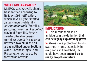
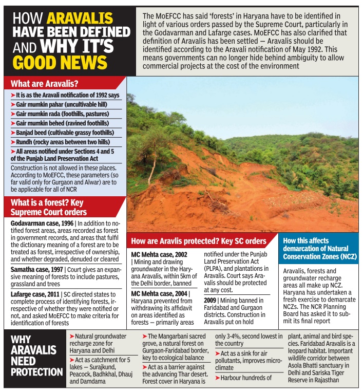
Known as the `Aravali notification', it says apart from reserved forests or places already classified as `forest' in government records, areas categorised as gair mumkin pahar (uncultivable hill), gair mumkin rada (foothills, pastures), gair mumkin be hed (ravined foothills), banjar beed (cultivable grassy foothills) and rundh (rocky areas between two hills) will be treated as Aravalis.
The same status is also to be given now to any land classified under sections 4 and 5 of the Punjab Land Preservation Act. All such areas in NCR will be protected and identified as Aravalis, the MoEFCC has told the green court.
The immediate implication of this is that it extends a protective cover to large swathes of land in NCR, especially in Gurgaon and Faridabad, and will strengthen the case of environmentalists fighting court battles. The submission by the Union environment ministry (MoEFCC) -made during a hearing into a recent tree-felling case in Faridabad where Aravali land was allotted to a real estate company -is also significant because the Haryana government has been claiming the status of such land has not yet been decided, leaving them open to real estate projects. Before this, the Aravali notification was applicable only to Gurgaon and Alwar (Rajasthan).
The affidavit in NGT also removes ambiguity around natural conservation zones (NCZ) -the other major area of environmental concern in NCR -stating NCZs have been clearly defined in the Regional Plan 2021 of the National Capital Region Planning Board (NCRPB). The affidavit states: “components of NCZ, including `forest,' `Aravali' and `groundwater recharging areas' are to be governed by various statutes, rules and notifications of the MoEFCC, other central government departments or ministries, orders of SC (Supreme Court) and high courts and MoEFCC's notification dated May 7, 1992“.
“Therefore, the issue related to definition has been adequately addressed. The NCR state governments have to accordingly delineate the NCZ...“ the affidavit states.Since NCZs incorporate the Aravalis, it would mean states such as Haryana have to define the Aravalis as well.
Another grey area in Haryana is the definition of `forest', which too has been exploited, and the MoEFCC affidavit throws light on that as well. It says `forest' in Haryana will have to be identified by the state in accordance with the Supreme Court judgment dated December 12, 1996 in the TN Godavarman case and that the exercise of identifying forests and preparation of geo-referenced maps has to be done by in line with the Supreme Court judgment of July 6, 2011in the Lafarge Uranium Mining Ltd case.
The Aravali hills of Haryana in Faridabad, Gurgaon and other districts are covered with forests that var y from pristine, like Mangarbani, to degraded scrub. Environmental analyst Chetan Agarwal explained, “The Godavarman judgment broadly said all forests would receive the protection of the Forest Conservation Act, irrespective of ownership, and classi fication, and their condition.The implication of this judgment is that for the purpose of the Forest Conservation Act of 1980, `forests' would include all statutory recognised forests, whether designated as reserved, protected or otherwise, those marked so in revenue records, and all areas, recorded or not, which fulfil the dictionary meaning of a `forest'. Therefore, virtually the entire Haryana Aravalis fulfil the dictionary meaning of `forest'.“
The MoEFCC said the decisions on the definition and demarcation of Aravalis were taken in a meeting of the NCR Planning Board headed by former urban development minister Venkaiah Naidu last December.In a separate affidavit to the NGT, the NCR Planning Board said the Haryana government is required to ascertain the status of NCZs. The Haryana government, which has over the years made several attempts to dilute the definition of NCZs, has started an exercise to redraw these natural conservation zones but hasn't completed it. “The Haryana government has to submit the final report along with maps on the NCZ delineation exercise,“ says the NCR Planning Board's affidavit.
The background to this case is that a real estate company had approached the Faridabad divisional forest officer, seeking permission to fell trees on a 52-acre plot it had acquired for a group housing society project in Sarai Khwaja, a village in Faridabad. Sarai Khwaja is recorded as gair mumkin pahar, which is protected under the Aravali notification. Between September and November 2015, the Faridabad forest officials had rejected approval for felling these trees because gair mumkin pahar's conservation status was “yet to be decided“.Thereafter, ignoring the opinion of the forest department, which had denied permission for tree-felling, Haryana's additional chief secretary issued a letter on April 24, 2017, directing the department to grant the developer approval for felling trees.
A senior forest official, who did not wish to be named, said NCZs should have been decided by the forest department but Haryana had given the job to the department of town and country planning, an agency that dealt with realtors. “The forest department has limited role in deciding NCZs,“ said the official.
[edit] Haryana’s point of view/ 2017
Jayashree Nandi, December 4, 2017: The Times of India
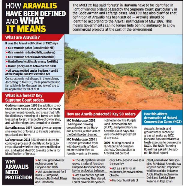
ii) Supreme Court orders, 1996;
iii) MC Mehta’s cases of 2002 and 2004;
iv) Why the Aravalis need protection
From: Jayashree Nandi, December 4, 2017: The Times of India
See graphic:
i) The 1992 definition of the Aravalis; ii) Supreme Court orders, 1996; iii) MC Mehta’s cases of 2002 and 2004; iv) Why the Aravalis need protection
The Haryana government is likely to submit its final view on what consists Aravalis in the state at the 37th meeting of the National Capital Region Planning Board (NCRPB) to be held on Monday. The agenda notes of the meeting accessed by TOI state that the Haryana government seeks to limit ‘Aravalis’ to only the stretches in Gurgaon. This leaves out large parts of the Aravalis in Faridabad (over 17,000 acres) and other districts from any kind of protective regulation.
The Haryana government has informed the NCRPB that it will consider only those areas to be part of the Aravali range that are mentioned in the Aravali notification of 1992 issued by the environment ministry and not recognise any additional areas to be Aravalis. The 1992 notification is applicable only to Gurgaon in Haryana and Alwar district in Rajasthan.
Why 17k acres of Aravali may be left out of protective cover
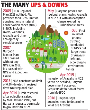
The agenda notes recount that the Haryana government is against any cap on construction activities in the natural conservation zones (NCZs) as defined in the draft regional plan 2021. The plan includes Aravalis in NCZs where construction is not allowed beyond 0.5% of the area. The Haryana government had, however, stated in the NCRPB’s special meeting in December 2016 that the 1992 notification allowed for construction of roads and buildings even in the Aravali areas with permission from the Union environment ministry. So, Haryana will not consider any additional cap on construction specified in the draft regional plan of NCRPB.
Further, in a letter dated June 15, 2017, the Haryana principal secretary (town and country planning department) has informed the ministry of urban development that it will consider only those areas to be Aravalis that are appended in the 1992 notification table. “Therefore, for any area of Haryana to be considered as being part of NCZ by virtue of being Aravalis, it must necessarily be a part of the said table,” the letter said.
The agenda notes said that NCRPB had written to the Haryana government to clarify their stand recently. “It appears that the above decision (limiting Aravalis to Gurgaon) has been taken without taking into consideration the decisions of the board taken in its special meeting held on December 20, 2016 w.r.t. identification or delineation of ‘Aravalli’. This is also against Govt of Haryana’s earlier confirmation in this regard given in the said Special Meeting of the Board. Accordingly, it is requested to reconsider the decision in the matter.”
In letters submitted to the National Green Tribunal (NGT) in July 2017, the Haryana government had claimed that “certain pockets recorded as gair mumkin pahar (uncultivable hill)” cannot be categorised as Aravalis as they are already being used for agriculture, roads, buildings and other such projects. A letter dated January 19, 2017, from Haryana CM Manohar Lal Khattar to Venkaiah Naidu, the then Union urban development minister, was also submitted in NGT along with an affidavit from the town and country planning department, which states that the Haryana government will enforce the ‘Aravali notification’ of 1992, which is only applicable to the Aravalis in Gurgaon and Alwar in Rajasthan.
But the Union environment ministry (MoEFCC) had told NGT that the Aravalis across NCR can be defined through the revenue record ‘terms’ listed in their May 1992 notification. Apart from reserved forests or places already classified as ‘forest’ in government records, areas categorised as gair mumkin pahar (uncultivable hill), gair mumkin rada (foothills, pastures), gair mumkin be hed (ravined foothills), banjar beed (cultivable grassy foothills) and rundh (rocky areas between two hills) in entire NCR will be treated as Aravalis.
The planning committee of NCRPB had also decided that the Aravalis in entire NCR be delineated based on the 1992 notification. “Therefore, Govt.of Haryana should expedite the exercise of NCZ delineation and submit the final report to the environment ministry, in compliance to the decision of the 35th board meeting,” the agenda notes state. But the Haryana government has still not started the process of delineation leaving ecologically sensitive areas vulnerable to real estate and other projects.
Earlier in May, 2015, the state had given an assurance in the board meeting of the NCRPB that it would maintain status quo on 50,000 acres of primarily Aravali areas, whose legal forest status was yet to be determined. However on May 12017, the government had withdrawn the forest status to be decided tag – stating there are no such areas in the state. This has left even the Mangar Bani sacred grove without a forest tag.
[edit] SC verdict: 2022
AmitAnand Choudhary, July 22, 2022: The Times of India
New Delhi: In a significant verdict for conservation of the Aravalis in Haryana, the Supreme Court ruled that land covered by special orders issued under Section 4 of the Punjab Land Preservation Act (PLPA), 1900, were forest land and these cannot be used for non-forest activities without prior approval of the Centre.
Haryana had argued that around 40% of the state, including entire Gurgaon and Faridabad districts, will come under “forests” if PLPA was strictly enforced. SC said the picture projected by the petitioners and state government was “completely misleading and fallacious”. It said only 7. 1% of total land in 22 districts was covered by special orders under the law. “We hold that the lands covered by special orders under Section 4 of PLPA have all the trappings of forest lands within the meaning of Section 2 of the Forest Act and, therefore, the state. . . cannot permit its use for non-forest activities without prior approval of the central government with effect from October 25,1980,” a bench of Justices A M Khanwilkar, Abhay S Oka and C T Ravikumar said.
[edit] Causes of damage
[edit] Mining
[edit] As in 2018
A drive down Gurugram-Alwar highway, with its scenic villages, green fields and rolling hills of the Aravali ranges, offers a pleasant break from the sparse, forbidding landscape of Delhi’s populous southern neighbour.
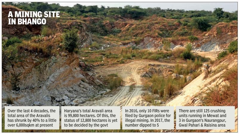
But the pleasantness is short-lived. As one gets closer to the hills, the scars begin to show, then the gashes. At Bhango, around 35km from Gurugram on the border with Rajasthan’s Alwar, entire hills have been defaced. Giant hollows have appeared on the rocky mass, altering the pyramidal shapes of several hills, an outcome of many decades of stone mining that has ground on despite bans, rules and court orders.
How mining is killing Aravalis hill by hill near Haryana-Raj border despite SC ban
These are the same ranges which, another few hours’ drive down the same road, have started disappearing in Rajasthan, where the axe of mining has fallen so regularly and brutally that entire hills have simply been wiped off the landscape. In their place have appeared dusty barren gaps that let the desert wind blow freely towards Delhi, compounding the capital’s problems with pollution.
Mining is banned in the Aravalis in Gurugram, Faridabad and Mewat (now Nuh) since 2002, through a Supreme Court order. But it never stopped in Bhango, which isn’t too far from the Nuh-Alwar border on the Haryana side. It was largely driven by the mining apparatus that operated in Rajasthan after the crackdown in Haryana in 2002.
The damage this has wrought to the ranges in Nuh is glaring. In place of rocky pathways that one expects to see between two hills is a wide dirt track with criss-crossing tyre marks of heavy trucks. These continue deep into the ranges, for around 3km, towards Tauru town. Just off the highway, cars cannot negotiate this terrain, but large trucks regularly do after dark, taking out tonnes of stones every week, say villagers.
A couple of giant craters — each 2-3 feet deep and 8 feet across — as “check posts”. “Cars or jeeps used by enforcement officials get stuck in these, so they don’t go any further,” says a local resident. The soil around the craters appeared to have been freshly dug, indicating they had been dug and enlarged to prevent officials from venturing ahead. “Illegal mining has been going on here. We keep hearing the dynamite blasts and movement of vehicles after sunset, once or twice every week. But we don’t venture out, fearing for our safety,” he added.
Years of abuse have created deep cavities in the terrain, up to 200-300m at certain stretches, which have turned into seasonal lakes. But even those will vanish in the coming years if illegal mining is not curbed completely. At the nearby Raisina hills in Chehalka and Rithoj villages, the damage to the ranges is similar. It gets worse in Rithath village, located along the Rajasthan border.
The Supreme Court’s central empowered committee said in its report last week that 31 of 128 hills in the Aravali region of Rajasthan were gone forever. How much longer before the same starts happening to the ranges in Haryana? At Bhango, Chehelka and Rithoj, villagers say the clock has anyway started ticking, and the landscape today has lost large portions of hills they had seen in their youths.
Activists have said banning illegal mining in Gurugram, Faridabad and Mewat won’t be sufficient if stone crushing units are allowed to continue in the vicinity. Miners don’t take stones quarried in Haryana across the border, but straight to local crushers, camouflaged under a thick layer of sand. There are 125 stone crushing units in Mewat and three in Gurugram’s Sohna subdivision. It is estimated that currently, 4-5 trucks carrying illegally mined stones arrive at these units every week.
“Two years ago, we wrote to the state government that we need to ban the crushing units along Pali on Gurugram-Faridabad road along with the mining ban. So long as these units exist, violators will have a readily available option to disguise their illegal activity. Our experience shows illegal stone mining could be curbed only in areas where crushers too were shut down,” said Jitender Bhadana, an environmentalist.
Illegal mining isn’t the only problem, though — stones from the Aravalis are in high demand locally to build houses and boundary walls. Sources said the Central Empowered Committee inspected the hills in south Haryana in July this year and listed stone quarrying by villagers for personal use as one of the factors behind the damage to the hills.
“While accompanying the CEC team, we noticed piles of stones outside homes, for use in construction. But officials dismissed it, saying it was for personal consumption and not for commercial use. But the fact remains the hills are being damaged and stones are being used,” said Ramesh Arya, who filed a writ petition in the Supreme Court against illegal mining in Haryana and Rajasthan.
Rajendra Prasad, mining officer for Gurugram and Mewat, admitted theft of stones in Mewat but said there was no illegal mining in the Gurgaon area. “Although there is some theft of stones in Mewat, even that is not illegal mining. Our survey shows there is a 3% theft of stones in Mewat in comparison to what it was till 2002. This theft is by residents who use the material for building houses there. We cannot completely curb this as local sourcing is difficult to stop,” he said.
[edit] Conservation mechanisms
[edit] 2016
[edit] Haryana, 2016: protection of "potential" wildlife areas
The Times of India, Feb 05 2016
Wildlife study to find focus spots
Jayashree Nandi
A study by the Wildlife Institute of India (WII) will soon point out “potential“ wildlife areas in the Aravalis in Haryana that require special conservation measures and protection from urbanisation. The Haryana forest department had commissioned WII to carry out a survey to identify vulnerable areas that needed government intervention.
The Aravali range ends in Haryana and is, therefore, an ecologically fragile region that is threatened by modernity . Unlike in Rajasthan, which has a number of protected areas, including the Sariska National Park, the wildlife-rich areas of Haryana had never been identified. “The forest department wants to have a document at hand to be able to resist any pressure to change land use,“ said Bilal Habib of the animal ecology and conservation biology department at WII.
The WII team comprising project biologists Anchal Bhasin and Paridhi Jain, along with local villagers, have finished scouting a 30-km area around Damdama lake, Sultanpur Bird Sanctuary and parts of Mewat in the past month or so.They found ample evidence of wildlife, particularly around Damdama lake, including a 2.5-km-long trail of leopard pugmarks. They also noticed hyena pugmarks and some unidentified pugmarks that could be of the Indian fox.
Despite the presence of tigers in the Rajasthan Aravalis, the WII team isn't quite hopeful of finding the big cats on the Haryana side because the habitat is quite degraded. “There is too much human presence and disturbance for tigers to be living here. Tigers also don't prefer undulating terrain as habitats,“ explained Bhasin.She said that if it could be confirmed that the Indian fox could indeed be found here, it would be an important discovery .Indicators of leopard presence are, of course, the most important discovery because it means there are many other smal ler animals living there on which the spotted cats prey .
[edit] Natural Conservation Zone
The Times of India, April 7, 2016
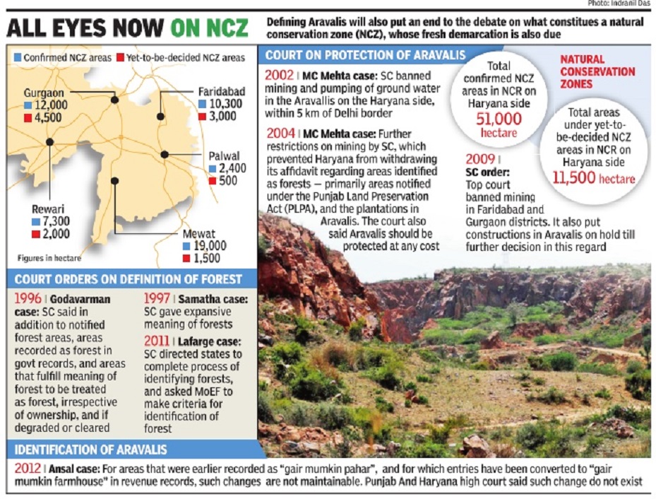
The Times of India
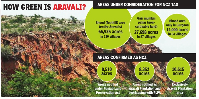
Bagish Jha
NCR May Lose Major Water Recharge Zones Due To Land-Use Change
Over 90% of foothills out of NCZ?
Large tracts of land in Aravali foothills are likely to remain out of the proposed natural conservation zone (NCZ), mainly due to change in land use of these areas in the past decades. Out of the 1,200 acres of bhood (a revenue term for foothills of Aravalis) in Gurgaon, only 80 acres are expected to be incorporated in NCZ, as land use of the rest of the land has been changed, purportedly to avoid classification as forest land that makes its use for any commercial project impossible.
An exercise for a fresh and scientific demarcation of NCZs has been on for months and a committee overseeing it is expected to submit its final proposal by April 13.
According to environmentalists, bhood areas are important water recharge zones and their conservation is important for recharging the groundwater of the entire NCR. They fear exclusion of bhood areas from NCZ will have a serious implication on the ecological balance of the region.
A government source said ownership of most of the land that may be excluded from the demarcation exercise, lies indirectly with realtors. “Developers are waiting for the NCZ notification to go ahead with their plan to build residential complexes in these area after changing land use from agricultural,“ the source said.
Additional chief secretary , department of town and country planning, P Raghvendra Rao said on Wednesday a final decision had not been taken yet and only discussions on definitions of certain revenue terms and how to assess areas under NCZ had taken place.“The district-level committee will finalise things and submit the proposal for demarcation of NCZ. There are differences of opinion on certain issues.We will look into them once the proposal was submitted by the district-level committee,“ said Rao.
He added, “We have an open mind and we are very concerned about environment and water recharge zones. So, if some issues were raised by anyone, we will consider them.“ He said NCZ areas had almost been finalised in Haryana's NCR districts except in some parts of Gurgaon and Mewat.
Forest officials have objected to exclusion of foothills from NCZ. “Land use was changes only on paper. Large tracts are still as they were decades back. These areas should be included in NCZ,“ said a senior forest official. A forest official clarified that areas like bhood, wasteland and paleochannels (streams that once existed but don't any more) are not notified as forest, so they can only suggest their inclusion.
“Nearly 11,910 hectares of land in Gurgaon is confirmed under NCZ and a large tract of land is under `yet to be decided' NCZ,“ Gurgaon deputy commissioner T L Satyaprakash said. Large parts of the land in the `yet to be decided' category are owned by private individuals and some of it under litigation, he added.
According to Satyaprakash, several years back, nearly 1,200 acres of land in Gurgaon was under bhood. “Over a period, land use changed and today most of this land is irrigated agriculture land in government records. Now, only 80 acres of this land remains as bhood,“ said Satyaprakash, He added that it would be difficult to include 1,200 acre of bhood under NCZ.
Similarly , wasteland and palaeochannel are not record ed in revenue records. “So we are not able to identify them.So, incorporating them in NCZ would be difficult,“ he said.
Originally, only land notified as forest, Aravali Plantation and land protected under Sections 4 & 5 of Punjab and Haryana Land Protection Act, 1990, water bodies and some other areas were to be identified as Natural Conservation Zone. “Later, on the request of government departments and some people, more areas were incorporated,“ said Satyaprakash. “The land use was changed illegally . Excluding areas under foothills will lead to destruction of Aravali and it will defeat the entire purpose of demarcating NCZ,“ said environmentalist Col SS Oberai.
[edit] December 2016: Sanction by NCR Planning Board
The Times of India, Dec 21 2016
Dipak Dash
NCRPB Decision Paves Way For Conservation Of Range
NCR Planning Board (NCRPB) put its stamp on bringing all noncultivable hill land, rocky and sandy areas in the ecologically sensitive Aravalis across NCR within the ambit of the mountain range. This decision paves the way for protection and conservation of Aravalis, which has been on the radar of real estate developers. No non-forest activity is allowed in Aravalis without prior permission of environment and forest ministry , meaning there will be hardly any scope for real estate or other construction work in such areas.
The decision was taken at the board meeting chaired by urban development minister M Venkaiah Naidu and attended by Haryana chief minister Manohar Lal Khattar besides representatives from Delhi and Rajasthan government.
However, what stumped many in the meeting was a request by a top Haryana government official reiterating the demand to remove restrictions on construction in Natural Conservation Zone (NCZ), which covers entire Aravali, lakes and water recharge zones. The Regional Plan of NCR, which has the consent of Haryana government, clearly treats the entire Aravalis as NCZ where construction is not allowed beyond 0.5% of the area.
The senior Haryana offici al raising the issue of doing away with this cap on construction shows how state bureaucracy is sticking to its demand of more construction in the ecologically fragile zone despite change of government. The earlier Bhupinder Singh Hooda government had unsuccessfully pushed for a similar course of action. Sources said Haryana officials want that allowing any construction activities in NCZ should be subject to approval from the environment ministry rather than having any overall limit on construction in such areas.
“The Board also clarified the position regarding demarcation of Aravalli range and delineation of NCZ. It said that the notification issued by the Ministry of Environment and Forests in 1992 has clearly explained for districts of Gurgaon in Haryana and Alwar in Rajasthan for regulating certain processes and operations in specified areas of Aravali range and this notification would guide identification and delineation of Aravalis in the entire NCR,“ an official statement from urban development ministry said.
Minister of state for urban development Rao Inderjit Singh said the curbs on construction in Aravalis and water recharge zones is essential for “sustainable development“ of the NCR. “It becomes our responsibility to protect this area for future generation,“ he told
[edit] Nature Education and Cure Centre
The Times of India, Demcember 13, 2016
Dipak Dash
In a controversial move, the Haryana forest department has proposed to issue a “corrigendum“ to de-notify 85 acres of forest land in the Aravalis in Gurugram where a `Nature Education and Cure Centre' will be set up in publicprivate partnership mode.
The land, along with another 500 acres, was repossessed by Haryana government in 2001 from Bharat Yatra Kendra, which included the “farm house“ of former PM Chandrasekhar, after his demise. The possession was transferred following a Supreme Court order. While 500 acres went back to the forest department, 85 acres, with nearly 20 structures, was restored to the gram panchayat.
The gram panchayat gave the 85 acres to the forest de partment to manage it, under section 38 of Forest Conservation Act. The entire 585 acres was notified as forest in 2004.The forest department later gave the land to Haryana Forest Development Corporation.
“Issuing corrigendum is an afterthought or a bureaucratic ploy to mislead political bosses to de-notify any forest land. This will open the floodgates for misuse, as both government agencies and private players are eyeing Aravalis for commercial exploitation,“ said R P Balwan, former conservator of forests.
He added there were efforts to use protected forest in Shivalik hill in the state for raising medicinal plants.“Under FCA, you cannot denotify a forest area and these cannot be used for commercial purpose. How can HFDC, which is only caretaker on behalf of forest department, moot a proposal to roll out a PPP project, which is nothing more than providing an entry to private players in forest area?“ Balwan said.
[edit] 2016: All non-forest activity banned
Dipak Dash, All land near Aravalis now protected, Dec 21, 2016: The Times of India
NCRPB Decision Paves Way For Conservation Of Range
NCR Planning Board (NCRPB) put its stamp on bringing all noncultivable hill land, rocky and sandy areas in the ecologically sensitive Aravalis across NCR within the ambit of the mountain range. This decision paves the way for protection and conservation of Aravalis, which has been on the radar of real estate developers.
No non-forest activity is allowed in Aravalis without prior permission of environment and forest ministry , meaning there will be hardly any scope for real estate or other construction work in such areas.
The decision was taken at the board meeting chaired by urban development minister M Venkaiah Naidu and attended by Haryana chief minister Manohar Lal Khattar besides representatives from Delhi and Rajasthan government.
However, what stumped many in the meeting was a request by a top Haryana government official reiterating the demand to remove restrictions on construction in Natural Conservation Zone (NCZ), which covers entire Aravali, lakes and water recharge zones. The Regional Plan of NCR, which has the consent of Haryana government, clearly treats the entire Aravalis as NCZ where construction is not allowed beyond 0.5% of the area.
The senior Haryana offici al raising the issue of doing away with this cap on construction shows how state bureaucracy is sticking to its demand of more construction in the ecologically fragile zone despite change of government. The earlier Bhupinder Singh Hooda government had unsuccessfully pushed for a similar course of action. Sources said Haryana officials want that allowing any construction activities in NCZ should be subject to approval from the environment ministry rather than having any overall limit on construction in such areas.
“The Board also clarified the position regarding demarcation of Aravalli range and delineation of NCZ. It said that the notification issued by the Ministry of Environment and Forests in 1992 has clearly explained for districts of Gurgaon in Haryana and Alwar in Rajasthan for regulating certain processes and operations in specified areas of Aravali range and this notification would guide identification and delineation of Aravalis in the entire NCR,“ an official statement from urban development ministry said.
Minister of state for urban development Rao Inderjit Singh said the curbs on construction in Aravalis and water recharge zones is essential for “sustainable development“ of the NCR. “It becomes our responsibility to protect this area for future generation,“ he told.
[edit] 2019: Haryana removes legal cover from 30,000ha of foothill land
Manvir Saini & Shilpy Arora, February 28, 2019: The Times of India
From: Manvir Saini & Shilpy Arora, February 28, 2019: The Times of India
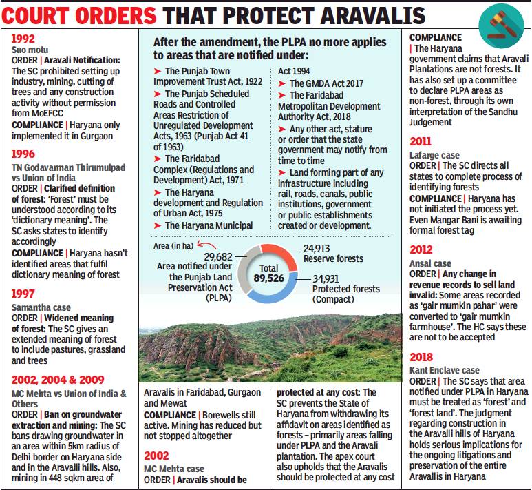
The Haryana Assembly passed the controversial Punjab Land Preservation (Haryana Amendment) Act, 2019 — which opens up nearly 30,000 hectares of protected land for development — with a voice vote on the last day of the Budget session, amid an opposition walkout.
The 118-year-old law, introduced by the British in 1900, restricts all non-forest activity in land along the ecologically fragile Aravali and Shivalik range foothills, under sections 4 & 5. Wednesday’s amendment puts municipal areas and those notified under master plans (effectively, all urban areas) out of the law’s ambit. As a result, Gurgaon, which is notified under three master plans, will go entirely out of the purview of PLPA.
So will most of Faridabad, where the Haryana government recently said it wants to build a new city over an area of 55,000 hectares. The total area under PLPA in Gurgaon is 6,869 hectares. In Faridabad, it’s 4,227 hectares. The total area notified under PLPA in Haryana is 29,682 hectares.
Legal cover off for foothill land, greens fear threat to Aravalis
Haryana’s Amendment To Law Leads To Outcry
The amendment, which nullifies all notifications under PLPA from the time Haryana was established (November 1, 1966), also gives post-facto approval to existing violations and encroachments, which means illegal constructions in PLPA notified areas will now get legal sanctity. This will have implications for all legal cases and complaints filed citing PLPA over the decades against illegal construction in the state.
It remains to be seen how the amendment affects the sprawling, high-profile Kant Enclave in Faridabad, which was built in a protected area and is facing a legal battle in the Supreme Court. Another change the amendment brings about is that it gives the Haryana government discretionary power to exclude, rescind and exempt any area that continues to come under PLPA.
The opposition claimed over 74,000 acres of protected land would now be made available to real estate developers and miners, a charge the government refuted, saying the Punjab Land Preservation (Haryana Amendment) Act was in the interest of people.
“This is the demand of the day,” Haryana chief minister Manohar Lal Khattar said in the assembly. “As of now, we are facing litigation for Kant Enclave and Huda sectors. Nearly 16 districts are covered and we have become helpless, hence this amendment was necessary. We have taken care of protected areas.”
Opposition legislators had asked the CM to form an allparty committee to study the ramifications of the amendment before tabling the bill for discussion. They also strongly sought an explanation for the need to implement the changes in the law retrospectively.
The CM had defended the amendment to the PLPA during the debate on the governor’s address last week. “For decades, Aravalis saw illegal mining. Now, putting a single brick has become a difficult in the districts of Faridabad, Mahendergarh, Rewari, Gurugram and Bhiwani. The amendments are targeted to improve the system, that too without damage to the environment,” he had said.
On Wednesday, after Speaker Kanwar Pal Gujjar asked forests and wildlife minister Rao Narbir Singh to present the bill before the House, INLD’s Julana MLA Parminder Dhull urged the government to withdraw the bill without discussion. The amendment, he said, would result in a constitutional crisis and could even lead to legal complications.
Congress Legislative Party leader Kiran Choudhary and fellow MLAs — former speaker R S Kadian, Karan Singh Dalal and Lalit Nagar — strongly opposed the bill. The party’s Palwal MLA, Karan Singh Dalal, accused some Haryana ministers and the CM’s office of playing into hands of the mining and builder mafia.
Environmentalists said the bill wasn’t an amendment but amounted to a cancellation of PLPA. “This bill is essentially a repeal of the PLPA. The bill has lifted the most important legal protection to the Aravalis in south Haryana and many parts of Shivaliks to open it for real estate development, mining, and whatever the state fancies,” said Vivek Kamboj of Haryali (an environmental NGO).
“The bill is the most deadly assault on the Aravalis in the 52-year history of Haryana and is the darkest time for environmental conservation in the state. The numerous amendments combined will effectively nullify the PLPA itself. This is an attempt to give legal sanction to all construction, which have so far been prohibited under PLPA 1900,” said Chetan Agarwal, a forest analyst.
Legal experts, though, said lifting PLPA will not give sanction to unauthorised constructions. “The amendment is in contempt of various Supreme Court orders, including the one given in the Kant Enclave case recently, wherein the court reiterated that all PLPA areas are forest. In 2002, 2004, 2009 and 2018, during various hearings, the apex court said that PLPA areas are to be treated as forest, and therefore, protection of the Forest Conservation Act, 1980 apply to PLPA areas,” said Lt Col Sarvadaman Singh Oberoi (retired), a legal expert.
Citizens’ groups have also been protesting against the bill. “The Aravalis act as green lungs of NCR. They are crucial for recharging groundwater,” said Aparna Kapoor, a resident of DLF Phase III.
WHAT IT MEANS
29,682 ha of protected land in Aravali, Shivalik foothills of Haryana now opened for development
Includes 6,869 ha in Gurgaon, nearly 4,200 ha in Faridabad. Sacred grove of Mangar Bani also under threat
Black day for environment, say activists & Oppn. Govt calls it a much-needed move
[edit] 22,425 hectares in NCR get ‘protected forest’ tag/ 2024
Ipsita Pati, March 4, 2024: The Times of India
Gurgaon : Around 85% of the Aravali land, which was to be included in the compensatory afforestation plan, has finally got legal cover as ‘protected forest’. A total of 22,425ha of land spread across five districts of Haryana have been notified now.
The gain for the Aravalis, which have degraded over the years due to mining and construction, comes at the cost of tropical rainforests in Great Nicobar. In Nov 2022, the ministry of environment, forest and climate change (MoEFCC) had cleared the decks for a mega project to build an international airport, a shipment port, a power plant and a township over 160sq km of land, over 80% of which are forests on the island. Compensatory afforestation to make up for this loss of forest in Nicobar was decided to be carried out in the Aravalis, some 2,400km apart. The process to identify Aravali land for compensatory afforestation began in Feb 2023.
The five districts, which have been included in the plan, are Gurgaon, Nuh, Rewari, Mahendergarh and Charkhi Dadri. Till now, 22,425ha have been notified as ‘protected forest’ and 1,928ha will get the tag soon.
In Gurgaon, 1,194ha have been notified. A total of 11,118ha got the protected tag in Nuh, followed by Rewari (3,582ha) and Mahendergarh (6,530ha). An additional 1,306 ha in Gurgaon, 24ha in Mahendergarh and 596ha in Charkhi Dadri will get the tag soon.
Any non-forest activity such as construction, cattle grazing and pasturing, fishing, hunting is barred in these areas. Exceptions are only allowed if the forest department gives its permission.
“We will also notify the remaining 1,647ha of land to achieve the target. We are also in the process of finalising the proposal for restoration and compensatory afforestation action plan. This will be submitted to the forest ministry for final nod,” said a forest official.
The notification will be a fillip to Haryana’s recorded forest area. According to a Forest Survey of India (FSI) assessment in 2021, the state has 34,500ha of recorded forest cover, but another 1.3 lakh ha are not officially tagged, keeping them out of the purview of any protection.
The state is fast losing forest cover. The same report by FSI had noted that Gurgaon alone lost 247 ha of forest cover between 2019 and 2020.
In Gurgaon, the notified Aravali forest areas under the swap are spread across six villages — Ghamroj, Alipur, Tikli, Sakatpur, Gairatpur Bas and Aklimpur. Another 34 villages in Rewari, 68 villages in Nuh and 53 villages in Mahendergarh have also got protected land. Earlier, these areas were owned by village panchayats, and thus the forest department was unable to protect them from getting encroached.
Meanwhile, activists questioned how compensatory afforestation in Haryana would help reduce the environmental impact of the loss of greenery in Nicobar. “Why has govt not included Faridabad’s forest areas in the notified land? Several real estate firms have bought land in the Faridabad Aravalis. Why is govt not trying to save those areas?” asked Vivek Kamboj, an environmentalist.
Responding to this, a forest official said they didn’t include the Faridabad Aravalis as there wasn’t a suitable continuous tract of forest land for afforestation.
[edit] Court judgements
[edit] NGT: 2013-22
Ipsita Pati, Dec 13, 2022: The Times of India
From: Ipsita Pati, Dec 13, 2022: The Times of India
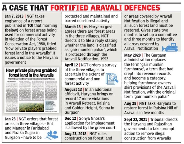
Gurgaon : A landmark journey at the National Green Tribunal (NGT) that began nine years ago with a TOI report, morphed into a petition, and led to several significant measures to protect forest areas in Aravalis, including Mangar, drew to a close this month. It left the vulnerable hill ranges significantly better fortified against any onslaught of illegal construction.
Wrapping up proceedings on December 9 in a case that came to be called Sonya Ghosh vs State of Haryana, the NGT directed the Haryana and Rajasthan governments to set up a monitoring committee and conduct periodic reviews till all encroaching construction is removed from protected Aravali land in three Haryana districts – Gurgaon, Faridabad and Nuh – and Alwar in Rajasthan on land classified as ‘gair mumkin pahar (uncultivable hill)’.
The tribunal also askedthe chief secretaries of both states to ensure compliance with the directions.
Among the most significant outcomes of the NGT proceedings was the deletion of the term ‘gair mumkin farmhouse’ from revenue records by the Gurgaon administration in 2020 and their replacement with ‘gair mumkin pahar’ (uncultivable hill). The term, which found its way insidiously into the records, allowed farmhouse owners to circumvent provisions of the Aravali Notification 1992 that recognises ‘gair mumkin pahar’ as protected land.
The NGT admitted Sonya Ghosh’s petition on December 12, 2013. But the start of proceedings predated the petition. On January 7 that year, the tribunal took cognisance of a TOI report on illegal construction on forest land in the Aravalis, titled ‘How private players grabbed forest land in the Aravalis’, and sought a response from the Haryana government.
The court followed that up by ordering a stop to non-for-est activity and a survey of forest land in three affectedvillages – Kot and Mangar in Faridabad and Roz Ka Gujjarin Gurgaon – before admitting an impleadment applica-tion by Ghosh that winter, Aagney Sail, the petitioner’s counsel, told TOI.
The first judgment in the case came in 2018, when the NGT declared that any construction on land covered by the Aravali Notification is illegal and directed the Haryana government to restore the forest in encroached areas like Raisina Hill in Gurgaon. “Construction on forest land or areas covered by Aravali Notification is illegal, and such forest land has to be restored… any construction raised on the forest area or the area otherwise covered by (Aravali )notification without permission of the competent authority (after the date of the notification) has to be treated as illegal and such forest land has to be restored,” the NGT stated in its ruling.
The NGT gave the Haryana government two months to set up a committee and three months to identify all forest land covered by the Aravali Notification. The committee was,however, formed only in July 2019.
Demolition notices were issued to farmhouses, but in most cases, this wasn’t followed up by an actual demolition. The deletion of the term ‘gair mumkin farmhouse’ in May 2020 removed the shield farmhouses had despite being illegally built. Though the terminology had no impact on the ownership, it did away with equivocation that ‘gair mumkin farmhouse’ created and brought the land in question under the clauses of the Aravali Notification to disallow any ‘non-forest’ activity. Demolitions in Raisina in compliance with the NGT order have only recently begun. Disposing of the petition on December 9, an NGT bench of chairman Adarsh Kumar Goel, judicial member Sudhir Agarwal and expert members A Senthil Vel and Afroz Ahmad asked the Haryana and Rajasthan government to continue with remedial action in accordance with the law. “Having monitored the mat-ter for almost 1o years, the encroachers having been identified and the states of Rajasthan and Haryana having constituted their monitoring mechanism, it will be appropriate to direct that further remedial action may be taken by the states of Rajasthan and Haryana in accordance with law,” stated the judgment.
The tribunal noted that government departments had worked to remove encroachments in their jurisdiction and submitted actiontaken reports. Over the nearly 10 years, there were 71 hearings of the case in the NGT.
According to a forest department survey, at least 500 farmhouses have been built illegally on Aravali land in Gurgaon, concentrated in areas like Gwalpahari, Abheypur, Gairatpur Bas, Sohna, Raisina and Manesar. A detailed list of these constructions was submitted to the NGT in the Sonya Ghosh case last year. The report also had details of the total area occupied by them and their locations.
[edit] Damage, the extent of
[edit] ‘Damage to Aravallis scary’: SC
Krishnadas Rajagopal, SC orders demolition of illegal structures, September 11, 2018: The Hindu
‘Damage to Aravallis scary’
The Supreme Court on Tuesday ordered the demolition of structures built illegally by a prominent builder in the protected forests of the Aravallis, noting that ecological damage done by colonisers to the ancient hills was irreversible and “quite frightening.”
A Bench of Justices Madan B. Lokur and Deepak Gupta ordered that all structures built after August 18, 1992 in the area known as ‘Kant Enclave’ at Anangpur in Faridabad district of Haryana should be demolished.
They have to be razed down by December 31, 2018, the court said.
It held that these illegal structures defy a Haryana government notification of August 18, 1992, issued under the Punjab Land Preservation Act, declaring the area as forest land and fragile.
Granted exemption
The court, however, ordered not to disturb constructions made between April 17, 1984 and August 18, 1992. These structures were built on the basis of an exemption given to Kant &Co by the State’s town planning department under the Haryana Development and Regulation of Urban Areas Act of 1975 for setting up a “film studio and allied complex” in the area. The exemption was removed when the August 18, 1992 notification kicked in.
Kant & Co, the court ordered, should pay a full refund to investors to whom they had already transferred the land. The builder has to pay interest at 18% per annum from the date of the investment.
Dept. pulled up
The court pulled up the State town and country planning department for supporting the illegalities. The department was myopic and brazen to push its agenda in favour of the builder no matter what it cost to the environment and ground water in the area.
The Bench accused the department of having “completely vitiated the efforts of the forest department as well as the orders of the Supreme Court.”
“There is no doubt that at the end of the day, the State of Haryana comes out in very poor light and must be held accountable for its conflicting and self-destructive stand,” Justice Lokur, who wrote the 81-page judgment, observed.
“It is not only the future generations that have to pay a heavy price for this environmental degradation, but even the present generation is paying a heavy price for the environmental and ecological degradation inasmuch as there is an acute water shortage in the area as prophesied by the Central Ground Water Board,” he said.
[edit] 2018/ A fourth of Aravali hills in Rajasthan gone forever
The Supreme Court-appointed central empowered committee (CEC) on Tuesday startled the apex court with its revelation that 31 of 128 hills in the Aravali range in Rajasthan had vanished in the last 50 years due to massive illegal quarrying, compelling the court to direct the state to stop mining in a 115.34-hectare area in the region within 48 hours.
A bench of Justices Madan B Lokur and Deepak Gupta expressed shock at how the hills had “vanished” and directed the chief secretary of Rajasthan to take immediate steps to stop illegal mining in the state and file an affidavit by October 26 on compliance with its order.
The court said the state had failed miserably to protect the hills and allowed mining companies to carry out illegal operations for royalties at the cost of destruction of nature. The court said the disappearance of hills in the bordering area of Delhi might be one reason for growing pollution levels and dust storms in the capital as the hills used to block pollutants.
“Thirty-one hills have disappeared. If hills disappear in the country, what will happen? Have people become Hanuman and are running away with the hills? More than 20% hills have vanished in the state,” the bench observed.
The state government admitted that illegal mining was still going on despite the apex court’s orders.
Additional advocate general of the state S S Shamshery, however, contended that action was being taken against mining companies and FIRs were being lodged against them.
The court pulled up the Rajasthan govt, saying, “For the sake of a few mining companies, you are putting lives of lakhs in danger”
SC: If you start removing hills, pollution will come to Delhi
The court was not satisfied with the assurance and passed the order for stopping all mining operations in two days.
“Hills were created by God for some reason. If you start removing hills then pollution from other areas will be coming to Delhi and that may be one of the reasons for increasing pollution levels in Delhi. For the sake of few mining companies, you are putting life of lakhs of people in danger. Damage has already been done. The devastation caused is apparent and you can seen it while travelling from Delhi to Jaipur,” the bench said.
On a query from the court on how much royalty it is getting from the mining companies, advocate A D N Rao, appearing for CEC, said the state is getting Rs 5000 crore from the companies. Rao told the bench that the apex court’s order was not being followed by the state and pleaded the court to pass stringent orders.
“You give this Rs 5,000 crore for health of the people of Delhi. Hospitals in Delhi are over-crowded, people are dying here due to pollution,” the bench said.
In its report, CEC said illegal mining was going on in 15 districts in Rajastan and districts of Alwar, Dungarpur and Sikar were worst affected. It said illegal mining was going on over an area of 115.34 hectares. It said the majority of mining leases in the state had been granted in “clusters”. The court posted the case for October 29 to examine compliance of its orders.
[edit] Hundreds of hillocks flattened, sandstorms reach NCR/ 2023
Shoeb Khan, June 5, 2023: The Times of India
JAIPUR: Scores of Aravali hills have vanished in the past 20 years due to unchecked mining and urbanisation, threatening the flora and fauna of one of the world’s oldest mountain ranges and leaving the path open for sandstorms from the Thar desert to hit the national capital region (NCR) and western UP and increased conflicts with animals, warns an ongoing study on the state of the hill range. The findings have come in a research of the Central University of Rajasthan (CURaj), which has identified over 31 hills in the upper Aravali range that have disappeared in the last two decades, besides “hundreds of hills” in the lower and middle levels.
“The systematic disappearance of hills at the upper level was recorded in Naraina, Kalwar, Kotputli, Jhalana and Sariska with heights of 200 metres to 600 metres above sea level. However, the count of vanishing hills at the lower and middle level, with heights between 50 to 200 metres above sea level, has yet to be completed. All I can share now are the preliminary results which are very alarming,” said L K Sharma, head of department of environmental science, CURaj.
The denudation has led to man-animal conflicts as leopards, chinkara and sambhar deer, which find home in the hills, enter human settlements. Rare plants like neel, chonakurinji and karun kurinji also face wipe-out threats.
[edit] 1975 – 2019
Ipsita Pati, June 18, 2023: The Times of India
Gurgaon : Between 1975 and 2019, nearly 8% of the Aravali hills have disappeared, says a study of the ranges across four states, projecting the losses to rise to around 22% by 2059 if “explosive” urbanisation and mining continue at the current pace, reports Ipsita Pati.
Delhi-NCR, according to the researchers, will be at the heart of both the cause and effect of this loss. The Aravalis, the study infers, are most vulnerable here, and as more hills get flattened, they will open a “gateway” for the Thar desert to expand towards the national capital area,which implies a more dusty and arid landscape, a rise in pollution levels and more erratic weather patterns.
[edit] Details
Ipsita Pati, June 18, 2023: The Times of India
From: Ipsita Pati, June 18, 2023: The Times of India
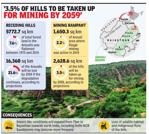
Gurgaon : Nearly 8% of the Aravali hills have disappeared between 1975 and 2019, says a study of the ranges across four states. Researchers from the Central University of Rajasthan (CURaj) studied satellite images and landuse maps between 1975 and 2019 to come up with estimates. Their paper — titled Assessment of Land-Use Dynamics of the Aravalli Range — was published in the journal Science Earth Informatics this January.
Data analysed by researchers showed that 5772. 7 sqkm (7. 6%) of the Aravali ranges was flattened in the 44-year period they studied. Of this, nearly 5% (3,676 sqkm) of the hills was converted into barren land and another 776. 8 sqkm (around 1%) into settlements. The projected loss by 2059 of total Aravali area is 16,360 sqkm, according to the report.
In this time period, the average deforestation rate was 0. 57% annually, the study’s lead researcher Laxmi Kant Sharma told TOI. If this continues, the landscape in swathes of north India will become arid and desertification will set in, according to the study.
“…change from 1975 to 2019, which shows that the Aravali range is passing through significant deterioration, where biodiversity loss is prominent… These deteriorated hill gaps have opened a gateway for desertification in the northeast part of Rajasthan to Delhi,” the study says.
A total of 2,269 hills make up the Aravalis that extend from Gujarat to Delhi, via Rajasthan and Haryana. The hills and the forests of the ranges are natural barriers to the expansion of the Thar desert. Unchecked mining for stones and sand has been accelerating the rate of damage to the Aravalis over the decades. In October 2018, a central empowered committee appointed by the Supreme Court informed a bench of Justices Madan B Lokur and Deepak Gupta that one-fourth of the Aravali ranges in Rajasthan (31 out of 128 hills in the state) had disappeared over a 50-year period because of illegal mining.
In adjacent south Haryana,despite the Supreme Court banning mining in Gurgaon, Faridabad and Nuh in 2009, it continues to make gashes in the ranges, operating through an entrenched network.
Last July, a Haryana Police DSP was crushed to death by the driver of a truck carrying illegally mined stones in Nuh. Earlier this week, a government team was attacked by 10-12 stick-wielding men at Sancholi village in Sohna. The CURaj study says 1,852 sqkm of the Aravalis is currently being mined in nine areas – Gurgaon, Faridabad, Rewari, Jaipur, Alwar and Ajmer. There are 4,150 mining leases, of which just 288 have environmental clearance, the study notes, citing data released by the Comptroller and Auditor General of India (CAG) in a report in 2017. Sharma, who is also the head of department of environmental science at CURaj, said that by the estimates of the study, 3. 5% (2,628. 6 sqkm) of the total Aravali area will be used for mining by 2059.
[edit] Desertification
[edit] Aravalis are losing power to check desert spread
Natural Forests Are Shrinking In Areas That Are Holding Up The Ecosystem
The threat of desertification, which has loomed for decades over the exploited Aravali ranges, is growing, and its most palpable manifestation is in naturally forested sections that have started to lose their vegetation, particularly in Haryana, a study has said.
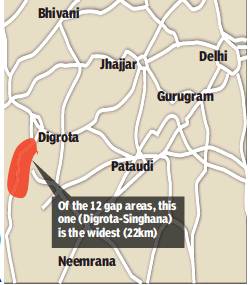
As a result, the hills are losing their capability of acting as an effective green barrier to the expansion of the Thar desert towards southern Haryana and Delhi. The study, conducted by researchers at the Wildlife Institute of India (WII), points out a dozen gap areas — forested areas that fill intervals in the rocky ranges — in Haryana and Rajasthan whose green cover has declined.
[edit] Ecological damage
[edit] Damage to the Aravalis damages the region
From: How shrinking Aravalis opened giant gateway for dust pollution in Delhi-NCR, September 15, 2018: The Times of India
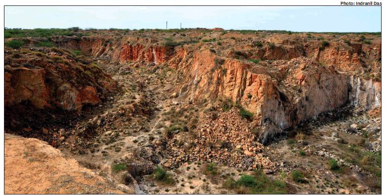
From: How shrinking Aravalis opened giant gateway for dust pollution in Delhi-NCR, September 15, 2018: The Times of India
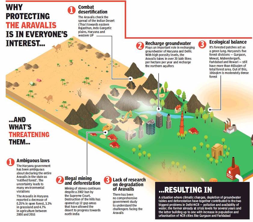
From: How shrinking Aravalis opened giant gateway for dust pollution in Delhi-NCR, September 15, 2018: The Times of India
For many hundreds of years, the Aravali hills have been instrumental in shaping the climate of the upper Indo-Gangetic plain. From rainfall, temperature and aquifer recharge to soil conservation, biodiversity and ecology, every factor has been dependent on this millennia-old range. But despite their life-sustaining and life-conserving qualities, the Aravalis and their tropical dry-deciduous forests have gained very little attention.
And that’s because degradation of these hills — the range has shrunk by 40% over the last four decades, from 10,462 square kilometres in 1972-75 to 6,116 sqkm today — has always been viewed as an issue localised to a few districts of south Haryana, even though it affects the entire Indo-Gangetic plain, including Delhi-NCR, parts of Punjab, and as far as western Uttar Pradesh.
The Aravali range functions as a check on the movement of sand from the Thar Desert to Delhi-NCR, Haryana and western UP. Besides playing a key role in recharging aquifers and conserving soil, it also curbs wind velocity and evaporation to ensure sufficient rainfall in the region. Moreover, it helps prevent floods and the worst effects of climate change in the Great Indian Desert, by acting as a barrier to rain-bearing winds heading towards the deserts of Rajasthan.
Onward march of the desert
A study by the Haryana government, conducted with the help of data acquired using remote sensors, showed there are at least 12 breaches in the Aravali range totalling 93km. These gaps extend from Magra peak in Ajmer, Rajasthan, to the rises in Madhogarh and Khetri in Jhunjhunu district, and the hills towards the north of Mahendragarh district in Haryana. And it is through the longest of the gaps (22km), called Singhana-Digrota, that dust storms blow into Delhi-NCR. The affected area under sand dunes in the 12 gaps is 5,680 sq km.
In another study, carried out by the Wildlife Institute of India (WII) in 2017, it was revealed that sand dunes have been found in Harchandpur village of Sohna, as close as 20km from Gurgaon and 60km from Delhi. Worryingly, the sands of the Thar are inching ever closer to the National Capital Region.
Dr Kushagra Rajendra, head of the department, Amity School of Earth and Environmental Sciences, highlighted the critical role played by the Aravalis in checking both wind velocity and evaporation to prevent sand migration from the Thar desert. “A desert is created when soil for a long time is devoid of moisture, which binds the soil grains and allows vegetation to grow and cover the ground. For many years, the wellforested Aravalis acted as a constraint and checked the spread of the Indian desert towards upper Indo-Gangetic plains,” he explained. “The desert is in the west from Budelkhand and Malwa plateau is in the east. Before monsoon, the wind pattern is directed from the desert towards the plateau and Gangetic plains. It carries a lot of dust and sand along with wind, but Aravalis check the wind velocity.”
Indeed, at one time, the forests in the Aravalis would give rise to seasonal rivers. But the gradual degradation of the range, over the last 40-50 years, has accelerated the spread of desert. “It has led to desertification on the western side, and flooding in eastern Rajasthan, as winds carrying rain can easily move from west to east.” The Aravalis, Dr Rajendra said, are no longer an effective barrier against extreme weather events due to rampant mining, extensive land use change, and exploitation of the landscape.
Retreat of the rains
According to a study conducted by the department of geography at Mohanlal Sukhadia University, Udaipur, the Aravalis would attract rainfall towards a swathe of north and northwest India for 60 to 80 days a year, around 40 years ago. The hills drew both the Arabian Sea and Bay of Bengal monsoon currents, and it was in this hilly region where both currents met. “These monsoon currents, after entering the coastal areas, used to blow right up to the foothills of the Aravalis and start ascending the green and (moisture-laden) hill slopes, causing effective condensation process and leading to excess (to normal) rainfall,” the report stated. “However, due to deforestation, the trans-evaporation process has altered, decreasing the total number of rainy days from 60 to 80, to 18 to 30 days per year.”
The Aravali hills help perform a couple of important functions as well, drainage of excess water and recharge of groundwater. A Central Ground Water Board (CGWB) report released in June 2017 referred to the hills as “major recharge zones for surrounding plains (with which) aquifers in Aravalis are interconnected, and any alteration in the pattern can disturb the groundwater condition of the entire south Haryana and Delhi.” Experts have said degradation is to blame for the decrease in soil fertility in the upper northern plains, and the increase in salinity in the groundwater. “The uppermost layer of the soil is the most fertile. As we are losing forest cover in the Aravalis, massive soil erosion is taking place, thereby eroding the upper layer of the soil,” said Dr Anil Kumar Singh of the National Academy of Agricultural Sciences, Delhi.
Soil salinity, Dr Singh added, is responsible for reducing soil fertility which, in turn, “adversely” affects the overall quality of the soil. “Soil salinity is caused mainly by three factors in this region — inherent salinity, irrigation by saline water, and deterioration of groundwater quality,” he explained.
No strong laws
In 1992, the Aravali ranges in Gurgaon and Alwar (Rajasthan) were notified as an ecologically sensitive area by the National Capital Region Planning Board. However, successive governments in Haryana have failed to give these hills the status of ‘notified forest’. Besides, refusal to grant ‘deemed forest’ status, exclusion of the entire range in the ambit of NCZ (natural conservation zone), and failure to enforce the Tree Act (in force in Delhi to protect the Ridge, a part of the Aravalis), have contributed to the fragile state of the range.
“The problem is that the Haryana government hasn’t taken enough steps to protect the Aravalis, which play an important role in maintaining ecological balance in the entire northern plains,” summed up Ajay Kumar Saxena, programme manager, forestry team, Centre for Science and Environment.
Some have stressed the importance of reviving the Aravalis as part of the disaster management plans of all affected states. Among them is Rajendra Singh, winner of the prestigious Stockholm Water Prize in 2015, who told TOI, “Degradation of the Aravalis and massive deforestation has already led to a lot of disasters, including desertification in Delhi and Haryana, droughts in Haryana, western UP and Delhi, and floods in the desert, as it is changing the monsoon pattern of the entire upper northern plains. Governments of all affected states should come together and work on a war footing to save the Aravalis,” urged Singh, popularly known as the ‘Water Man of India’. Download The Times of India News App for Latest City News.
[edit] Green cover, increase/ decrease in
[edit] 400% increase in 1990s, decline after 2000
Report Claims Plantation Drives Were Shot In Arm For 7 Districts
The state forest department on Monday released a report by HARSAC (Haryana Space Application Centre) on its website, highlighting a fourfold increase in green cover in the Aravalis during 1990s.
The report, including satellite images, was made public at a time when the department is planning an audit of plantation drives in the Aravalis in the last 26 years. The HARSAC report suggests forest cover across seven districts -Gurgaon, Bhiwani, Faridabad, Rewari, Nuh, Palwal and Mahendergarh -had shot up to 42,000 hectares in 1997 from around 10,000 hectares in 1990. Apart from the state government, European Union had also allocated a huge grant (Rs 175 crore) for the Aravali Project, which boosted greenery in the 1990s, before forest co ver declined in the past decade.
According to the report, in Gurgaon alone, forest cover had increased from 1,302 to 3,981 hectares -a rise in 2,679 hectares -during the period. While dense forests rose from 430 to 2,286 hectares, open forests rose to 1,295 hectares from 872.
“The Aravali Project has helped increase green cover in the seven districts. We're now working on eco-restoration of the area, to allow natural vegetation,“ said M D Sinha, forest conservator (Gurgaon circle).
Regarding the fall in forest cover after 2000, former conservator R P Balwan said, “The overall forest cover declined sharply across Haryana due to destruction of strip green areas for so-called infrastructure development. In south Haryana districts under the project, mining, construction and felling has hurt environment.“
[edit] Groundwater pollution
[edit] 2016: CGWA partially concurs with reports
The Times of India, Apr 20 2016
'Aravali waste spill A spoils groundwater'
Bagish Jha The Central Ground Water Authority (CGWA), in the affidavit filed before the National Green Tribunal (NGT), has partially agreed to the allegation in a petition that the groundwater in Aravalis is being polluted by untreated waste lying near Bandhwari waste treatment plant on Gurgaon-Faridabad road.
In its three-page affidavit, filed on the direction of the NGT, CGWA has agreed to most of the allegation related to unscientific dumping of waste around Bandhwari waste plant by municipal corporations of Gurgaon and Faridabad. It also taken notice of the claims that leachate has contaminated ground water, thus affecting Gurgaon, Delhi and Faridabad water tables.
The CGWA affidavit has accepted that report published in TOI on September 8, 2015 that the pit where a lake of leachate has been created us ed to be a seasonal water body of the village, and that the contamination might have even made the water carcinogenic.
The affidavit also put the onus of providing an explanation to the claims made in the petition on MCG. “Municipal solid waste management falls under the purview of the local municipal bodies. The concerned local municipal bodies are believed to be exercising their constitutional powers and functions to enforce the municipal lawsrules. The municipal bodies have since been made parties in the matter, they will explain their stand,“ reads the affidavit.
[edit] Places in need for conservation
[edit] Aravalis, Lake Damdama: Aravali’s Last Lake in Danger
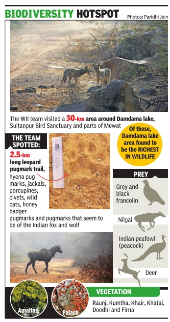
Haryana to allow houses on hillock next to Damdama Any structure on the hill will block flow of rainwater, thereby endangering the future of the water body Dipak Kumar Dash | TNN
Damdama (Gurgaon): Another lake in the Aravalis may soon be consigned to oblivion. If Surajkund and Badhkal lakes succumbed to mining activities in the Aravalis, Damdama, the last surviving water body in the region, may also go dry thanks to the government’s short-sighted policy that will soon facilitate construction in the area.
The revenue department in Gurgaon has almost completed the consolidation (Chakbandi) of plots on a hillock — Roj Ka Gujjar — spread over 5,744 acres adjacent to the lake. This will allow owners to construct houses on their plots. And any structure on the hillock, say environmentalists, will obstruct smooth flow of rainwater, the only source of replenishment, to the lake, almost 40 km from the national capital.
‘‘Any activity in the region will mean that the flow of rainwater to the lake will stop or would be adversely affected. Moreover, people will end up extracting groundwater, which is equally damaging,’’ said R P Balwan, former conservator of forest of southern circle (Gurgaon).
Originally, the hill was commonly owned by residents of 12 villages in the region. ‘‘But almost 90% of the land on the hill has already been sold to outsiders, mostly from Delhi. This had been happening since 1980s. The original owners have sold their shares, though those were not identified. After the consolidation, plots will be demarcated and given to the new individual owners. Those who have bought land are rich and influential people,’’ said a revenue department official.
However, he added that when the department was about to notify consolidation, a scam was detected and the process was put on hold. ‘‘We found that the total land sold was more than the actual area of Roj Ka Gujjar. An additional 631 acres had been sold. The regional commissioner has ordered us to halt the process of handing over of the plots,’’ he added.
The list of discrepancies doesn’t end there. The Ministry of Environment and Forest (MoEF) had written to Haryana government in December 1992 mentioning that all the areas notified under Punjab Land Preservation Act (PLPA) are forests and such areas cannot be used for non-forestry activities without prior permission from the ministry. Though Roj Ka Gujjar is covered under PLPA, its land is now up for consolidation.
Balwan said that construction of any dwelling unit, road or path, electricity poles has also been prohibited. Moreover, the hillock was also covered under Aravali plantation, which has been declared as deemed forest by the Supreme Court. ‘‘The revenue department should not have allowed the sale and purchase of common land since it was not demarcated or fragmented,’’ he added.
But, people who have bought land adjoining the half-dry waterbed of Damdama have started constructing boundary walls. ‘‘In the last few years, more people have bought land around the lake. Things would get worse when more people will occupy the hilltop,’’ cautions Bane Singh, a resident of Damdama village.
Sources said that the revenue department wants to ensure that the drains and streams, which carry rainwater to the lake, are not blocked. ‘‘We have included this in the consolidation scheme so that the natural water supply to the lake is not disturbed. Though consolidation would be finalised soon, land owners would have to get approval for anything they do on their land,’’ said a senior revenue department official.
[edit] Wildlife
[edit] 2017: wildlife density in five districts
In the first survey of its kind on population density of wild animals in five districts of Haryana, the Wildlife Institute of India (WII) has found leopards occupy a 200 square km area in these parts of the Aravalis. And the terrain in Gurgaon and Faridabad districts happens to be their core area.
“Total area under leopard occupancy was estimated to be 200.9 square kilometres.Sites namely Gamroj (Bhondsi), Raipur (Raisina), Mangar, Gothda, Badhkal, Kotla Kansali, Nimatpur (Nayaan), Khol and Panchota have higher psi (population stability index) estimates,“ states the survey report, which was released by chief minister Manohar Lal Khattar and Union environment minister Harsh Vardhan.
“Out of five districts -Gurgaon, Faridabad, Mewat, Rewari and Mahendergarh -the occupancy of leopards is the highest in Gurgaon and Faridabad. Moreover, the core zone (highest used region by the leopard) is also in these two districts,“ said an official of WII who did not wish to be named.
Besides field sampling and analysis, WII used 12 camera traps to track the sightings of wild animals in the Aravalis. As many as seven sightings of leopards were reported in the camera traps within 30 days in October 2016. Moreover, sightings of 13 other species were recorded in the camera traps -seven of striped hyena, nine of golden jackal, 55 of nilgai, seven of palm civet, 14 of wild pig, 55 of rhesus macaque, 57 of peafowl and 12 of the Indian crested porcupine. The camera traps were put up in Bhondsi, Gamroj, Mangar, Bandhwari, Wazirabad, Gothda and Anangpur.
The survey found the jackal to be the highest-occurring carnivore species, followed by the hyena, and nilgai was found to be the highest occurring ungulate in the area. “Jackals are present in almost every grid with 92% occupancy ,“ the report states.
MD Sinha, conservator of forests (Gurgaon circle), said there has definitely been an increase in wildlife population, particularly that of leopards in the area. “There is an area of over 35,000 hectares around Gurgaon, which is very sensitive for wildlife.Seven sightings of big cats in 12 camera traps is a very good number,“ he told TOI.“Also, four successful leopard rescues have been conducted in the last six months by the forest department. There is an immediate need to protect the green cover and lay out a long-term wildlife management plan as wildlife is continuously increasing in the Aravalis,“ he added.
Asked if a wildlife census will be conducted in the Aravalis, Sinha said, “The department has already submitted a plan to conduct a comprehensive study and census of wildlife. We have already submitted a proposal to put radio collars on wild animals.“ The WII report also recommended an immediate end to mining activities in Haryana.
[edit] 2019,2020: status of wildlife
Ipsita Pati, January 13, 2021: The Times of India
A wildlife survey has found that the unprotected forest tracts in the Aravalis in Gurgaon and Faridabad harbour a rich variety of mammals, more than Asola Bhatti, the contiguous tract in Delhi that enjoys the status of a wildlife sanctuary.
During the survey, carried out over 2019 and 2020 by wildlife researchers with the support of several NGOs, striped hyenas, leopards, black-naped hares, Indian crested porcupines, small Indian mongooses and golden jackals were found to have healthy populations in the Gurgaon Aravalis. Besides, the wildlife density in the Gurgaon section of the Aravalis and Mangar Bani was inferred to be higher than that of Asola Bhatti and the Faridabad Aravalis.
[edit] Leopards
[edit] 2019/ Leopard and cubs seen in Manesar
August 7, 2019: The Times of India
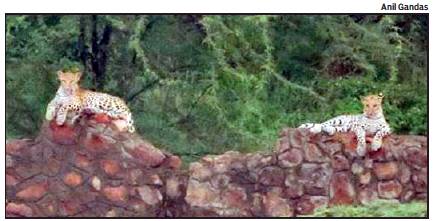
From: August 7, 2019: The Times of India
A female leopard and her two cubs were spotted in an Aravali area near Manesar.
Anil Gandas, a wildlife enthusiast, who spotted the big cats, said, “The eight-year-old female leopard was trying to prey on a blue bull, while the cubs were resting on a wall. I went to the Aravalis to release one of the snakes I had rescued. After photographing the animals, I left the area quietly as staying there for long could disturb them.”
Locals said they have dug two waterholes for leopards in the area. “Villagers often spot leopards here,” said Ram Avtar Yadav, an activist. District forest officer Subhash Yadav said, “The sightings of leopards have definitely increased in the Aravalis of south Haryana. This calls for a need to save the Aravalis.”
Even though this is not the first time that a leopard has been spotted in a forest area near the city, the recent sightings indicate that the Aravalis is home to the big cat, and its presence is increasing in the Aravalis. A study conducted by the Wildlife Institute of India (WII) in 2017 also indicated presence of wild animals, including leopards and hyenas, in this area of the Aravalis. As per the study, the highest leopard occupancy in the Aravalis is in Gurgaon and Faridabad in the state, and total area under leopard occupancy was estimated to be 200.9 sq km. The study stated that the most sensitive areas are Raisina, Manesar, Nuh, Mohamadpur Ahir, Bhondsi, Damdama, Mangarbani and Mandawar.
