Aravali range
(→Natural Conservation Zone) |
m (Pdewan moved page Aravalis: India to Aravali range without leaving a redirect) |
Revision as of 10:52, 21 December 2016
This is a collection of articles archived for the excellence of their content. Readers will be able to edit existing articles and post new articles directly |
Contents |
Places in need for conservation
Aravalis, Lake Damdama: Aravali’s Last Lake in Danger

Haryana to allow houses on hillock next to Damdama Any structure on the hill will block flow of rainwater, thereby endangering the future of the water body Dipak Kumar Dash | TNN
Damdama (Gurgaon): Another lake in the Aravalis may soon be consigned to oblivion. If Surajkund and Badhkal lakes succumbed to mining activities in the Aravalis, Damdama, the last surviving water body in the region, may also go dry thanks to the government’s short-sighted policy that will soon facilitate construction in the area.
The revenue department in Gurgaon has almost completed the consolidation (Chakbandi) of plots on a hillock — Roj Ka Gujjar — spread over 5,744 acres adjacent to the lake. This will allow owners to construct houses on their plots. And any structure on the hillock, say environmentalists, will obstruct smooth flow of rainwater, the only source of replenishment, to the lake, almost 40 km from the national capital.
‘‘Any activity in the region will mean that the flow of rainwater to the lake will stop or would be adversely affected. Moreover, people will end up extracting groundwater, which is equally damaging,’’ said R P Balwan, former conservator of forest of southern circle (Gurgaon).
Originally, the hill was commonly owned by residents of 12 villages in the region. ‘‘But almost 90% of the land on the hill has already been sold to outsiders, mostly from Delhi. This had been happening since 1980s. The original owners have sold their shares, though those were not identified. After the consolidation, plots will be demarcated and given to the new individual owners. Those who have bought land are rich and influential people,’’ said a revenue department official.
However, he added that when the department was about to notify consolidation, a scam was detected and the process was put on hold. ‘‘We found that the total land sold was more than the actual area of Roj Ka Gujjar. An additional 631 acres had been sold. The regional commissioner has ordered us to halt the process of handing over of the plots,’’ he added.
The list of discrepancies doesn’t end there. The Ministry of Environment and Forest (MoEF) had written to Haryana government in December 1992 mentioning that all the areas notified under Punjab Land Preservation Act (PLPA) are forests and such areas cannot be used for non-forestry activities without prior permission from the ministry. Though Roj Ka Gujjar is covered under PLPA, its land is now up for consolidation.
Balwan said that construction of any dwelling unit, road or path, electricity poles has also been prohibited. Moreover, the hillock was also covered under Aravali plantation, which has been declared as deemed forest by the Supreme Court. ‘‘The revenue department should not have allowed the sale and purchase of common land since it was not demarcated or fragmented,’’ he added.
But, people who have bought land adjoining the half-dry waterbed of Damdama have started constructing boundary walls. ‘‘In the last few years, more people have bought land around the lake. Things would get worse when more people will occupy the hilltop,’’ cautions Bane Singh, a resident of Damdama village.
Sources said that the revenue department wants to ensure that the drains and streams, which carry rainwater to the lake, are not blocked. ‘‘We have included this in the consolidation scheme so that the natural water supply to the lake is not disturbed. Though consolidation would be finalised soon, land owners would have to get approval for anything they do on their land,’’ said a senior revenue department official.
Conservation mechanisms
Steps taken, state-wise
Haryana, 2016: protection of "potential" wildlife areas
The Times of India, Feb 05 2016
Wildlife study to find focus spots
Jayashree Nandi
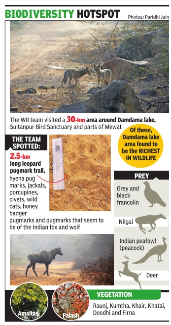
A study by the Wildlife Institute of India (WII) will soon point out “potential“ wildlife areas in the Aravalis in Haryana that require special conservation measures and protection from urbanisation. The Haryana forest department had commissioned WII to carry out a survey to identify vulnerable areas that needed government intervention.
The Aravali range ends in Haryana and is, therefore, an ecologically fragile region that is threatened by modernity . Unlike in Rajasthan, which has a number of protected areas, including the Sariska National Park, the wildlife-rich areas of Haryana had never been identified. “The forest department wants to have a document at hand to be able to resist any pressure to change land use,“ said Bilal Habib of the animal ecology and conservation biology department at WII.
The WII team comprising project biologists Anchal Bhasin and Paridhi Jain, along with local villagers, have finished scouting a 30-km area around Damdama lake, Sultanpur Bird Sanctuary and parts of Mewat in the past month or so.They found ample evidence of wildlife, particularly around Damdama lake, including a 2.5-km-long trail of leopard pugmarks. They also noticed hyena pugmarks and some unidentified pugmarks that could be of the Indian fox.
Despite the presence of tigers in the Rajasthan Aravalis, the WII team isn't quite hopeful of finding the big cats on the Haryana side because the habitat is quite degraded. “There is too much human presence and disturbance for tigers to be living here. Tigers also don't prefer undulating terrain as habitats,“ explained Bhasin.She said that if it could be confirmed that the Indian fox could indeed be found here, it would be an important discovery .Indicators of leopard presence are, of course, the most important discovery because it means there are many other smal ler animals living there on which the spotted cats prey .
Natural Conservation Zone
The Times of India, April 7, 2016

The Times of India

Bagish Jha
NCR May Lose Major Water Recharge Zones Due To Land-Use Change
Over 90% of foothills out of NCZ?
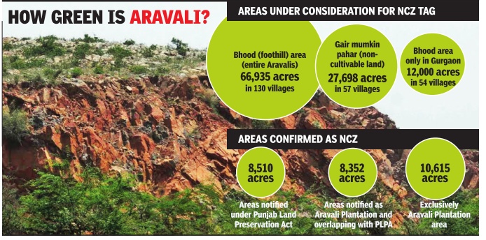
Large tracts of land in Aravali foothills are likely to remain out of the proposed natural conservation zone (NCZ), mainly due to change in land use of these areas in the past decades. Out of the 1,200 acres of bhood (a revenue term for foothills of Aravalis) in Gurgaon, only 80 acres are expected to be incorporated in NCZ, as land use of the rest of the land has been changed, purportedly to avoid classification as forest land that makes its use for any commercial project impossible.
An exercise for a fresh and scientific demarcation of NCZs has been on for months and a committee overseeing it is expected to submit its final proposal by April 13.
According to environmentalists, bhood areas are important water recharge zones and their conservation is important for recharging the groundwater of the entire NCR. They fear exclusion of bhood areas from NCZ will have a serious implication on the ecological balance of the region.
A government source said ownership of most of the land that may be excluded from the demarcation exercise, lies indirectly with realtors. “Developers are waiting for the NCZ notification to go ahead with their plan to build residential complexes in these area after changing land use from agricultural,“ the source said.
Additional chief secretary , department of town and country planning, P Raghvendra Rao said on Wednesday a final decision had not been taken yet and only discussions on definitions of certain revenue terms and how to assess areas under NCZ had taken place.“The district-level committee will finalise things and submit the proposal for demarcation of NCZ. There are differences of opinion on certain issues.We will look into them once the proposal was submitted by the district-level committee,“ said Rao.
He added, “We have an open mind and we are very concerned about environment and water recharge zones. So, if some issues were raised by anyone, we will consider them.“ He said NCZ areas had almost been finalised in Haryana's NCR districts except in some parts of Gurgaon and Mewat.
Forest officials have objected to exclusion of foothills from NCZ. “Land use was changes only on paper. Large tracts are still as they were decades back. These areas should be included in NCZ,“ said a senior forest official. A forest official clarified that areas like bhood, wasteland and paleochannels (streams that once existed but don't any more) are not notified as forest, so they can only suggest their inclusion.
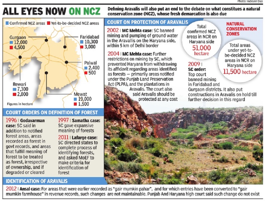
“Nearly 11,910 hectares of land in Gurgaon is confirmed under NCZ and a large tract of land is under `yet to be decided' NCZ,“ Gurgaon deputy commissioner T L Satyaprakash said. Large parts of the land in the `yet to be decided' category are owned by private individuals and some of it under litigation, he added.
According to Satyaprakash, several years back, nearly 1,200 acres of land in Gurgaon was under bhood. “Over a period, land use changed and today most of this land is irrigated agriculture land in government records. Now, only 80 acres of this land remains as bhood,“ said Satyaprakash, He added that it would be difficult to include 1,200 acre of bhood under NCZ.
Similarly , wasteland and palaeochannel are not record ed in revenue records. “So we are not able to identify them.So, incorporating them in NCZ would be difficult,“ he said.
Originally, only land notified as forest, Aravali Plantation and land protected under Sections 4 & 5 of Punjab and Haryana Land Protection Act, 1990, water bodies and some other areas were to be identified as Natural Conservation Zone. “Later, on the request of government departments and some people, more areas were incorporated,“ said Satyaprakash. “The land use was changed illegally . Excluding areas under foothills will lead to destruction of Aravali and it will defeat the entire purpose of demarcating NCZ,“ said environmentalist Col SS Oberai.
December 2016: Sanction by NCR Planning Board
The Times of India, Dec 21 2016
Dipak Dash
NCRPB Decision Paves Way For Conservation Of Range
NCR Planning Board (NCRPB) put its stamp on bringing all noncultivable hill land, rocky and sandy areas in the ecologically sensitive Aravalis across NCR within the ambit of the mountain range. This decision paves the way for protection and conservation of Aravalis, which has been on the radar of real estate developers. No non-forest activity is allowed in Aravalis without prior permission of environment and forest ministry , meaning there will be hardly any scope for real estate or other construction work in such areas.
The decision was taken at the board meeting chaired by urban development minister M Venkaiah Naidu and attended by Haryana chief minister Manohar Lal Khattar besides representatives from Delhi and Rajasthan government.
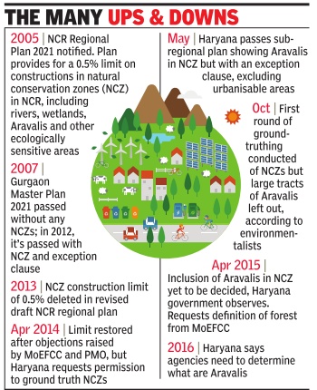
However, what stumped many in the meeting was a request by a top Haryana government official reiterating the demand to remove restrictions on construction in Natural Conservation Zone (NCZ), which covers entire Aravali, lakes and water recharge zones. The Regional Plan of NCR, which has the consent of Haryana government, clearly treats the entire Aravalis as NCZ where construction is not allowed beyond 0.5% of the area.
The senior Haryana offici al raising the issue of doing away with this cap on construction shows how state bureaucracy is sticking to its demand of more construction in the ecologically fragile zone despite change of government. The earlier Bhupinder Singh Hooda government had unsuccessfully pushed for a similar course of action. Sources said Haryana officials want that allowing any construction activities in NCZ should be subject to approval from the environment ministry rather than having any overall limit on construction in such areas.
“The Board also clarified the position regarding demarcation of Aravalli range and delineation of NCZ. It said that the notification issued by the Ministry of Environment and Forests in 1992 has clearly explained for districts of Gurgaon in Haryana and Alwar in Rajasthan for regulating certain processes and operations in specified areas of Aravali range and this notification would guide identification and delineation of Aravalis in the entire NCR,“ an official statement from urban development ministry said.
Minister of state for urban development Rao Inderjit Singh said the curbs on construction in Aravalis and water recharge zones is essential for “sustainable development“ of the NCR. “It becomes our responsibility to protect this area for future generation,“ he told
Nature Education and Cure Centre
The Times of India, Demcember 13, 2016
Dipak Dash
In a controversial move, the Haryana forest department has proposed to issue a “corrigendum“ to de-notify 85 acres of forest land in the Aravalis in Gurugram where a `Nature Education and Cure Centre' will be set up in publicprivate partnership mode.
The land, along with another 500 acres, was repossessed by Haryana government in 2001 from Bharat Yatra Kendra, which included the “farm house“ of former PM Chandrasekhar, after his demise. The possession was transferred following a Supreme Court order. While 500 acres went back to the forest department, 85 acres, with nearly 20 structures, was restored to the gram panchayat.
The gram panchayat gave the 85 acres to the forest de partment to manage it, under section 38 of Forest Conservation Act. The entire 585 acres was notified as forest in 2004.The forest department later gave the land to Haryana Forest Development Corporation.
“Issuing corrigendum is an afterthought or a bureaucratic ploy to mislead political bosses to de-notify any forest land. This will open the floodgates for misuse, as both government agencies and private players are eyeing Aravalis for commercial exploitation,“ said R P Balwan, former conservator of forests.
He added there were efforts to use protected forest in Shivalik hill in the state for raising medicinal plants.“Under FCA, you cannot denotify a forest area and these cannot be used for commercial purpose. How can HFDC, which is only caretaker on behalf of forest department, moot a proposal to roll out a PPP project, which is nothing more than providing an entry to private players in forest area?“ Balwan said.
Groundwater pollution
2016: CGWA partially concurs with reports
The Times of India, Apr 20 2016
'Aravali waste spill A spoils groundwater'
Bagish Jha The Central Ground Water Authority (CGWA), in the affidavit filed before the National Green Tribunal (NGT), has partially agreed to the allegation in a petition that the groundwater in Aravalis is being polluted by untreated waste lying near Bandhwari waste treatment plant on Gurgaon-Faridabad road.
In its three-page affidavit, filed on the direction of the NGT, CGWA has agreed to most of the allegation related to unscientific dumping of waste around Bandhwari waste plant by municipal corporations of Gurgaon and Faridabad. It also taken notice of the claims that leachate has contaminated ground water, thus affecting Gurgaon, Delhi and Faridabad water tables.
The CGWA affidavit has accepted that report published in TOI on September 8, 2015 that the pit where a lake of leachate has been created us ed to be a seasonal water body of the village, and that the contamination might have even made the water carcinogenic.
The affidavit also put the onus of providing an explanation to the claims made in the petition on MCG. “Municipal solid waste management falls under the purview of the local municipal bodies. The concerned local municipal bodies are believed to be exercising their constitutional powers and functions to enforce the municipal lawsrules. The municipal bodies have since been made parties in the matter, they will explain their stand,“ reads the affidavit.
