Bio-diversity in Jammu, Kashmir, Ladakh: Cultural and Historical Background
(→Climate) |
|||
| Line 663: | Line 663: | ||
1. Sub tropical Zone: The parts of Jammu, Kathua, Udhampur, Poonch and Rajouri Districts have sub-tropical climatic zones with mean hight above the sea level ranging from 300m to 1350 metres having hot summers and dry pronounced winters with heavy rainfall during monsoon months. | 1. Sub tropical Zone: The parts of Jammu, Kathua, Udhampur, Poonch and Rajouri Districts have sub-tropical climatic zones with mean hight above the sea level ranging from 300m to 1350 metres having hot summers and dry pronounced winters with heavy rainfall during monsoon months. | ||
| + | |||
2. Valley temperate Zone: This zone covers many parts of Kashmir valley and inner Himalayan areas with average height ranging from 1560 m. to 4200 m having wet and cold winters and relatively dry and moderately hot summers. | 2. Valley temperate Zone: This zone covers many parts of Kashmir valley and inner Himalayan areas with average height ranging from 1560 m. to 4200 m having wet and cold winters and relatively dry and moderately hot summers. | ||
| + | |||
3. Dry temperate: The parts of Rajouri and Doda districts having altitudinal variation from 1350 m to 3000 m with relatively wetter and colder weathers and monsoon rainfall in Aug-Sep. months. | 3. Dry temperate: The parts of Rajouri and Doda districts having altitudinal variation from 1350 m to 3000 m with relatively wetter and colder weathers and monsoon rainfall in Aug-Sep. months. | ||
| + | |||
4. Cold Arid zone: This zone covers the districts of Ladakh and Kargil in the East and Gilgit and adjacent areas in the North-west. The altitude ranges from 7200 m to 8400 m. Winters are exceptionally cold and dry and summers are moderately hot and dry. | 4. Cold Arid zone: This zone covers the districts of Ladakh and Kargil in the East and Gilgit and adjacent areas in the North-west. The altitude ranges from 7200 m to 8400 m. Winters are exceptionally cold and dry and summers are moderately hot and dry. | ||
| + | |||
5. Intermediate zone: This zone covers mid and high altitude areas of Doda, Poonch, Rajouri and Udhampur Districts where rainfall pattern resembles closely to that of the valley temperate zone but the summer rainfall resembles the precipitation pattern of the sub-tropical zone. | 5. Intermediate zone: This zone covers mid and high altitude areas of Doda, Poonch, Rajouri and Udhampur Districts where rainfall pattern resembles closely to that of the valley temperate zone but the summer rainfall resembles the precipitation pattern of the sub-tropical zone. | ||
Revision as of 19:42, 3 February 2014
This article has been sourced from an authoritative, official readers who wish to update or add further details can do so on a ‘Part II’ of this article. |
Contents |
The source of this article
Bio-diversity in Jammu, Kashmir, Ladakh
By the Department of Forests, Government of Jammu and Kashmir
The three regions of Jammu, Kashmir and Ladakh were brought together under a single state in 1846. Kashmir has a very ancient history reflected in historical accounts and discussed in famous ‘Rajtarangni’. As part of Ashoka’s Empire and Kushan Empire, it was flourishing center of Buddhist culture for many centuries. The ruins of impressive temples at Martand, Pattan and Avantipora bear testimony to the great Hindu culture under the Hindu dynasties that flourished till 14th century. The most famous of the Hindu kings was Lalitaditya.
Islam came to Kashmir much later when a series of preachers from Iran and Central Asia entered here. Sultan Zain-ul-Abidin who ruled for the 1st half of the 15th century was tolerant towards Hindu religion, he is credited with the introduction of many arts and crafts including shawl and carpet weaving, wood carving and paper mache work. Akbar the great conquered Kashmir in 1585 and it became a favorite resort for the Emperor Jahanghir. It was during the empire of Jahanghir that foundation of World famous Mughal Gardens was laid and the grandeur persists to the present times.
Ladakh was an independent country before 10th century A.D. the ruling Tibetan dynasty remained preacher of Buddhism and Ladakhi culture developed on its own as an offshoot of that of Tibet. The Central Asian Merchants and other missionaries added Islamic culture in the area. By the 18th century the Drass and Purig areas of western Ladakh became Muslim dominated though central Ladakh, Nobra and Eastern Areas retained the older faith of Buddhism. Ladakh’s prosperity was based largely on trade which was carried out through the ancient silk route. It was the only channel for the supply of pashm (pashmina) produced on its own pastures.
The Jammu region was initially a cluster of small Himalayan kingdoms until these got consolidated under a single political unit by the Dogra Chief, Maharaja Gulab Singh and his brothers. Jammu town acquired importance for the trade in Kashmir Shawls and other commodities during 18th century which led to decay of Lahore – Delhi route. The Shawl merchants preferred to cross the Banihal-pass to enter into Jammu markets and reached as far as Moradabad. In 1834 Gulab Singh sent an army to invade Ladakh and he concurred Baltistan adjoining Ladakh down the Indus river. Four years later by the treaties of Lahore and Amritsar the British recognized Gulab Singh as ruler of Kashmir as well as of Jammu and Ladakh in consideration of his paying half of the indemnity of 1.5 crore Rupees. Thus the state of J&K as we know presently came into existence.
A century later and immediately after the independence and partition raiders from Pakistan invaded Kashmir in an attempt to take it by force but the then Maharaja Hari Singh of the state supported by the National Conference and the Government of India failed their evil designs and signed the Instrument of Accession with India. In 1957 the Kashmir Assembly confirmed the Instrument of Accession by declaring the State as an integral part of India. Pakistan has however never accepted this position and fought three major wars in 1947, 1965 & 1971 and has been badly defeated. Now Pakistan is engaged in proxy war by sending trained and armed militants who are killing innocent people and destroying property and assets of the state. Because of the prevalent disturbed conditions many of the developmental projects have suffered a set-back and economy of the state has also been badly affected.
Geographical Profile
Area & Location
The state of Jammu & Kashmir is located in the North-western part of Indian Republic and lies between 32°-17’ and 37°-5’ North latitude and 73°-26’ and 80°-30’ East longitude and holds an almost central position in the continent of Asia. It occupies about 6.74 percent of the total area of the country and has a total geographical area of 222236 square kilometers. Out of this total geographical area of the state 78114 sq. kilometers is under illegal occupation of Pakistan and 42735 square kilometers under China.
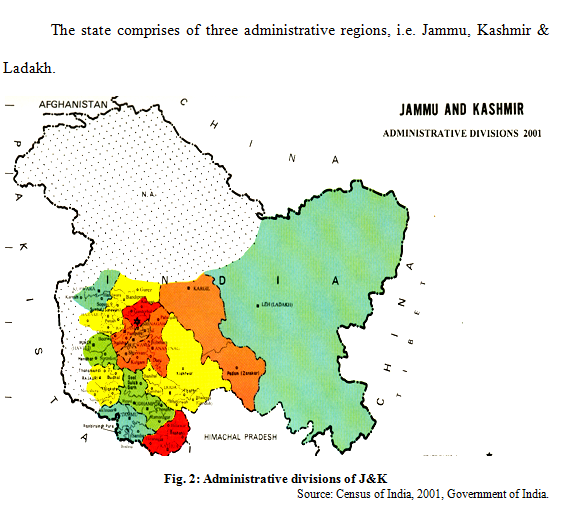
The state comprises of three administrative regions, i.e. Jammu, Kashmir & Ladakh.
Physiography, Relief and Drainage
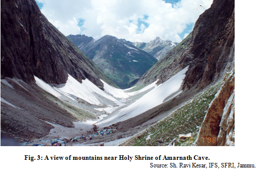
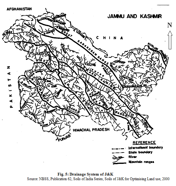
The J&K region consists of four great mountain ranges of Himalayas, the Karakoram, the Ladakh, the Zanskar and Pirpanjal. Between these ranges are the longitudinal valleys of Gilgit, Shyok, Indus and Jehlum. South of Pirpanjal is the Shivalik range comparatively much lower in elevation and known as Jammu hills. Further south there is a narrow strip of foot hill plains (25 kms vide) merging into Punjab plains.
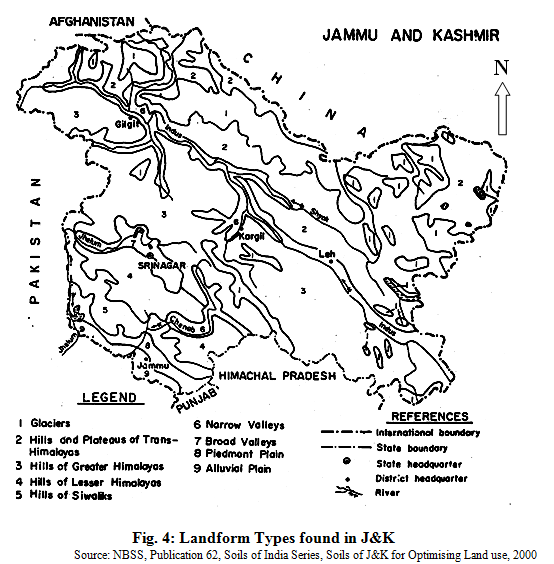
The state is divided into 5 physiographic regions i.e. Trans Himalayas, Greater Himalayas, Lesser Himalayas, Shivaliks and Plains which have been further divided into 9 land forms and they are enumerated below:
1. Glaciers
2. Hills and Plateaus of Trans-Himalayas
3. Hills of Greater Himalayas
4. Hills of Lesser Himalayas
5. Hills of Siwaliks
6. Narrow Valleys
7. Broad valleys
8. Piedmont Plains
9. Alluvial plain.
Ladakh region is drained by river Indus and its tributaries like Shyok, Shigar, Gilgit and Astor. Jhelum river drains out valley of Kashmir while the Chenab river drains the eastern section of southern slopes of the Pir Panjal, Jammu hills and the foothill plains. The parts of Jammu region adjoining Punjab and Himachal Pradesh are drained by river Ravi and its tributaries such as Tawi, Munawer Tawi etc. Drainage system of the state is given below:
Table 1: Geographical Area & Forest Area of J&K |
||||
|
S.No. |
Division |
Geographical Area in Sq. Kms |
Forest Area in Sq. Kms. |
Forest Area Percentage |
|
1. |
<st1:City w:st="on">Jammu</st1:City> |
26293 |
12050 |
45.83 |
|
2. |
<st1:place w:st="on">Kashmir |
15948 |
8115 |
50.88 |
|
3. |
Ladakh |
59146 |
17 |
0.03 |
|
4. |
Area under illegal occupation of <st1:place w:st="on">Pakistan |
78114 |
- |
- |
|
5. |
Area under illegal occupation of <st1:place w:st="on">China |
42735 |
- |
- |
|
Total Area |
222236 |
20182 |
9.08 |
|
Source: Forest Statistics Digest
The state of Jammu & Kashmir is mountainous and shares international boundaries with Pakistan in the west, Chinese autonomous regions of Xinjiang in the North and Tibet to the North East. It is connected to the rest of the country through a 30 Km long boundary with Punjab and 300 km long boundary with Himachal Pradesh. The state has three main territories of Jammu, Kashmir and Ladakh that differ in terms of climate, topography, flora, fauna, ethnic groups, religious and cultural traditions and local health practices.
Table 2: The characteristic features of 3 regions of J&K
|
Physiographic region |
<st1:City w:st="on">Jammu</st1:City> |
<st1:place w:st="on">Kashmir |
Ladakh |
|
Altitude |
300-4000 m |
2000-5000 m |
4000-6000 m |
|
Annual rainfall |
1148 mm |
664 mm |
115 mm (Leh) 757 mm (Drass) 306 mm (Kargil) |
|
Vegetation |
Sub tropical dry deciduous forests and coniferous forests |
Moist temperate and alpine vegetation |
Cold desert scrub vegetation |
|
Water availability |
Moderate to Scanty |
Moderate |
Scanty |
|
Local Ethnic groups |
Dogras, Chibhalis, Gujjars, Bakker-wals, Gaddis, |
Kashmiris, Hanjis, Gujjars, Bakkerwals. |
<st1:City w:st="on">Mons</st1:City>, Drokpas, Changpas, Amchis, Balti, |
|
Language |
Dogri, Gojri, Pahari, Kashmiri, |
Kashmiri, Gojri, Pahari, |
Ladakhi |
|
Population |
3537957 |
4210202 |
170541 |
|
Districts |
6 |
6 |
2 |
Source: Forest Statistics Digest.
Geology
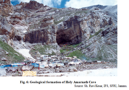
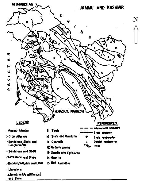
The region represents mixed geological formations ranging from Archacans to recent. Crystalline rocks like granite and gneisses of Archacan age occur mainly in the Zanskar range, Gilgit, Baltistan and Ladakh. Slates, phyllites, schists, quartzites, crystalline limestone and dolomites are found to occupy the tracts of west Ladakh, north Hazara, Gilgit and Zanskar range. Limestone and shales are found extensively in the Karakoram range. Dogra slates and quartzites occur in the south-west flanks of Pir panjal.
Shiwalik hills dominantly occupy Jammu region and are composed of sandstones, shales and conglomerates. Foot-hill plains and valleys are formed from alluvium deposits. The geological map of the state is given below:
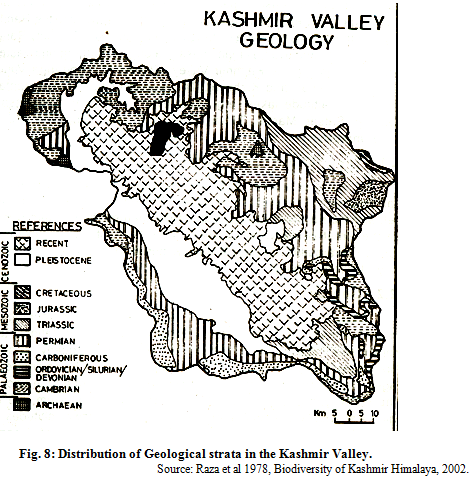
The distribution of Geological strata in the Kashmir Valley is reproduced as under:
Climate
The climate of Jammu and Kashmir varies from sub-tropical monsoon type of Jammu, cold temperate of mountainous regions of Kashmir & Jammu to cold desert conditions of Ladakh. The climate of Jammu is characterized by Hot summers and cold winters with heavy rainfall during August & September months, The climate of Kashmir is of cold temperate type with heavy precipitation during winter months and spring season. The climate of Ladakh is of extreme cold type with almost negligible annual precipitation. After a gap of three years, Ladakh region has experienced snowfall in the month of March this year. There are considerable differences in weather conditions from season to season with extreme hot summers and severe winters in Jammu province; mild summers and chilled winters in Kashmir and mild summers to extremely freezing winters in Ladakh with freezing temperatures falling down to –45° C in Dras and Changthang areas. The annual rainfall of Jammu province varies from 800 mm to 4000 mm in different regions, the annual rain fall of Kashmir varies from 500 mm to 2500 mm. Five broad macro-climatic zones stands differentiated as sub-tropical, valley temperate intermediate, Dry temperate and cold arid types.
1. Sub tropical Zone: The parts of Jammu, Kathua, Udhampur, Poonch and Rajouri Districts have sub-tropical climatic zones with mean hight above the sea level ranging from 300m to 1350 metres having hot summers and dry pronounced winters with heavy rainfall during monsoon months.
2. Valley temperate Zone: This zone covers many parts of Kashmir valley and inner Himalayan areas with average height ranging from 1560 m. to 4200 m having wet and cold winters and relatively dry and moderately hot summers.
3. Dry temperate: The parts of Rajouri and Doda districts having altitudinal variation from 1350 m to 3000 m with relatively wetter and colder weathers and monsoon rainfall in Aug-Sep. months.
4. Cold Arid zone: This zone covers the districts of Ladakh and Kargil in the East and Gilgit and adjacent areas in the North-west. The altitude ranges from 7200 m to 8400 m. Winters are exceptionally cold and dry and summers are moderately hot and dry.
5. Intermediate zone: This zone covers mid and high altitude areas of Doda, Poonch, Rajouri and Udhampur Districts where rainfall pattern resembles closely to that of the valley temperate zone but the summer rainfall resembles the precipitation pattern of the sub-tropical zone.